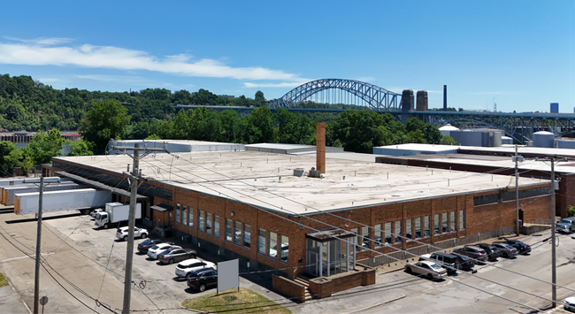
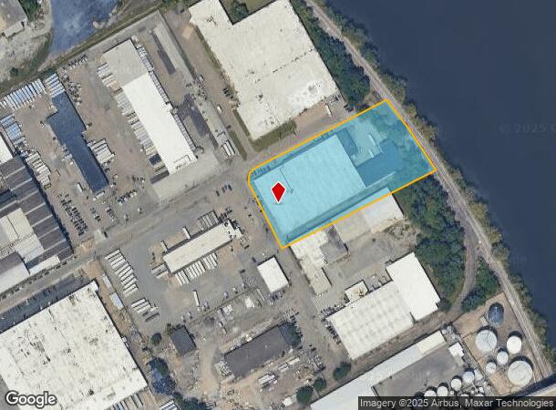
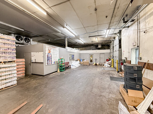
Property Record
1 Sexton Rd, Mc Kees Rocks, PA 15136
This Property Is For Sale
NEARBY LISTINGS FOR SALE OR LEASE
Property Detail
1 Sexton Rd
Pittsburgh, PA
3 A D SEXTON RD 1 STY BRK & C B W HSE & GAR 1 STY METAL BLDG
0074-H-00072-0000-00
Allegheny
Warehouse
Pennsylvania
AE
72
42003C0331H
3 AC
2024
West Pittsburgh
2025
Pittsburgh
462100
DEMOGRAPHICS near 1 Sexton Rd
1 mile
3 mile
5 mile
2024 Total Population
11,256
95,072
219,249
2029 Population
11,072
93,504
215,930
Pop Growth 2024-2029
(1.63%)
(1.65%)
(1.51%)
Average Age
39
41
41
2024 Total Households
5,181
43,353
102,593
HH Growth 2024-2029
(1.80%)
(1.77%)
(1.47%)
Median Household Inc
$43,804
$55,558
$65,872
Avg Household Size
2.10
2.10
2.00
2024 Avg HH Vehicles
1.00
1.00
1.00
Median Home Value
$127,489
$149,375
$181,737
Median Year Built
1947
1948
1954
Nearby Places
Map Layers
Map Styles
 Street
 Aerial
Transit
 Traffic
 Biking
Places
Listings with unknown addresses are not visible on the map
- Restaurants
- Banks
- Shops
- Fitness
- Groceries
PUBLIC TRANSPORTATION
COMMUTER RAIL
Pittsburgh Amtrak Station (Capitol Limited - Amtrak, Pennsylvanian - Amtrak)
Drive
Walk
Distance
Pittsburgh Amtrak Station (Capitol Limited - Amtrak, Pennsylvanian - Amtrak)
12 min
5.7 mi
AIRPORT
Pittsburgh International
Drive
Walk
Distance
Pittsburgh International
28 min
13.6 mi
Freight Ports
Port of Toledo
Drive
Walk
Distance
Port of Toledo
266 min
228.6 mi
Nearby Properties
Address
Land Use
TOTAL SIZE
Lot Size
Zoning
Address
Land Use
TOTAL SIZE
Lot Size
Zoning
13.75 AC
Address
Land Use
TOTAL SIZE
Lot Size
Zoning
26.68 AC
Address
Land Use
TOTAL SIZE
Lot Size
Zoning
Address
Land Use
TOTAL SIZE
Lot Size
Zoning
21.20 AC
Address
Land Use
TOTAL SIZE
Lot Size
Zoning
6.55 AC
Address
Land Use
TOTAL SIZE
Lot Size
Zoning
1.66 AC
Address
Land Use
TOTAL SIZE
Lot Size
Zoning
6.40 AC
Address
Land Use
TOTAL SIZE
Lot Size
Zoning
1.22 AC
Address
Land Use
TOTAL SIZE
Lot Size
Zoning
1,556 SF
36.30 AC
Address
Land Use
TOTAL SIZE
Lot Size
Zoning
25.70 AC
Address
Land Use
TOTAL SIZE
Lot Size
Zoning
Address
Land Use
TOTAL SIZE
Lot Size
Zoning
72.69 AC
Address
Land Use
TOTAL SIZE
Lot Size
Zoning
25.09 AC
Address
Land Use
TOTAL SIZE
Lot Size
Zoning
Address
Land Use
TOTAL SIZE
Lot Size
Zoning
24.04 AC
Address
Land Use
TOTAL SIZE
Lot Size
Zoning
39.74 AC
Address
Land Use
TOTAL SIZE
Lot Size
Zoning
Address
Land Use
TOTAL SIZE
Lot Size
Zoning
3.83 AC
Address
Land Use
TOTAL SIZE
Lot Size
Zoning
13.86 AC
Address
Land Use
TOTAL SIZE
Lot Size
Zoning
Address
Land Use
TOTAL SIZE
Lot Size
Zoning
Address
Land Use
TOTAL SIZE
Lot Size
Zoning
15.86 AC
Address
Land Use
TOTAL SIZE
Lot Size
Zoning
2.51 AC
Address
Land Use
TOTAL SIZE
Lot Size
Zoning
9.18 AC
Address
Land Use
TOTAL SIZE
Lot Size
Zoning
21.49 AC
Address
Land Use
TOTAL SIZE
Lot Size
Zoning
Address
Land Use
TOTAL SIZE
Lot Size
Zoning
Address
Land Use
TOTAL SIZE
Lot Size
Zoning
30.79 AC
Address
Land Use
TOTAL SIZE
Lot Size
Zoning
5.74 AC
Address
Land Use
TOTAL SIZE
Lot Size
Zoning
18.19 AC
The World's #1 Commercial Real Estate Marketplace
Connect with us
© 2026 CoStar Group
The information above has been obtained from sources believed reliable. While we do not doubt its accuracy we have not verified it and make no guarantee, warranty or representation about it. It is your responsibility to independently confirm its accuracy and completeness. Any projections, opinions, assumptions, or estimates used are for example only and do not represent the current or future performance of the property. The value of this transaction to you depends on tax and other factors which should be evaluated by your tax, financial, and legal advisors. You and your advisors should conduct a careful, independent investigation of the property to determine to your satisfaction the suitability of the property for your needs.