Property Record
1 Sherwood Ter, Lake Bluff, IL 60044
NEARBY LISTINGS FOR SALE OR LEASE
Property Detail
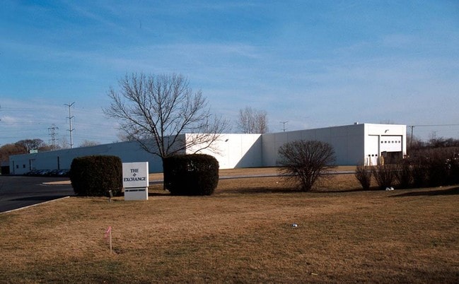
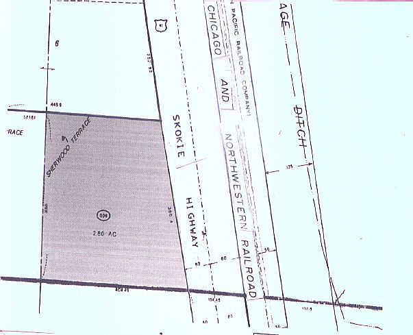
1 Sherwood Ter
12-20-300-006
Com At Sw Cor
Commercialbuilding
S 350 FT E 260 FT PT SE 1/4 SECTION 19 TOWNSHIP 44 RANGE 12
X
Lake
17097C0188K
Illinois
2023
2.80 AC
2024
South Lake County
863202
Chicago
65,954 SF
Chicago-Naperville-Elgin, IL-IN-WI
DEMOGRAPHICS near 1 Sherwood Ter
1 Mile
3 Mile
5 Mile
2024 Total Population
2,753
29,274
88,201
2029 Population
2,763
29,573
87,994
Pop Growth 2024-2029
+ 0.36%
+ 1.02%
(0.23%)
Average Age
44
41
40
2024 Total Households
1,075
10,662
29,801
HH Growth 2024-2029
+ 0.37%
+ 0.92%
(0.20%)
Median Household Inc
$155,993
$119,997
$115,101
Avg Household Size
2.50
2.50
2.60
2024 Avg HH Vehicles
2.00
2.00
2.00
Median Home Value
$666,916
$698,049
$576,759
Median Year Built
1976
1978
1976
Nearby Places
Map Layers
Map Styles
 Street
 Aerial
- Restaurants
- Banks
- Shops
- Fitness
- Groceries
PUBLIC TRANSPORTATION
COMMUTER RAIL
Lake Forest Station (Up-North) (Union Pacific North Line - Northeast Illinois Regional Commuter Railroad (Metra))
DRIVE
WALK
Distance
Lake Forest Station (Up-North) (Union Pacific North Line - Northeast Illinois Regional Commuter Railroad (Metra))
5 min
2.9 mi
Lake Bluff Station (Union Pacific North Line - Northeast Illinois Regional Commuter Railroad (Metra))
DRIVE
WALK
Distance
Lake Bluff Station (Union Pacific North Line - Northeast Illinois Regional Commuter Railroad (Metra))
8 min
3.2 mi
AIRPORT
Chicago O'Hare International
DRIVE
WALK
Distance
Chicago O'Hare International
34 min
25.0 mi
Freight Ports
Port Milwaukee
DRIVE
WALK
Distance
Port Milwaukee
66 min
54.9 mi
Nearby Properties
Address
Land Use
TOTAL SIZE
Lot Size
Zoning
Address
Land Use
TOTAL SIZE
Lot Size
Zoning
182.08 AC
Address
Land Use
TOTAL SIZE
Lot Size
Zoning
74.05 AC
Address
Land Use
TOTAL SIZE
Lot Size
Zoning
19.93 AC
Address
Land Use
TOTAL SIZE
Lot Size
Zoning
296.29 AC
Address
Land Use
TOTAL SIZE
Lot Size
Zoning
51,750 SF
48.98 AC
Address
Land Use
TOTAL SIZE
Lot Size
Zoning
13.85 AC
Address
Land Use
TOTAL SIZE
Lot Size
Zoning
17.35 AC
Address
Land Use
TOTAL SIZE
Lot Size
Zoning
Address
Land Use
TOTAL SIZE
Lot Size
Zoning
253,218 SF
2.88 AC
Address
Land Use
TOTAL SIZE
Lot Size
Zoning
Address
Land Use
TOTAL SIZE
Lot Size
Zoning
12.45 AC
Address
Land Use
TOTAL SIZE
Lot Size
Zoning
7.98 AC
Address
Land Use
TOTAL SIZE
Lot Size
Zoning
70,404 SF
0.65 AC
Address
Land Use
TOTAL SIZE
Lot Size
Zoning
25.66 AC
Address
Land Use
TOTAL SIZE
Lot Size
Zoning
14.03 AC
Address
Land Use
TOTAL SIZE
Lot Size
Zoning
10.68 AC
Address
Land Use
TOTAL SIZE
Lot Size
Zoning
15.47 AC
Address
Land Use
TOTAL SIZE
Lot Size
Zoning
16.06 AC
Address
Land Use
TOTAL SIZE
Lot Size
Zoning
7.99 AC
Address
Land Use
TOTAL SIZE
Lot Size
Zoning
15.23 AC
Address
Land Use
TOTAL SIZE
Lot Size
Zoning
15.18 AC
Address
Land Use
TOTAL SIZE
Lot Size
Zoning
3.57 AC
Address
Land Use
TOTAL SIZE
Lot Size
Zoning
8.81 AC
Address
Land Use
TOTAL SIZE
Lot Size
Zoning
Address
Land Use
TOTAL SIZE
Lot Size
Zoning
225,626 SF
4.11 AC
Address
Land Use
TOTAL SIZE
Lot Size
Zoning
68,100 SF
1.28 AC
Address
Land Use
TOTAL SIZE
Lot Size
Zoning
Address
Land Use
TOTAL SIZE
Lot Size
Zoning
32,017 SF
1.83 AC
Address
Land Use
TOTAL SIZE
Lot Size
Zoning
394,910 SF
20.13 AC
Address
Land Use
TOTAL SIZE
Lot Size
Zoning
9.04 AC
The World's #1 Commercial Real Estate Marketplace
Connect with us
© 2025 CoStar Group
The information above has been obtained from sources believed reliable. While we do not doubt its accuracy we have not verified it and make no guarantee, warranty or representation about it. It is your responsibility to independently confirm its accuracy and completeness. Any projections, opinions, assumptions, or estimates used are for example only and do not represent the current or future performance of the property. The value of this transaction to you depends on tax and other factors which should be evaluated by your tax, financial, and legal advisors. You and your advisors should conduct a careful, independent investigation of the property to determine to your satisfaction the suitability of the property for your needs.