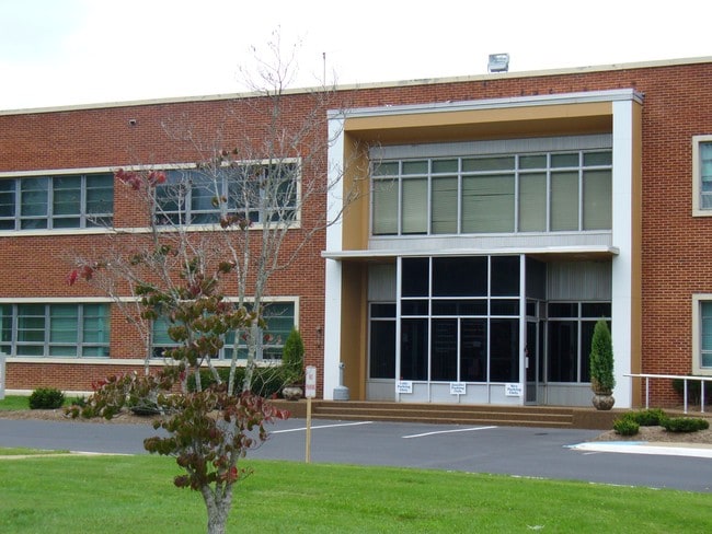
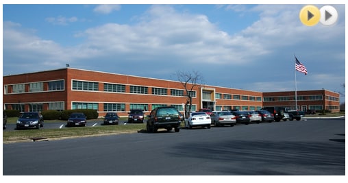
Property Record
1 Solution Way, Waynesboro, VA 22980

Property Detail
1 Solution Way
17-1-1
55.863 AC SMALL ACREAGE
Commercialnec
Waynesboro City
H-I
Virginia
AE The base floodplain where base flood elevations are provided. AE Zones are now used on new format FIRMs instead of A1-A30 Zones.
55.86 AC
2025
Staunton & Harrisonburg
2025
Other Market Areas
003200
Staunton-Stuarts Draft, VA
301,313 SF
NEARBY LISTINGS FOR SALE OR LEASE
DEMOGRAPHICS near 1 Solution Way
1 mile
3 mile
5 mile
2025 Total Population
2,378
21,807
33,665
2030 Population
2,474
22,715
34,919
Pop Growth 2025-2030
+ 4.04%
+ 4.16%
+ 3.72%
Average Age
41
42
43
2025 Total Households
994
9,309
14,277
HH Growth 2025-2030
+ 4.12%
+ 4.21%
+ 3.81%
Median Household Inc
$59,701
$58,354
$62,093
Avg Household Size
2.30
2.30
2.30
2025 Avg HH Vehicles
2.00
2.00
2.00
Median Home Value
$238,431
$254,947
$274,697
Median Year Built
1975
1975
1979
Nearby Places
Map Layers
Map Styles
 Street
 Aerial
Transit
 Traffic
 Biking
Places
Listings with unknown addresses are not visible on the map
- Restaurants
- Banks
- Shops
- Fitness
- Groceries
PUBLIC TRANSPORTATION
AIRPORT
Charlottesville-Albemarle
Drive
Walk
Distance
Charlottesville-Albemarle
54 min
36.0 mi
Nearby Properties
Address
Land Use
TOTAL SIZE
Lot Size
Zoning
Address
Land Use
TOTAL SIZE
Lot Size
Zoning
150,944 SF
22.24 AC
RG-5
Address
Land Use
TOTAL SIZE
Lot Size
Zoning
165,670 SF
5.31 AC
R-O
Address
Land Use
TOTAL SIZE
Lot Size
Zoning
94,535 SF
40.68 AC
GENERAL AG
Address
Land Use
TOTAL SIZE
Lot Size
Zoning
48,888 SF
9.01 AC
RG-5
Address
Land Use
TOTAL SIZE
Lot Size
Zoning
121,275 SF
18.39 AC
RG-5
Address
Land Use
TOTAL SIZE
Lot Size
Zoning
947 SF
13.62 AC
RG-5
Address
Land Use
TOTAL SIZE
Lot Size
Zoning
301,338 SF
21.52 AC
H-I
Address
Land Use
TOTAL SIZE
Lot Size
Zoning
75,609 SF
12.01 AC
RS-7
Address
Land Use
TOTAL SIZE
Lot Size
Zoning
5,624 SF
74.80 AC
H-I
Address
Land Use
TOTAL SIZE
Lot Size
Zoning
460 SF
144.09 AC
H-I
Address
Land Use
TOTAL SIZE
Lot Size
Zoning
7,512 SF
6.39 AC
R-MF
Address
Land Use
TOTAL SIZE
Lot Size
Zoning
1,844 SF
8.39 AC
R-MF
Address
Land Use
TOTAL SIZE
Lot Size
Zoning
2,460 SF
31.78 AC
PUD
Address
Land Use
TOTAL SIZE
Lot Size
Zoning
840 SF
1.70 AC
C-B
Address
Land Use
TOTAL SIZE
Lot Size
Zoning
41,574 SF
5.29 AC
H-B
Address
Land Use
TOTAL SIZE
Lot Size
Zoning
2,393 SF
6.81 AC
R-MF
Address
Land Use
TOTAL SIZE
Lot Size
Zoning
7,128 SF
3.75 AC
R-MF
Address
Land Use
TOTAL SIZE
Lot Size
Zoning
62,626 SF
1.15 AC
R-MF
Address
Land Use
TOTAL SIZE
Lot Size
Zoning
54,021 SF
9.74 AC
RS-7
Address
Land Use
TOTAL SIZE
Lot Size
Zoning
36,698 SF
0.90 AC
R-MF
Address
Land Use
TOTAL SIZE
Lot Size
Zoning
1,000 SF
4.17 AC
H-B
Address
Land Use
TOTAL SIZE
Lot Size
Zoning
42,122 SF
8 AC
RG-5
Address
Land Use
TOTAL SIZE
Lot Size
Zoning
106,752 SF
7.76 AC
H-I
Address
Land Use
TOTAL SIZE
Lot Size
Zoning
18,730 SF
2.43 AC
L-I
Address
Land Use
TOTAL SIZE
Lot Size
Zoning
16,324 SF
15.91 AC
H-B
Address
Land Use
TOTAL SIZE
Lot Size
Zoning
4,096 SF
2.24 AC
RG-5
Address
Land Use
TOTAL SIZE
Lot Size
Zoning
14,263 SF
0.48 AC
C-B
Address
Land Use
TOTAL SIZE
Lot Size
Zoning
93,866 SF
13.15 AC
H-B
Address
Land Use
TOTAL SIZE
Lot Size
Zoning
29,631 SF
7 AC
H-B
The World's #1 Commercial Real Estate Marketplace
Connect with us
© 2026 CoStar Group
The information above has been obtained from sources believed reliable. While we do not doubt its accuracy we have not verified it and make no guarantee, warranty or representation about it. It is your responsibility to independently confirm its accuracy and completeness. Any projections, opinions, assumptions, or estimates used are for example only and do not represent the current or future performance of the property. The value of this transaction to you depends on tax and other factors which should be evaluated by your tax, financial, and legal advisors. You and your advisors should conduct a careful, independent investigation of the property to determine to your satisfaction the suitability of the property for your needs.