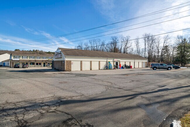
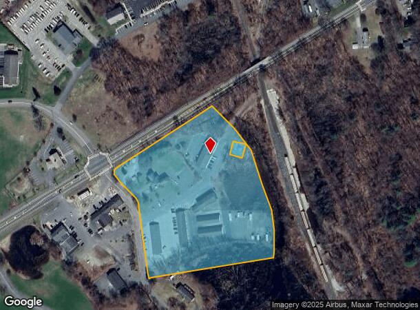
Property Record
1 Stadler St, Belchertown, MA 01007
NEARBY LISTINGS FOR SALE OR LEASE
-
-
View all Belchertown listings for sale on LoopNet.com
Property Detail
1 Stadler St
Springfield, MA
Hampshire
BELC-000243-000000-000152
Massachusetts
Commercialofficeresidentialmixeduse
152
2025
7.59 AC
2025
Hampshire County
820206
Hartford
DEMOGRAPHICS near 1 Stadler St
1 Mile
3 Mile
5 Mile
2024 Total Population
1,744
9,973
15,886
2029 Population
1,365
7,878
12,704
Pop Growth 2024-2029
(21.73%)
(21.01%)
(20.03%)
Average Age
43
43
43
2024 Total Households
758
4,055
6,262
HH Growth 2024-2029
(22.30%)
(21.97%)
(21.16%)
Median Household Inc
$77,893
$102,405
$103,995
Avg Household Size
2.30
2.40
2.50
2024 Avg HH Vehicles
2.00
2.00
2.00
Median Home Value
$285,713
$335,961
$336,479
Median Year Built
1979
1984
1983
Nearby Places
Map Layers
Map Styles
 Street
 Aerial
- Restaurants
- Banks
- Shops
- Fitness
- Groceries
PUBLIC TRANSPORTATION
AIRPORT
Bradley International
DRIVE
WALK
Distance
Bradley International
65 min
32.1 mi
Worcester Regional
DRIVE
WALK
Distance
Worcester Regional
70 min
37.1 mi
Freight Ports
Port of Davisville, RI
DRIVE
WALK
Distance
Port of Davisville, RI
130 min
98.1 mi
Nearby Properties
Address
Land Use
TOTAL SIZE
Lot Size
Zoning
Address
Land Use
TOTAL SIZE
Lot Size
Zoning
178,173 SF
46.03 AC
Address
Land Use
TOTAL SIZE
Lot Size
Zoning
87,896 SF
12.65 AC
Address
Land Use
TOTAL SIZE
Lot Size
Zoning
2,295.68 AC
AGA
Address
Land Use
TOTAL SIZE
Lot Size
Zoning
72,521 SF
14.98 AC
Address
Land Use
TOTAL SIZE
Lot Size
Zoning
347.63 AC
AGA
Address
Land Use
TOTAL SIZE
Lot Size
Zoning
197 AC
AGA
Address
Land Use
TOTAL SIZE
Lot Size
Zoning
30,000 SF
13.88 AC
Address
Land Use
TOTAL SIZE
Lot Size
Zoning
57,801 SF
8.73 AC
GB2
Address
Land Use
TOTAL SIZE
Lot Size
Zoning
60,270 SF
17.83 AC
Address
Land Use
TOTAL SIZE
Lot Size
Zoning
5,520 SF
12.33 AC
Address
Land Use
TOTAL SIZE
Lot Size
Zoning
6.96 AC
Address
Land Use
TOTAL SIZE
Lot Size
Zoning
38,676 SF
10.40 AC
Address
Land Use
TOTAL SIZE
Lot Size
Zoning
54,099 SF
3.18 AC
BNC
Address
Land Use
TOTAL SIZE
Lot Size
Zoning
6.36 AC
OR2
Address
Land Use
TOTAL SIZE
Lot Size
Zoning
20.74 AC
Address
Land Use
TOTAL SIZE
Lot Size
Zoning
7.20 AC
Address
Land Use
TOTAL SIZE
Lot Size
Zoning
1.24 AC
Address
Land Use
TOTAL SIZE
Lot Size
Zoning
32,251 SF
2.40 AC
Address
Land Use
TOTAL SIZE
Lot Size
Zoning
5.16 AC
Address
Land Use
TOTAL SIZE
Lot Size
Zoning
12.12 AC
Address
Land Use
TOTAL SIZE
Lot Size
Zoning
19,520 SF
4.03 AC
Address
Land Use
TOTAL SIZE
Lot Size
Zoning
10.50 AC
Address
Land Use
TOTAL SIZE
Lot Size
Zoning
20.39 AC
I
Address
Land Use
TOTAL SIZE
Lot Size
Zoning
670 AC
AGA
Address
Land Use
TOTAL SIZE
Lot Size
Zoning
45.55 AC
I
Address
Land Use
TOTAL SIZE
Lot Size
Zoning
3,204 SF
158.35 AC
Address
Land Use
TOTAL SIZE
Lot Size
Zoning
4,554 SF
0.90 AC
Address
Land Use
TOTAL SIZE
Lot Size
Zoning
10,757 SF
2.19 AC
Address
Land Use
TOTAL SIZE
Lot Size
Zoning
13,420 SF
0.31 AC
The World's #1 Commercial Real Estate Marketplace
Connect with us
© 2026 CoStar Group
The information above has been obtained from sources believed reliable. While we do not doubt its accuracy we have not verified it and make no guarantee, warranty or representation about it. It is your responsibility to independently confirm its accuracy and completeness. Any projections, opinions, assumptions, or estimates used are for example only and do not represent the current or future performance of the property. The value of this transaction to you depends on tax and other factors which should be evaluated by your tax, financial, and legal advisors. You and your advisors should conduct a careful, independent investigation of the property to determine to your satisfaction the suitability of the property for your needs.