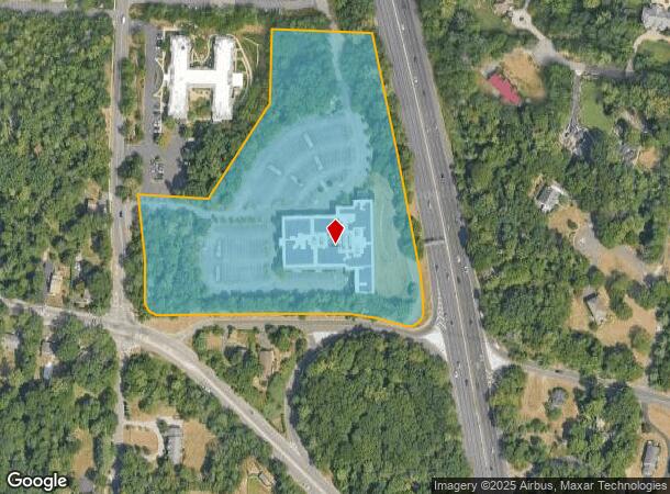
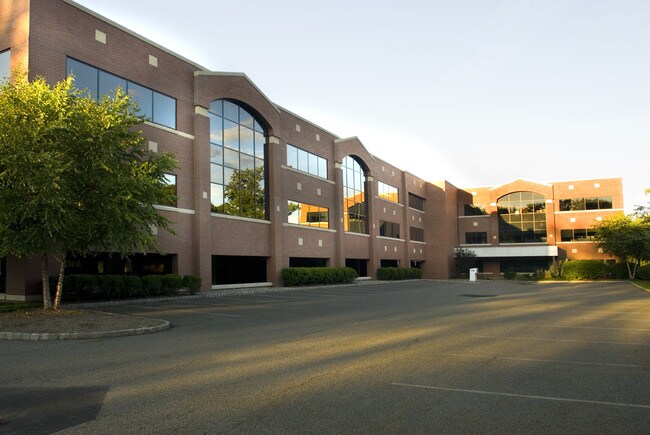
Property Record
1 State Rt 17 S, Saddle River, NJ 07458

NEARBY LISTINGS FOR SALE OR LEASE
Property Detail
1 State Rt 17 S
New York-Jersey City-White Plains, NY-NJ
Final Subdivision Plat Section 2
58-01302-0000-00001-04
9.45 AC.
Commercialnec
Bergen
X
New Jersey
34003C0086J
1.4
2024
9.45 AC
2025
North 17 Corridor
053100
Northern New Jersey
DEMOGRAPHICS near 1 State Rt 17 S
1 Mile
3 Mile
5 Mile
2024 Total Population
4,550
65,726
204,355
2029 Population
4,545
65,945
204,364
Pop Growth 2024-2029
(0.11%)
+ 0.33%
0.00%
Average Age
45
42
42
2024 Total Households
1,587
22,877
71,434
HH Growth 2024-2029
(0.19%)
+ 0.25%
(0.05%)
Median Household Inc
$149,491
$167,088
$145,594
Avg Household Size
2.70
2.80
2.80
2024 Avg HH Vehicles
2.00
2.00
2.00
Median Home Value
$897,503
$768,892
$724,906
Median Year Built
1976
1965
1964
Nearby Places
Map Layers
Map Styles
 Street
 Aerial
- Restaurants
- Banks
- Shops
- Fitness
- Groceries
PUBLIC TRANSPORTATION
COMMUTER RAIL
Allendale (Bergen County/Port Jervis Line - NJ Transit Commuter Rail (NJ Transit), Main/Port Jervis Line - NJ Transit Commuter Rail (NJ Transit))
DRIVE
WALK
Distance
Allendale (Bergen County/Port Jervis Line - NJ Transit Commuter Rail (NJ Transit), Main/Port Jervis Line - NJ Transit Commuter Rail (NJ Transit))
5 min
1.7 mi
Waldwick (Bergen County/Port Jervis Line - NJ Transit Commuter Rail (NJ Transit), Main/Port Jervis Line - NJ Transit Commuter Rail (NJ Transit))
DRIVE
WALK
Distance
Waldwick (Bergen County/Port Jervis Line - NJ Transit Commuter Rail (NJ Transit), Main/Port Jervis Line - NJ Transit Commuter Rail (NJ Transit))
5 min
2.4 mi
AIRPORT
LaGuardia
DRIVE
WALK
Distance
LaGuardia
43 min
27.9 mi
Newark Liberty International
DRIVE
WALK
Distance
Newark Liberty International
36 min
28.3 mi
Westchester County
DRIVE
WALK
Distance
Westchester County
50 min
32.2 mi
Freight Ports
Port Newark Container Terminal
DRIVE
WALK
Distance
Port Newark Container Terminal
43 min
29.9 mi
SALE & LEASE HISTORY
LISTING DATE
SALE/LEASE

Jul 16, 2020
For Lease
Nearby Properties
Address
Land Use
TOTAL SIZE
Lot Size
Zoning
Address
Land Use
TOTAL SIZE
Lot Size
Zoning
28.44 AC
Address
Land Use
TOTAL SIZE
Lot Size
Zoning
131,384 SF
65 AC
EO
Address
Land Use
TOTAL SIZE
Lot Size
Zoning
Address
Land Use
TOTAL SIZE
Lot Size
Zoning
205,580 SF
21.18 AC
EO
Address
Land Use
TOTAL SIZE
Lot Size
Zoning
40.40 AC
PU
Address
Land Use
TOTAL SIZE
Lot Size
Zoning
17.71 AC
B3
Address
Land Use
TOTAL SIZE
Lot Size
Zoning
7.11 AC
Address
Land Use
TOTAL SIZE
Lot Size
Zoning
7.04 AC
SED
Address
Land Use
TOTAL SIZE
Lot Size
Zoning
Address
Land Use
TOTAL SIZE
Lot Size
Zoning
Address
Land Use
TOTAL SIZE
Lot Size
Zoning
80.80 AC
Address
Land Use
TOTAL SIZE
Lot Size
Zoning
23.19 AC
R1
Address
Land Use
TOTAL SIZE
Lot Size
Zoning
13 AC
EAO
Address
Land Use
TOTAL SIZE
Lot Size
Zoning
16.02 AC
R3
Address
Land Use
TOTAL SIZE
Lot Size
Zoning
22.75 AC
Address
Land Use
TOTAL SIZE
Lot Size
Zoning
9.29 AC
SED
Address
Land Use
TOTAL SIZE
Lot Size
Zoning
17 AC
OR1
Address
Land Use
TOTAL SIZE
Lot Size
Zoning
36.49 AC
OR-2
Address
Land Use
TOTAL SIZE
Lot Size
Zoning
Address
Land Use
TOTAL SIZE
Lot Size
Zoning
20.30 AC
Address
Land Use
TOTAL SIZE
Lot Size
Zoning
31.79 AC
OR2
Address
Land Use
TOTAL SIZE
Lot Size
Zoning
3,165 SF
2.07 AC
VC2
Address
Land Use
TOTAL SIZE
Lot Size
Zoning
Address
Land Use
TOTAL SIZE
Lot Size
Zoning
38.65 AC
Address
Land Use
TOTAL SIZE
Lot Size
Zoning
10.38 AC
Address
Land Use
TOTAL SIZE
Lot Size
Zoning
10.64 AC
AAA
Address
Land Use
TOTAL SIZE
Lot Size
Zoning
6.52 AC
Address
Land Use
TOTAL SIZE
Lot Size
Zoning
2,374 SF
1.80 AC
SOII
Address
Land Use
TOTAL SIZE
Lot Size
Zoning
17.90 AC
IP
Address
Land Use
TOTAL SIZE
Lot Size
Zoning
71,166 SF
7.26 AC
B3
The World's #1 Commercial Real Estate Marketplace
Connect with us
© 2025 CoStar Group
The information above has been obtained from sources believed reliable. While we do not doubt its accuracy we have not verified it and make no guarantee, warranty or representation about it. It is your responsibility to independently confirm its accuracy and completeness. Any projections, opinions, assumptions, or estimates used are for example only and do not represent the current or future performance of the property. The value of this transaction to you depends on tax and other factors which should be evaluated by your tax, financial, and legal advisors. You and your advisors should conduct a careful, independent investigation of the property to determine to your satisfaction the suitability of the property for your needs.