Property Record
1 Station St, Hingham, MA 02043
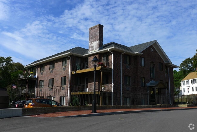

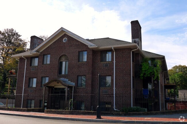
Property Detail
1 Station St
HING-000061-000000-000076
Plymouth
Apartment
Massachusetts
AE The base floodplain where base flood elevations are provided. AE Zones are now used on new format FIRMs instead of A1-A30 Zones.
76
2025
0.54 AC
2025
South Shore-Plymouth
501101
Boston
19,865 SF
Boston-Cambridge-Newton, MA-NH
NEARBY LISTINGS FOR SALE OR LEASE
DEMOGRAPHICS near 1 Station St
1 mile
3 mile
5 mile
2025 Total Population
5,125
35,583
110,240
2030 Population
5,275
36,611
113,239
Pop Growth 2025-2030
+ 2.93%
+ 2.89%
+ 2.72%
Average Age
41
44
44
2025 Total Households
1,839
14,326
46,147
HH Growth 2025-2030
+ 2.77%
+ 3.03%
+ 2.78%
Median Household Inc
$203,739
$144,554
$111,835
Avg Household Size
2.70
2.40
2.30
2025 Avg HH Vehicles
2.00
2.00
2.00
Median Home Value
$1,100,595
$880,449
$745,599
Median Year Built
1956
1962
1960
Nearby Places
Map Layers
Map Styles
 Street
 Aerial
Transit
 Traffic
 Biking
Places
Listings with unknown addresses are not visible on the map
- Restaurants
- Banks
- Shops
- Fitness
- Groceries
PUBLIC TRANSPORTATION
COMMUTER RAIL
West Hingham (Greenbush Line - Massachusetts Bay Transportation Authority Commuter Rail (Purple Line))
Drive
Walk
Distance
West Hingham (Greenbush Line - Massachusetts Bay Transportation Authority Commuter Rail (Purple Line))
3 min
1.2 mi
Nantasket Junction (Greenbush Line - Massachusetts Bay Transportation Authority Commuter Rail (Purple Line))
Drive
Walk
Distance
Nantasket Junction (Greenbush Line - Massachusetts Bay Transportation Authority Commuter Rail (Purple Line))
3 min
1.3 mi
AIRPORT
General Edward Lawrence Logan International
Drive
Walk
Distance
General Edward Lawrence Logan International
34 min
17.8 mi
Freight Ports
Port of Boston
Drive
Walk
Distance
Port of Boston
30 min
15.4 mi
Nearby Properties
Address
Land Use
TOTAL SIZE
Lot Size
Zoning
Address
Land Use
TOTAL SIZE
Lot Size
Zoning
233,488 SF
9.82 AC
Address
Land Use
TOTAL SIZE
Lot Size
Zoning
229,928 SF
3.79 AC
Address
Land Use
TOTAL SIZE
Lot Size
Zoning
193,216 SF
11.98 AC
MFA
Address
Land Use
TOTAL SIZE
Lot Size
Zoning
9.94 AC
Address
Land Use
TOTAL SIZE
Lot Size
Zoning
231,358 SF
40.22 AC
Address
Land Use
TOTAL SIZE
Lot Size
Zoning
177,187 SF
49.76 AC
Address
Land Use
TOTAL SIZE
Lot Size
Zoning
79,687 SF
3.52 AC
75
Address
Land Use
TOTAL SIZE
Lot Size
Zoning
8.96 AC
Address
Land Use
TOTAL SIZE
Lot Size
Zoning
90,325 SF
11.64 AC
Address
Land Use
TOTAL SIZE
Lot Size
Zoning
21.75 AC
100
Address
Land Use
TOTAL SIZE
Lot Size
Zoning
127,267 SF
2.96 AC
Address
Land Use
TOTAL SIZE
Lot Size
Zoning
154.20 AC
Address
Land Use
TOTAL SIZE
Lot Size
Zoning
10,000 SF
21.60 AC
Address
Land Use
TOTAL SIZE
Lot Size
Zoning
78,912 SF
6.56 AC
Address
Land Use
TOTAL SIZE
Lot Size
Zoning
8.76 AC
Address
Land Use
TOTAL SIZE
Lot Size
Zoning
8.60 AC
Address
Land Use
TOTAL SIZE
Lot Size
Zoning
1,450.92 AC
Address
Land Use
TOTAL SIZE
Lot Size
Zoning
472.26 AC
Address
Land Use
TOTAL SIZE
Lot Size
Zoning
79,203 SF
1.24 AC
BUS
Address
Land Use
TOTAL SIZE
Lot Size
Zoning
137.65 AC
100
Address
Land Use
TOTAL SIZE
Lot Size
Zoning
10.61 AC
Address
Land Use
TOTAL SIZE
Lot Size
Zoning
4.30 AC
100
Address
Land Use
TOTAL SIZE
Lot Size
Zoning
13.46 AC
TECH
Address
Land Use
TOTAL SIZE
Lot Size
Zoning
62,663 SF
39.75 AC
Address
Land Use
TOTAL SIZE
Lot Size
Zoning
75,870 SF
28.30 AC
Address
Land Use
TOTAL SIZE
Lot Size
Zoning
68,507 SF
2.90 AC
TECH
Address
Land Use
TOTAL SIZE
Lot Size
Zoning
63,372 SF
5.02 AC
LI
Address
Land Use
TOTAL SIZE
Lot Size
Zoning
45,369 SF
1.81 AC
Address
Land Use
TOTAL SIZE
Lot Size
Zoning
19,146 SF
122.83 AC
RC
Address
Land Use
TOTAL SIZE
Lot Size
Zoning
46,800 SF
7.46 AC
100
The World's #1 Commercial Real Estate Marketplace
Connect with us
© 2026 CoStar Group
The information above has been obtained from sources believed reliable. While we do not doubt its accuracy we have not verified it and make no guarantee, warranty or representation about it. It is your responsibility to independently confirm its accuracy and completeness. Any projections, opinions, assumptions, or estimates used are for example only and do not represent the current or future performance of the property. The value of this transaction to you depends on tax and other factors which should be evaluated by your tax, financial, and legal advisors. You and your advisors should conduct a careful, independent investigation of the property to determine to your satisfaction the suitability of the property for your needs.