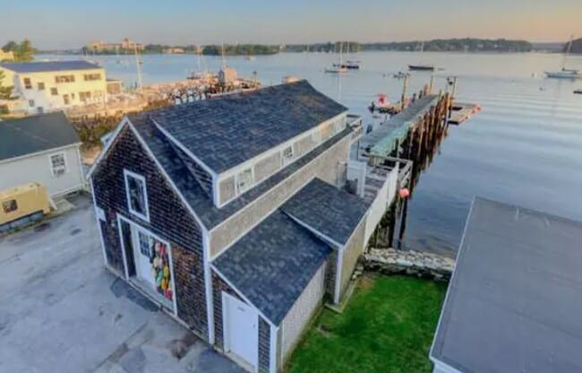
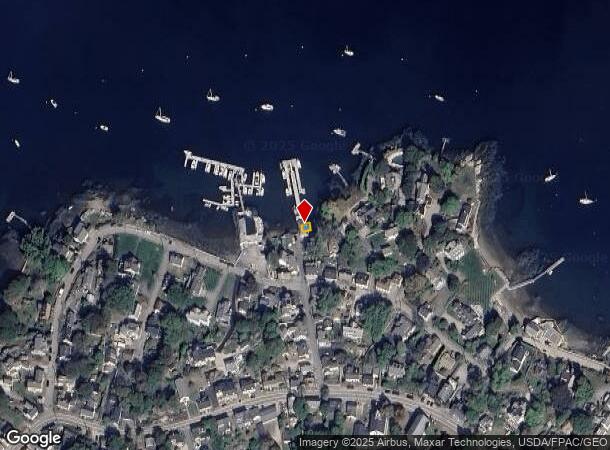
Property Record
1 Steamboat Ln, New Castle, NH 03854
NEARBY LISTINGS FOR SALE OR LEASE
-
-
-
-
-
-
No Photo
-
-
View all New Castle listings for sale on LoopNet.com
Property Detail
1 Steamboat Ln
Commercialbuilding
Rockingham
AE
New Hampshire
23031C0729G
0.01 AC
2024
Rockingham
2024
Boston
069700
Boston-Cambridge-Newton, MA-NH
1,588 SF
NCAS-000018-000016
DEMOGRAPHICS near 1 Steamboat Ln
1 Mile
3 Mile
5 Mile
2024 Total Population
1,182
21,454
40,557
2029 Population
1,220
22,499
42,540
Pop Growth 2024-2029
+ 3.21%
+ 4.87%
+ 4.89%
Average Age
53
45
45
2024 Total Households
539
10,234
18,529
HH Growth 2024-2029
+ 2.97%
+ 4.83%
+ 4.84%
Median Household Inc
$134,615
$98,795
$98,467
Avg Household Size
2.20
2.00
2.10
2024 Avg HH Vehicles
2.00
2.00
2.00
Median Home Value
$1,047,575
$654,184
$558,407
Median Year Built
1966
1951
1965
Nearby Places
Map Layers
Map Styles
 Street
 Aerial
- Restaurants
- Banks
- Shops
- Fitness
- Groceries
PUBLIC TRANSPORTATION
AIRPORT
Portsmouth International at Pease
DRIVE
WALK
Distance
Portsmouth International at Pease
19 min
6.6 mi
Freight Ports
Portland, ME
DRIVE
WALK
Distance
Portland, ME
69 min
54.0 mi
Nearby Properties
Address
Land Use
TOTAL SIZE
Lot Size
Zoning
Address
Land Use
TOTAL SIZE
Lot Size
Zoning
54.20 AC
M
Address
Land Use
TOTAL SIZE
Lot Size
Zoning
6.20 AC
G1
Address
Land Use
TOTAL SIZE
Lot Size
Zoning
138,881 SF
7.54 AC
PD PL
Address
Land Use
TOTAL SIZE
Lot Size
Zoning
152,028 SF
CD5
Address
Land Use
TOTAL SIZE
Lot Size
Zoning
144,226 SF
5.72 AC
M
Address
Land Use
TOTAL SIZE
Lot Size
Zoning
Address
Land Use
TOTAL SIZE
Lot Size
Zoning
22.33 AC
MU-N
Address
Land Use
TOTAL SIZE
Lot Size
Zoning
1,288 AC
GBW
Address
Land Use
TOTAL SIZE
Lot Size
Zoning
102,617 SF
1.27 AC
CD5
Address
Land Use
TOTAL SIZE
Lot Size
Zoning
57,711 SF
1.44 AC
CD4
Address
Land Use
TOTAL SIZE
Lot Size
Zoning
136,711 SF
1.85 AC
CD5
Address
Land Use
TOTAL SIZE
Lot Size
Zoning
4.73 AC
CD4-W
Address
Land Use
TOTAL SIZE
Lot Size
Zoning
15,546 SF
137.50 AC
P+C
Address
Land Use
TOTAL SIZE
Lot Size
Zoning
86,293 SF
0.64 AC
CD5
Address
Land Use
TOTAL SIZE
Lot Size
Zoning
15.20 AC
G1
Address
Land Use
TOTAL SIZE
Lot Size
Zoning
77,523 SF
CD5
Address
Land Use
TOTAL SIZE
Lot Size
Zoning
69,457 SF
0.98 AC
CD5
Address
Land Use
TOTAL SIZE
Lot Size
Zoning
58,070 SF
0.53 AC
CD4
Address
Land Use
TOTAL SIZE
Lot Size
Zoning
61,496 SF
17.59 AC
M
Address
Land Use
TOTAL SIZE
Lot Size
Zoning
112,872 SF
9.43 AC
G1
Address
Land Use
TOTAL SIZE
Lot Size
Zoning
2.67 AC
CD4-W
Address
Land Use
TOTAL SIZE
Lot Size
Zoning
8.04 AC
M
Address
Land Use
TOTAL SIZE
Lot Size
Zoning
278,670 SF
1.86 AC
M
Address
Land Use
TOTAL SIZE
Lot Size
Zoning
12,905 SF
32.28 AC
SA S
Address
Land Use
TOTAL SIZE
Lot Size
Zoning
57,456 SF
0.31 AC
CD5
Address
Land Use
TOTAL SIZE
Lot Size
Zoning
92,943 SF
8.55 AC
C-1
Address
Land Use
TOTAL SIZE
Lot Size
Zoning
201,109 SF
35.12 AC
WI
Address
Land Use
TOTAL SIZE
Lot Size
Zoning
47,866 SF
CD5
Address
Land Use
TOTAL SIZE
Lot Size
Zoning
203,601 SF
2.64 AC
M
Address
Land Use
TOTAL SIZE
Lot Size
Zoning
48,626 SF
0.24 AC
CD5
The World's #1 Commercial Real Estate Marketplace
Connect with us
© 2025 CoStar Group
The information above has been obtained from sources believed reliable. While we do not doubt its accuracy we have not verified it and make no guarantee, warranty or representation about it. It is your responsibility to independently confirm its accuracy and completeness. Any projections, opinions, assumptions, or estimates used are for example only and do not represent the current or future performance of the property. The value of this transaction to you depends on tax and other factors which should be evaluated by your tax, financial, and legal advisors. You and your advisors should conduct a careful, independent investigation of the property to determine to your satisfaction the suitability of the property for your needs.