Property Record
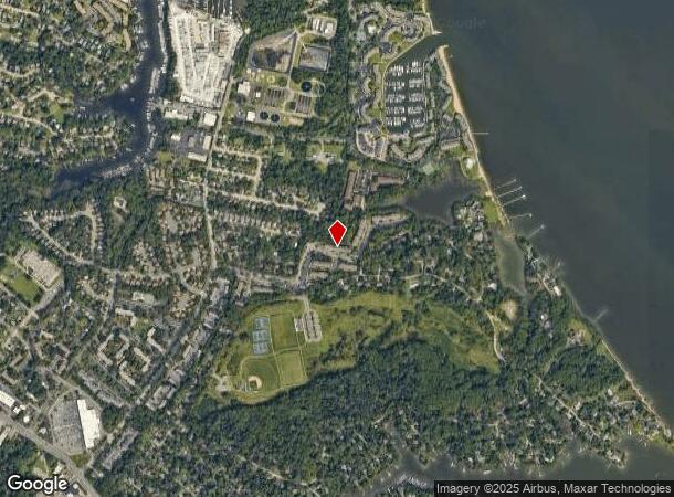
1 Tallwood Rd, Annapolis, MD 21403

NEARBY LISTINGS FOR SALE OR LEASE
-
-
View all Annapolis listings for sale on LoopNet.com
Property Detail
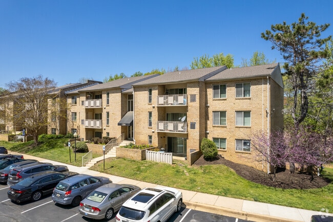
1 Tallwood Rd
Baltimore-Columbia-Towson, MD
Annapolis Roads Apts
06-000-00142916
8.78 AC SC 1 & 4.35 TALLWOOD RD ANNAPOLIS ROADS APTS
Apartment
Anne Arundel
X
Maryland
24003C0232F
1
2024
8.78 AC
2025
Annapolis
706302
Baltimore
DEMOGRAPHICS near 1 Tallwood Rd
1 Mile
3 Mile
5 Mile
2024 Total Population
9,621
49,569
91,226
2029 Population
9,976
51,232
93,980
Pop Growth 2024-2029
+ 3.69%
+ 3.35%
+ 3.02%
Average Age
44
41
42
2024 Total Households
4,599
20,511
37,357
HH Growth 2024-2029
+ 3.85%
+ 3.51%
+ 3.12%
Median Household Inc
$85,140
$102,363
$114,965
Avg Household Size
2.00
2.30
2.40
2024 Avg HH Vehicles
2.00
2.00
2.00
Median Home Value
$455,023
$590,773
$546,197
Median Year Built
1978
1975
1979
Nearby Places
Map Layers
Map Styles
 Street
 Aerial
- Restaurants
- Banks
- Shops
- Fitness
- Groceries
PUBLIC TRANSPORTATION
AIRPORT
Baltimore/Washington International Thurgood Marshall
DRIVE
WALK
Distance
Baltimore/Washington International Thurgood Marshall
40 min
26.3 mi
Freight Ports
Port of Baltimore
DRIVE
WALK
Distance
Port of Baltimore
47 min
31.8 mi
Nearby Properties
Address
Land Use
TOTAL SIZE
Lot Size
Zoning
Address
Land Use
TOTAL SIZE
Lot Size
Zoning
6,400 SF
31.17 AC
C1
Address
Land Use
TOTAL SIZE
Lot Size
Zoning
31.16 AC
R4
Address
Land Use
TOTAL SIZE
Lot Size
Zoning
434,112 SF
822.11 AC
R1
Address
Land Use
TOTAL SIZE
Lot Size
Zoning
406,976 SF
18.98 AC
R2
Address
Land Use
TOTAL SIZE
Lot Size
Zoning
58.99 AC
R2
Address
Land Use
TOTAL SIZE
Lot Size
Zoning
250,163 SF
2.19 AC
P
Address
Land Use
TOTAL SIZE
Lot Size
Zoning
198,795 SF
36 AC
R2
Address
Land Use
TOTAL SIZE
Lot Size
Zoning
248,820 SF
24.92 AC
R2
Address
Land Use
TOTAL SIZE
Lot Size
Zoning
309,756 SF
0.01 AC
R-22
Address
Land Use
TOTAL SIZE
Lot Size
Zoning
146,329 SF
1.26 AC
WMC
Address
Land Use
TOTAL SIZE
Lot Size
Zoning
272,275 SF
3.11 AC
P
Address
Land Use
TOTAL SIZE
Lot Size
Zoning
189,134 SF
1.02 AC
MX
Address
Land Use
TOTAL SIZE
Lot Size
Zoning
14.42 AC
R3
Address
Land Use
TOTAL SIZE
Lot Size
Zoning
117,577 SF
6.92 AC
R2
Address
Land Use
TOTAL SIZE
Lot Size
Zoning
37.74 AC
R3
Address
Land Use
TOTAL SIZE
Lot Size
Zoning
118,260 SF
34.01 AC
Address
Land Use
TOTAL SIZE
Lot Size
Zoning
199,311 SF
1 AC
MX
Address
Land Use
TOTAL SIZE
Lot Size
Zoning
233,141 SF
4.21 AC
MX
Address
Land Use
TOTAL SIZE
Lot Size
Zoning
114,102 SF
1.42 AC
P
Address
Land Use
TOTAL SIZE
Lot Size
Zoning
16.29 AC
R3
Address
Land Use
TOTAL SIZE
Lot Size
Zoning
Address
Land Use
TOTAL SIZE
Lot Size
Zoning
Address
Land Use
TOTAL SIZE
Lot Size
Zoning
Address
Land Use
TOTAL SIZE
Lot Size
Zoning
Address
Land Use
TOTAL SIZE
Lot Size
Zoning
Address
Land Use
TOTAL SIZE
Lot Size
Zoning
Address
Land Use
TOTAL SIZE
Lot Size
Zoning
Address
Land Use
TOTAL SIZE
Lot Size
Zoning
26.16 AC
Address
Land Use
TOTAL SIZE
Lot Size
Zoning
12.02 AC
R3
The World's #1 Commercial Real Estate Marketplace
Connect with us
© 2026 CoStar Group
The information above has been obtained from sources believed reliable. While we do not doubt its accuracy we have not verified it and make no guarantee, warranty or representation about it. It is your responsibility to independently confirm its accuracy and completeness. Any projections, opinions, assumptions, or estimates used are for example only and do not represent the current or future performance of the property. The value of this transaction to you depends on tax and other factors which should be evaluated by your tax, financial, and legal advisors. You and your advisors should conduct a careful, independent investigation of the property to determine to your satisfaction the suitability of the property for your needs.