Property Record
1 Tower Dr, Saugerties, NY 12477
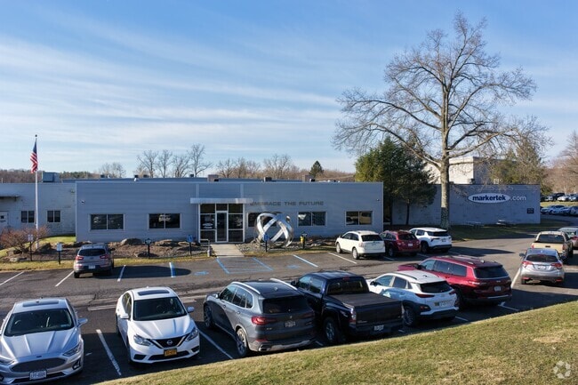


Property Detail
1 Tower Dr
4889-028.004-0002-007.000-0000
Ulster
Industrialgeneral
New York
02 - SINGL
7.000
B and X Area of moderate flood hazard, usually the area between the limits of the 100-year and 500-year floods.
14.20 AC
2025
Hudson Valley Area
2025
Other Market Areas
954900
Kingston, NY
117,450 SF
NEARBY LISTINGS FOR SALE OR LEASE
-
-
View all Saugerties listings for sale on LoopNet.com
DEMOGRAPHICS near 1 Tower Dr
1 mile
3 mile
5 mile
2025 Total Population
1,049
12,365
25,354
2030 Population
1,034
12,365
25,314
Pop Growth 2025-2030
(1.43%)
0.00%
(0.16%)
Average Age
43
44
45
2025 Total Households
433
5,301
10,622
HH Growth 2025-2030
(1.62%)
+ 0.08%
(0.14%)
Median Household Inc
$96,874
$79,394
$79,374
Avg Household Size
2.40
2.30
2.30
2025 Avg HH Vehicles
2.00
2.00
2.00
Median Home Value
$285,954
$333,567
$342,144
Median Year Built
1960
1967
1967
Nearby Places
Map Layers
Map Styles
 Street
 Aerial
Layers
 Traffic
 Biking
Places
Listings with unknown addresses are not visible on the map
- Restaurants
- Banks
- Shops
- Fitness
- Groceries
Nearby Properties
Address
Land Use
TOTAL SIZE
Lot Size
Zoning
Address
Land Use
TOTAL SIZE
Lot Size
Zoning
12,489 SF
15.10 AC
02 - SINGL
Address
Land Use
TOTAL SIZE
Lot Size
Zoning
Address
Land Use
TOTAL SIZE
Lot Size
Zoning
120 SF
56.32 AC
35
Address
Land Use
TOTAL SIZE
Lot Size
Zoning
7,994 SF
13.70 AC
23
Address
Land Use
TOTAL SIZE
Lot Size
Zoning
41,213 SF
7.90 AC
02
Address
Land Use
TOTAL SIZE
Lot Size
Zoning
56,845 SF
17.70 AC
02 - SINGL
Address
Land Use
TOTAL SIZE
Lot Size
Zoning
36,004 SF
7.10 AC
05 - COMME
Address
Land Use
TOTAL SIZE
Lot Size
Zoning
47,679 SF
14 AC
02 - SINGL
Address
Land Use
TOTAL SIZE
Lot Size
Zoning
9,524 SF
2 AC
02 - SINGL
Address
Land Use
TOTAL SIZE
Lot Size
Zoning
13,066 SF
149 AC
Address
Land Use
TOTAL SIZE
Lot Size
Zoning
6,144 SF
3.30 AC
02 - SINGL
Address
Land Use
TOTAL SIZE
Lot Size
Zoning
37,172 SF
10.10 AC
06 - INDUS
Address
Land Use
TOTAL SIZE
Lot Size
Zoning
18,225 SF
29.30 AC
02 - SINGL
Address
Land Use
TOTAL SIZE
Lot Size
Zoning
17,736 SF
1.40 AC
02 - SINGL
Address
Land Use
TOTAL SIZE
Lot Size
Zoning
8,064 SF
3.20 AC
05 - COMME
Address
Land Use
TOTAL SIZE
Lot Size
Zoning
12,088 SF
1.50 AC
05 - COMME
Address
Land Use
TOTAL SIZE
Lot Size
Zoning
74.30 AC
22
Address
Land Use
TOTAL SIZE
Lot Size
Zoning
3,151 SF
12.80 AC
05 - COMME
Address
Land Use
TOTAL SIZE
Lot Size
Zoning
3,648 SF
2.30 AC
02 - SINGL
Address
Land Use
TOTAL SIZE
Lot Size
Zoning
70.61 AC
22
Address
Land Use
TOTAL SIZE
Lot Size
Zoning
6,000 SF
6.10 AC
05 - COMME
Address
Land Use
TOTAL SIZE
Lot Size
Zoning
32,000 SF
11.90 AC
02 - SINGL
Address
Land Use
TOTAL SIZE
Lot Size
Zoning
1,680 SF
74.66 AC
23
Address
Land Use
TOTAL SIZE
Lot Size
Zoning
57,656 SF
6.30 AC
08 - GOVER
Address
Land Use
TOTAL SIZE
Lot Size
Zoning
1,311 SF
1.90 AC
05 - COMME
Address
Land Use
TOTAL SIZE
Lot Size
Zoning
6,800 SF
0.42 AC
07 - MIXED
Address
Land Use
TOTAL SIZE
Lot Size
Zoning
3,584 SF
1.80 AC
02 - SINGL
Address
Land Use
TOTAL SIZE
Lot Size
Zoning
61.40 AC
22
Address
Land Use
TOTAL SIZE
Lot Size
Zoning
39,067 SF
9.70 AC
02 - SINGL
The World's #1 Commercial Real Estate Marketplace
Connect with us
© 2026 CoStar Group
The information above has been obtained from sources believed reliable. While we do not doubt its accuracy we have not verified it and make no guarantee, warranty or representation about it. It is your responsibility to independently confirm its accuracy and completeness. Any projections, opinions, assumptions, or estimates used are for example only and do not represent the current or future performance of the property. The value of this transaction to you depends on tax and other factors which should be evaluated by your tax, financial, and legal advisors. You and your advisors should conduct a careful, independent investigation of the property to determine to your satisfaction the suitability of the property for your needs.