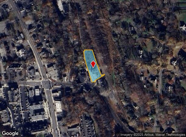
Property Record
1 Tucks Rd, Brookfield, CT 06804
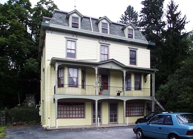
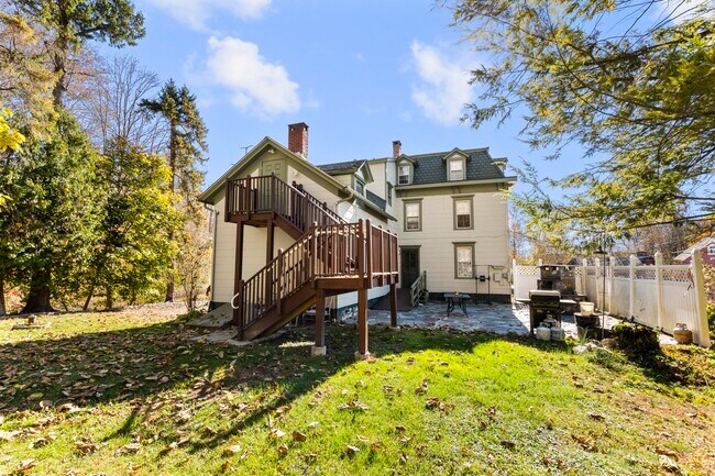
This Property Is For Sale
NEARBY LISTINGS FOR SALE OR LEASE
Property Detail
1 Tucks Rd
BROO-000007D-000000-000038
Fairfield
Commercialbuilding
Connecticut
X
38
09001C0131F
0.65 AC
2025
Danbury/Newtown/Monroe
2025
Westchester/So Connecticut
205200
Bridgeport-Stamford-Danbury, CT
4,607 SF
DEMOGRAPHICS near 1 Tucks Rd
1 Mile
3 Mile
5 Mile
2024 Total Population
3,371
21,717
54,286
2029 Population
3,379
22,000
54,888
Pop Growth 2024-2029
+ 0.24%
+ 1.30%
+ 1.11%
Average Age
42
43
43
2024 Total Households
1,278
8,302
20,360
HH Growth 2024-2029
+ 0.23%
+ 1.30%
+ 1.09%
Median Household Inc
$113,733
$122,586
$117,046
Avg Household Size
2.60
2.60
2.50
2024 Avg HH Vehicles
2.00
2.00
2.00
Median Home Value
$410,351
$414,133
$389,788
Median Year Built
1971
1973
1975
Nearby Places
Map Layers
Map Styles
 Street
 Aerial
- Restaurants
- Banks
- Shops
- Fitness
- Groceries
PUBLIC TRANSPORTATION
COMMUTER RAIL
Danbury Station (New Haven Line - Metro-North Commuter Railroad Company (Metro-North))
DRIVE
WALK
Distance
Danbury Station (New Haven Line - Metro-North Commuter Railroad Company (Metro-North))
15 min
7.8 mi
Bethel Station (New Haven Line - Metro-North Commuter Railroad Company (Metro-North))
DRIVE
WALK
Distance
Bethel Station (New Haven Line - Metro-North Commuter Railroad Company (Metro-North))
20 min
9.1 mi
AIRPORT
Tweed/New Haven
DRIVE
WALK
Distance
Tweed/New Haven
70 min
37.7 mi
Westchester County
DRIVE
WALK
Distance
Westchester County
56 min
41.5 mi
Nearby Properties
Address
Land Use
TOTAL SIZE
Lot Size
Zoning
Address
Land Use
TOTAL SIZE
Lot Size
Zoning
168,282 SF
22.83 AC
R-60
Address
Land Use
TOTAL SIZE
Lot Size
Zoning
79.31 AC
R-80
Address
Land Use
TOTAL SIZE
Lot Size
Zoning
4.09 AC
C-1
Address
Land Use
TOTAL SIZE
Lot Size
Zoning
9.39 AC
C-2
Address
Land Use
TOTAL SIZE
Lot Size
Zoning
16.31 AC
C-1
Address
Land Use
TOTAL SIZE
Lot Size
Zoning
45.15 AC
I-1 HO
Address
Land Use
TOTAL SIZE
Lot Size
Zoning
77,492 SF
30.25 AC
Address
Land Use
TOTAL SIZE
Lot Size
Zoning
65,027 SF
5.69 AC
C-1
Address
Land Use
TOTAL SIZE
Lot Size
Zoning
2,173 SF
4.76 AC
TCD
Address
Land Use
TOTAL SIZE
Lot Size
Zoning
53,582 SF
7.71 AC
C-2
Address
Land Use
TOTAL SIZE
Lot Size
Zoning
6.54 AC
TCD-P
Address
Land Use
TOTAL SIZE
Lot Size
Zoning
151,200 SF
12.48 AC
I-1
Address
Land Use
TOTAL SIZE
Lot Size
Zoning
6.87 AC
C-1
Address
Land Use
TOTAL SIZE
Lot Size
Zoning
110,200 SF
4.96 AC
I-1 HO
Address
Land Use
TOTAL SIZE
Lot Size
Zoning
9.29 AC
R-60
Address
Land Use
TOTAL SIZE
Lot Size
Zoning
57,782 SF
7.14 AC
R-80
Address
Land Use
TOTAL SIZE
Lot Size
Zoning
54.60 AC
R-80
Address
Land Use
TOTAL SIZE
Lot Size
Zoning
4.65 AC
TCD
Address
Land Use
TOTAL SIZE
Lot Size
Zoning
60,042 SF
7.20 AC
TCD
Address
Land Use
TOTAL SIZE
Lot Size
Zoning
29,862 SF
1.41 AC
TCD
Address
Land Use
TOTAL SIZE
Lot Size
Zoning
58,880 SF
4.08 AC
C-1
Address
Land Use
TOTAL SIZE
Lot Size
Zoning
10.07 AC
I-1
Address
Land Use
TOTAL SIZE
Lot Size
Zoning
17,044 SF
7.36 AC
RA40
Address
Land Use
TOTAL SIZE
Lot Size
Zoning
4.80 AC
I-1
Address
Land Use
TOTAL SIZE
Lot Size
Zoning
99,524 SF
9.41 AC
I-1
Address
Land Use
TOTAL SIZE
Lot Size
Zoning
30.50 AC
RA-20
Address
Land Use
TOTAL SIZE
Lot Size
Zoning
2,400 SF
1,190.70 AC
R80
Address
Land Use
TOTAL SIZE
Lot Size
Zoning
1.92 AC
MC
Address
Land Use
TOTAL SIZE
Lot Size
Zoning
36,239 SF
5.93 AC
C-2
Address
Land Use
TOTAL SIZE
Lot Size
Zoning
26.25 AC
RR3
The World's #1 Commercial Real Estate Marketplace
Connect with us
© 2026 CoStar Group
The information above has been obtained from sources believed reliable. While we do not doubt its accuracy we have not verified it and make no guarantee, warranty or representation about it. It is your responsibility to independently confirm its accuracy and completeness. Any projections, opinions, assumptions, or estimates used are for example only and do not represent the current or future performance of the property. The value of this transaction to you depends on tax and other factors which should be evaluated by your tax, financial, and legal advisors. You and your advisors should conduct a careful, independent investigation of the property to determine to your satisfaction the suitability of the property for your needs.