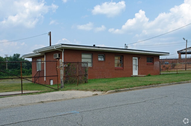
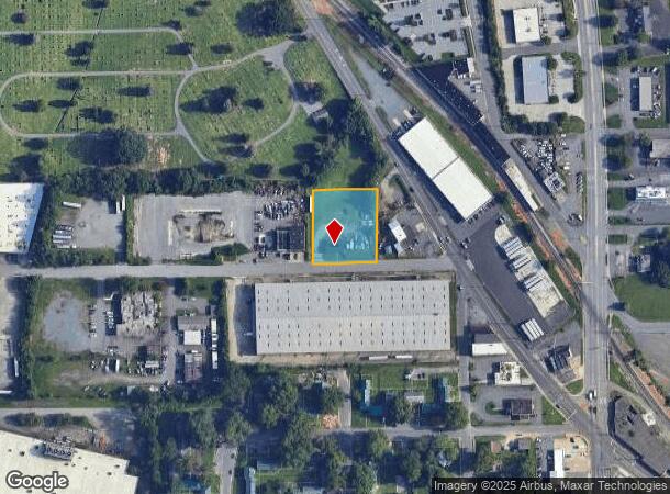
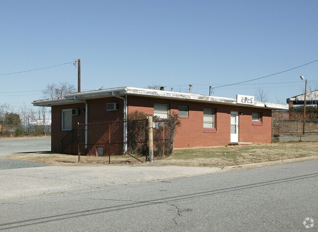
Property Record
1 W 32Nd St, Winston Salem, NC 27105
NEARBY LISTINGS FOR SALE OR LEASE
Property Detail
1 W 32Nd St
Winston-Salem, NC
Epes Trucking Company
6836-29-4494
EPES TRUCKING COMPANY LO:056 BL:1745 BU:1
Commercialnec
Forsyth
X
North Carolina
3710683600J
56
2023
0.90 AC
2025
NE Forsyth County
001400
Greensboro/Winston-Salem
1,350 SF
DEMOGRAPHICS near 1 W 32Nd St
1 Mile
3 Mile
5 Mile
2024 Total Population
5,764
66,616
143,395
2029 Population
6,079
69,914
149,852
Pop Growth 2024-2029
+ 5.46%
+ 4.95%
+ 4.50%
Average Age
35
37
38
2024 Total Households
2,063
27,126
58,353
HH Growth 2024-2029
+ 5.57%
+ 5.27%
+ 4.66%
Median Household Inc
$27,462
$40,754
$47,224
Avg Household Size
2.60
2.20
2.20
2024 Avg HH Vehicles
1.00
1.00
2.00
Median Home Value
$88,100
$162,367
$191,722
Median Year Built
1964
1971
1972
Nearby Places
Map Layers
Map Styles
 Street
 Aerial
- Restaurants
- Banks
- Shops
- Fitness
- Groceries
PUBLIC TRANSPORTATION
AIRPORT
Piedmont Triad International
DRIVE
WALK
Distance
Piedmont Triad International
37 min
25.7 mi
SALE & LEASE HISTORY
LISTING DATE
SALE/LEASE

Sep 25, 2016
For Lease
Sep 23, 2016
For Sale
Jan 07, 2020
For Lease
Nearby Properties
Address
Land Use
TOTAL SIZE
Lot Size
Zoning
Address
Land Use
TOTAL SIZE
Lot Size
Zoning
100 SF
213.71 AC
C
Address
Land Use
TOTAL SIZE
Lot Size
Zoning
368,715 SF
4.11 AC
CI
Address
Land Use
TOTAL SIZE
Lot Size
Zoning
205,729 SF
2.35 AC
CI
Address
Land Use
TOTAL SIZE
Lot Size
Zoning
244,516 SF
4.42 AC
CI
Address
Land Use
TOTAL SIZE
Lot Size
Zoning
297,475 SF
3.06 AC
CI-S
Address
Land Use
TOTAL SIZE
Lot Size
Zoning
315,590 SF
2 AC
CB
Address
Land Use
TOTAL SIZE
Lot Size
Zoning
156,507 SF
NULL
Address
Land Use
TOTAL SIZE
Lot Size
Zoning
121,886 SF
3.92 AC
PB-S
Address
Land Use
TOTAL SIZE
Lot Size
Zoning
436,579 SF
72.65 AC
RM8-S
Address
Land Use
TOTAL SIZE
Lot Size
Zoning
202,752 SF
3.43 AC
PB-L
Address
Land Use
TOTAL SIZE
Lot Size
Zoning
329,963 SF
58.84 AC
RM18-S
Address
Land Use
TOTAL SIZE
Lot Size
Zoning
352,549 SF
2.30 AC
CB WO
Address
Land Use
TOTAL SIZE
Lot Size
Zoning
140,472 SF
1.33 AC
CB WO
Address
Land Use
TOTAL SIZE
Lot Size
Zoning
283,831 SF
559.85 AC
GI,RS9
Address
Land Use
TOTAL SIZE
Lot Size
Zoning
122,900 SF
49.54 AC
GB
Address
Land Use
TOTAL SIZE
Lot Size
Zoning
153,315 SF
2.07 AC
CI
Address
Land Use
TOTAL SIZE
Lot Size
Zoning
195,551 SF
2.07 AC
CI
Address
Land Use
TOTAL SIZE
Lot Size
Zoning
200 SF
8.16 AC
PB-S
Address
Land Use
TOTAL SIZE
Lot Size
Zoning
138,636 SF
6.34 AC
RMU-S
Address
Land Use
TOTAL SIZE
Lot Size
Zoning
154,655 SF
0.76 AC
CI
Address
Land Use
TOTAL SIZE
Lot Size
Zoning
153,937 SF
34.63 AC
RM12-S
Address
Land Use
TOTAL SIZE
Lot Size
Zoning
264,904 SF
21.63 AC
GB
Address
Land Use
TOTAL SIZE
Lot Size
Zoning
169,443 SF
33.02 AC
GB
Address
Land Use
TOTAL SIZE
Lot Size
Zoning
112,000 SF
15.57 AC
IP
Address
Land Use
TOTAL SIZE
Lot Size
Zoning
449,945 SF
20.96 AC
LI
Address
Land Use
TOTAL SIZE
Lot Size
Zoning
205,979 SF
1.73 AC
CB WO
Address
Land Use
TOTAL SIZE
Lot Size
Zoning
207,203 SF
4.26 AC
PB
Address
Land Use
TOTAL SIZE
Lot Size
Zoning
70,376 SF
2.86 AC
PB-S
Address
Land Use
TOTAL SIZE
Lot Size
Zoning
188,135 SF
8.65 AC
GO-S
Address
Land Use
TOTAL SIZE
Lot Size
Zoning
152,968 SF
32.40 AC
RM18
The World's #1 Commercial Real Estate Marketplace
Connect with us
© 2025 CoStar Group
The information above has been obtained from sources believed reliable. While we do not doubt its accuracy we have not verified it and make no guarantee, warranty or representation about it. It is your responsibility to independently confirm its accuracy and completeness. Any projections, opinions, assumptions, or estimates used are for example only and do not represent the current or future performance of the property. The value of this transaction to you depends on tax and other factors which should be evaluated by your tax, financial, and legal advisors. You and your advisors should conduct a careful, independent investigation of the property to determine to your satisfaction the suitability of the property for your needs.