Property Record
1 W Union St, Ashland, MA 01721
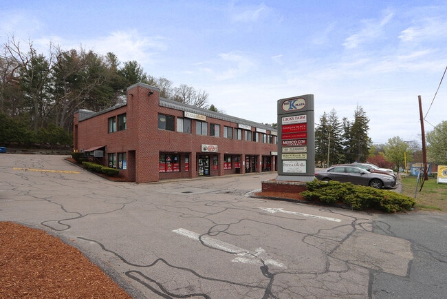

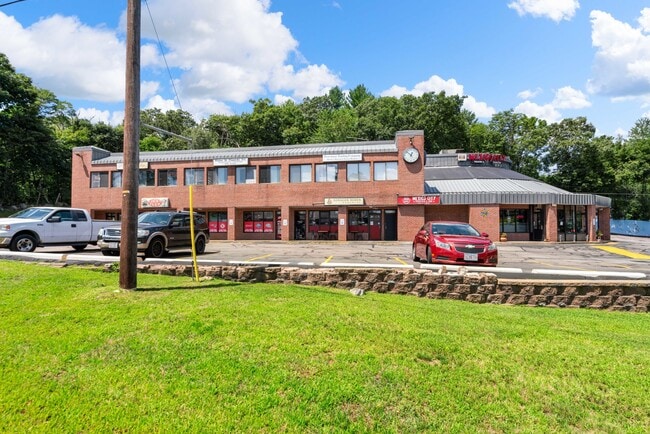
Property Detail
1 W Union St
Regionalshoppingcenterormallwithanchorstore
Middlesex
OT
Massachusetts
B and X Area of moderate flood hazard, usually the area between the limits of the 100-year and 500-year floods.
0.75 AC
2025
Hopkinton/Holliston
2025
Boston
385101
Boston-Cambridge-Newton, MA-NH
12,299 SF
ASHL-000020-000005
NEARBY LISTINGS FOR SALE OR LEASE
-
-
View all Ashland listings for lease on LoopNet.com
DEMOGRAPHICS near 1 W Union St
1 mile
3 mile
5 mile
2025 Total Population
7,220
47,635
125,406
2030 Population
7,495
49,760
130,912
Pop Growth 2025-2030
+ 3.81%
+ 4.46%
+ 4.39%
Average Age
42
40
40
2025 Total Households
2,736
18,246
46,758
HH Growth 2025-2030
+ 3.91%
+ 4.72%
+ 4.52%
Median Household Inc
$120,085
$123,580
$120,973
Avg Household Size
2.60
2.50
2.60
2025 Avg HH Vehicles
2.00
2.00
2.00
Median Home Value
$709,357
$700,378
$715,749
Median Year Built
1983
1978
1973
Nearby Places
Map Layers
Map Styles
 Street
 Aerial
Transit
 Traffic
 Biking
Places
Listings with unknown addresses are not visible on the map
- Restaurants
- Banks
- Shops
- Fitness
- Groceries
PUBLIC TRANSPORTATION
COMMUTER RAIL
Ashland (Framingham/Worcester Line - Massachusetts Bay Transportation Authority Commuter Rail (Purple Line))
Drive
Walk
Distance
Ashland (Framingham/Worcester Line - Massachusetts Bay Transportation Authority Commuter Rail (Purple Line))
6 min
1.2 mi
Framingham Amtrak (Lake Shore Limited - Amtrak)
Drive
Walk
Distance
Framingham Amtrak (Lake Shore Limited - Amtrak)
8 min
3.4 mi
AIRPORT
Worcester Regional
Drive
Walk
Distance
Worcester Regional
42 min
24.6 mi
General Edward Lawrence Logan International
Drive
Walk
Distance
General Edward Lawrence Logan International
46 min
28.3 mi
Freight Ports
Port of Boston
Drive
Walk
Distance
Port of Boston
45 min
26.7 mi
SALE & LEASE HISTORY
LISTING DATE
SALE/LEASE

May 07, 2022
For Lease
Aug 06, 2023
For Lease
Nearby Properties
Address
Land Use
TOTAL SIZE
Lot Size
Zoning
Address
Land Use
TOTAL SIZE
Lot Size
Zoning
556,849 SF
28.44 AC
R4
Address
Land Use
TOTAL SIZE
Lot Size
Zoning
51.50 AC
A2
Address
Land Use
TOTAL SIZE
Lot Size
Zoning
906,841 SF
47.93 AC
M1
Address
Land Use
TOTAL SIZE
Lot Size
Zoning
18.22 AC
OSMU
Address
Land Use
TOTAL SIZE
Lot Size
Zoning
340,840 SF
4.25 AC
B
Address
Land Use
TOTAL SIZE
Lot Size
Zoning
292,608 SF
5.19 AC
B
Address
Land Use
TOTAL SIZE
Lot Size
Zoning
293,180 SF
5.10 AC
B
Address
Land Use
TOTAL SIZE
Lot Size
Zoning
273,474 SF
7.46 AC
B
Address
Land Use
TOTAL SIZE
Lot Size
Zoning
191,520 SF
7.99 AC
B
Address
Land Use
TOTAL SIZE
Lot Size
Zoning
191,520 SF
5.03 AC
B
Address
Land Use
TOTAL SIZE
Lot Size
Zoning
244,033 SF
25.75 AC
R1
Address
Land Use
TOTAL SIZE
Lot Size
Zoning
108.84 AC
M
Address
Land Use
TOTAL SIZE
Lot Size
Zoning
139,356 SF
52 AC
30
Address
Land Use
TOTAL SIZE
Lot Size
Zoning
3.02 AC
CB
Address
Land Use
TOTAL SIZE
Lot Size
Zoning
112,000 SF
18.48 AC
R1
Address
Land Use
TOTAL SIZE
Lot Size
Zoning
150,636 SF
30.34 AC
GE
Address
Land Use
TOTAL SIZE
Lot Size
Zoning
154,724 SF
39.70 AC
R3
Address
Land Use
TOTAL SIZE
Lot Size
Zoning
289,642 SF
8.13 AC
M
Address
Land Use
TOTAL SIZE
Lot Size
Zoning
25.20 AC
A
Address
Land Use
TOTAL SIZE
Lot Size
Zoning
117,332 SF
3.02 AC
CB
Address
Land Use
TOTAL SIZE
Lot Size
Zoning
42,000 SF
3.82 AC
30
Address
Land Use
TOTAL SIZE
Lot Size
Zoning
149,806 SF
11.20 AC
B
Address
Land Use
TOTAL SIZE
Lot Size
Zoning
121,889 SF
2.01 AC
M1
Address
Land Use
TOTAL SIZE
Lot Size
Zoning
90,256 SF
14.48 AC
R4
Address
Land Use
TOTAL SIZE
Lot Size
Zoning
226,884 SF
6.16 AC
WMUSD
Address
Land Use
TOTAL SIZE
Lot Size
Zoning
113,540 SF
5.89 AC
CS
Address
Land Use
TOTAL SIZE
Lot Size
Zoning
71,070 SF
1.66 AC
R4
Address
Land Use
TOTAL SIZE
Lot Size
Zoning
85,380 SF
15.02 AC
R4
Address
Land Use
TOTAL SIZE
Lot Size
Zoning
84,260 SF
5.22 AC
M1
Address
Land Use
TOTAL SIZE
Lot Size
Zoning
71,500 SF
3.40 AC
30
The World's #1 Commercial Real Estate Marketplace
Connect with us
© 2026 CoStar Group
The information above has been obtained from sources believed reliable. While we do not doubt its accuracy we have not verified it and make no guarantee, warranty or representation about it. It is your responsibility to independently confirm its accuracy and completeness. Any projections, opinions, assumptions, or estimates used are for example only and do not represent the current or future performance of the property. The value of this transaction to you depends on tax and other factors which should be evaluated by your tax, financial, and legal advisors. You and your advisors should conduct a careful, independent investigation of the property to determine to your satisfaction the suitability of the property for your needs.