Property Record
1 Walnut St, Middleboro, MA 02346

NEARBY LISTINGS FOR SALE OR LEASE
-
-
View all Middleboro listings for sale on LoopNet.com
Property Detail
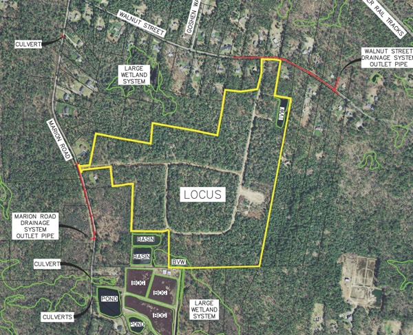
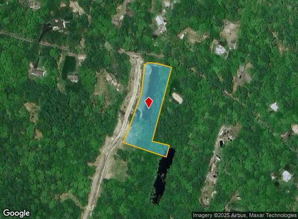
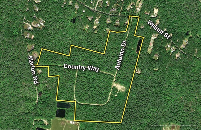
1 Walnut St
MIDD-000086-002125
Plymouth
Residentialacreage
Massachusetts
X
2125
25023C0451J
1.85 AC
2025
Route 3 South
2025
Boston
542102
Boston-Cambridge-Newton, MA-NH
DEMOGRAPHICS near 1 Walnut St
1 Mile
3 Mile
5 Mile
2024 Total Population
1,050
6,593
26,070
2029 Population
1,046
6,607
26,202
Pop Growth 2024-2029
(0.38%)
+ 0.21%
+ 0.51%
Average Age
43
42
42
2024 Total Households
384
2,386
9,901
HH Growth 2024-2029
(0.26%)
+ 0.21%
+ 0.42%
Median Household Inc
$87,701
$90,679
$89,275
Avg Household Size
2.70
2.70
2.60
2024 Avg HH Vehicles
2.00
2.00
2.00
Median Home Value
$432,168
$419,573
$431,619
Median Year Built
1982
1978
1973
Nearby Places
Map Layers
Map Styles
 Street
 Aerial
- Restaurants
- Banks
- Shops
- Fitness
- Groceries
PUBLIC TRANSPORTATION
COMMUTER RAIL
Middleborough/Lakeville (Middleborough/Lakeville Line - Massachusetts Bay Transportation Authority Commuter Rail (Purple Line))
DRIVE
WALK
Distance
Middleborough/Lakeville (Middleborough/Lakeville Line - Massachusetts Bay Transportation Authority Commuter Rail (Purple Line))
12 min
4.8 mi
AIRPORT
Rhode Island Tf Green International
DRIVE
WALK
Distance
Rhode Island Tf Green International
69 min
39.3 mi
Freight Ports
Port of New Bedford Harbor
DRIVE
WALK
Distance
Port of New Bedford Harbor
36 min
26.7 mi
SALE & LEASE HISTORY
LISTING DATE
SALE/LEASE

Feb 21, 2020
For Sale
Nearby Properties
Address
Land Use
TOTAL SIZE
Lot Size
Zoning
Address
Land Use
TOTAL SIZE
Lot Size
Zoning
167,715 SF
29.54 AC
Address
Land Use
TOTAL SIZE
Lot Size
Zoning
173,003 SF
26.10 AC
Address
Land Use
TOTAL SIZE
Lot Size
Zoning
48.30 AC
Address
Land Use
TOTAL SIZE
Lot Size
Zoning
128,922 SF
12.50 AC
Address
Land Use
TOTAL SIZE
Lot Size
Zoning
36.10 AC
Address
Land Use
TOTAL SIZE
Lot Size
Zoning
2,295.68 AC
Address
Land Use
TOTAL SIZE
Lot Size
Zoning
30,933 SF
12.67 AC
Address
Land Use
TOTAL SIZE
Lot Size
Zoning
54,000 SF
7 AC
Address
Land Use
TOTAL SIZE
Lot Size
Zoning
14.69 AC
Address
Land Use
TOTAL SIZE
Lot Size
Zoning
55,259 SF
7.49 AC
Address
Land Use
TOTAL SIZE
Lot Size
Zoning
7.74 AC
Address
Land Use
TOTAL SIZE
Lot Size
Zoning
38,204 SF
26.59 AC
Address
Land Use
TOTAL SIZE
Lot Size
Zoning
460 SF
12.67 AC
Address
Land Use
TOTAL SIZE
Lot Size
Zoning
Address
Land Use
TOTAL SIZE
Lot Size
Zoning
19,845 SF
15.21 AC
Address
Land Use
TOTAL SIZE
Lot Size
Zoning
16,410 SF
3.43 AC
Address
Land Use
TOTAL SIZE
Lot Size
Zoning
9,714 SF
3.25 AC
Address
Land Use
TOTAL SIZE
Lot Size
Zoning
16,716 SF
2.62 AC
Address
Land Use
TOTAL SIZE
Lot Size
Zoning
1.81 AC
Address
Land Use
TOTAL SIZE
Lot Size
Zoning
18.40 AC
Address
Land Use
TOTAL SIZE
Lot Size
Zoning
3.12 AC
Address
Land Use
TOTAL SIZE
Lot Size
Zoning
9,960 SF
10.77 AC
Address
Land Use
TOTAL SIZE
Lot Size
Zoning
1,320 SF
2.37 AC
Address
Land Use
TOTAL SIZE
Lot Size
Zoning
4,513 SF
1.59 AC
Address
Land Use
TOTAL SIZE
Lot Size
Zoning
291.70 AC
Address
Land Use
TOTAL SIZE
Lot Size
Zoning
2,790 SF
28.04 AC
Address
Land Use
TOTAL SIZE
Lot Size
Zoning
7,178 SF
4.56 AC
Address
Land Use
TOTAL SIZE
Lot Size
Zoning
16.24 AC
Address
Land Use
TOTAL SIZE
Lot Size
Zoning
Address
Land Use
TOTAL SIZE
Lot Size
Zoning
5,574 SF
21.60 AC
The World's #1 Commercial Real Estate Marketplace
Connect with us
© 2025 CoStar Group
The information above has been obtained from sources believed reliable. While we do not doubt its accuracy we have not verified it and make no guarantee, warranty or representation about it. It is your responsibility to independently confirm its accuracy and completeness. Any projections, opinions, assumptions, or estimates used are for example only and do not represent the current or future performance of the property. The value of this transaction to you depends on tax and other factors which should be evaluated by your tax, financial, and legal advisors. You and your advisors should conduct a careful, independent investigation of the property to determine to your satisfaction the suitability of the property for your needs.