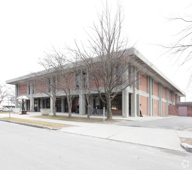
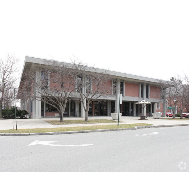
Property Record
1 Wendell Ave, Pittsfield, MA 01201

Save to a Folder
{{folder.Name}}
{{folder.ListingIds.length}} Properties
{{folder.ListingIds.length}} Property
Create a New Folder
Property Detail
1 Wendell Ave
PITT-000008H-000016-000015
Berkshire
Governmentalpublicusegeneral
Massachusetts
DCD
15
0
1.30 AC
2025
Other Market Areas
900100
Pittsfield, MA
NEARBY LISTINGS FOR SALE OR LEASE
-
-
View all Pittsfield listings for sale on LoopNet.com
DEMOGRAPHICS near 1 Wendell Ave
1 mile
3 mile
5 mile
2025 Total Population
14,840
37,198
47,962
2030 Population
14,378
36,067
46,695
Pop Growth 2025-2030
(3.11%)
(3.04%)
(2.64%)
Average Age
42
44
45
2025 Total Households
6,895
16,589
21,251
HH Growth 2025-2030
(3.02%)
(3.04%)
(2.63%)
Median Household Inc
$49,499
$70,223
$73,706
Avg Household Size
2.00
2.10
2.10
2025 Avg HH Vehicles
1.00
1.00
2.00
Median Home Value
$250,570
$253,365
$265,537
Median Year Built
1946
1948
1950
Nearby Places
Map Layers
Map Styles
 Street
 Aerial
Layers
 Traffic
 Biking
Places
Listings with unknown addresses are not visible on the map
- Restaurants
- Banks
- Shops
- Fitness
- Groceries
PUBLIC TRANSPORTATION
COMMUTER RAIL
Drive
Walk
Distance
2 min
8 min
0.4 mi
AIRPORT
Albany International
Drive
Walk
Distance
Albany International
73 min
45.6 mi
Freight Ports
Albany, NY Port
Drive
Walk
Distance
Albany, NY Port
63 min
40.2 mi
Nearby Properties
Address
Land Use
TOTAL SIZE
Lot Size
Zoning
Address
Land Use
TOTAL SIZE
Lot Size
Zoning
8.36 AC
BG
Address
Land Use
TOTAL SIZE
Lot Size
Zoning
363,252 SF
50 AC
R20
Address
Land Use
TOTAL SIZE
Lot Size
Zoning
284,301 SF
8.70 AC
DCD
Address
Land Use
TOTAL SIZE
Lot Size
Zoning
31.73 AC
R20
Address
Land Use
TOTAL SIZE
Lot Size
Zoning
Address
Land Use
TOTAL SIZE
Lot Size
Zoning
6.15 AC
IG
Address
Land Use
TOTAL SIZE
Lot Size
Zoning
165,400 SF
0.49 AC
IG
Address
Land Use
TOTAL SIZE
Lot Size
Zoning
334,640 SF
2.41 AC
DCD
Address
Land Use
TOTAL SIZE
Lot Size
Zoning
237.50 AC
R6
Address
Land Use
TOTAL SIZE
Lot Size
Zoning
21 AC
R12
Address
Land Use
TOTAL SIZE
Lot Size
Zoning
75.30 AC
R43
Address
Land Use
TOTAL SIZE
Lot Size
Zoning
130,904 SF
10.02 AC
R20
Address
Land Use
TOTAL SIZE
Lot Size
Zoning
88,685 SF
10.67 AC
R20
Address
Land Use
TOTAL SIZE
Lot Size
Zoning
41,395 SF
0.98 AC
BG
Address
Land Use
TOTAL SIZE
Lot Size
Zoning
82,292 SF
37.50 AC
R6
Address
Land Use
TOTAL SIZE
Lot Size
Zoning
2.38 AC
DCD
Address
Land Use
TOTAL SIZE
Lot Size
Zoning
286 AC
LDI
Address
Land Use
TOTAL SIZE
Lot Size
Zoning
1.30 AC
DCD
Address
Land Use
TOTAL SIZE
Lot Size
Zoning
29,700 SF
0.56 AC
DCD
Address
Land Use
TOTAL SIZE
Lot Size
Zoning
242,525 SF
12.52 AC
BC
Address
Land Use
TOTAL SIZE
Lot Size
Zoning
128,036 SF
14.92 AC
IG
Address
Land Use
TOTAL SIZE
Lot Size
Zoning
79,095 SF
14.89 AC
IG
Address
Land Use
TOTAL SIZE
Lot Size
Zoning
183,260 SF
6 AC
IG
Address
Land Use
TOTAL SIZE
Lot Size
Zoning
15 AC
R20
Address
Land Use
TOTAL SIZE
Lot Size
Zoning
17.26 AC
BG
Address
Land Use
TOTAL SIZE
Lot Size
Zoning
11.77 AC
IG
Address
Land Use
TOTAL SIZE
Lot Size
Zoning
37,551 SF
6.50 AC
R6
Address
Land Use
TOTAL SIZE
Lot Size
Zoning
102,954 SF
11.98 AC
IG
Address
Land Use
TOTAL SIZE
Lot Size
Zoning
49,209 SF
2.66 AC
RM
Address
Land Use
TOTAL SIZE
Lot Size
Zoning
225,775 SF
1.57 AC
BG
The World's #1 Commercial Real Estate Marketplace
Connect with us
© 2026 CoStar Group
The information above has been obtained from sources believed reliable. While we do not doubt its accuracy we have not verified it and make no guarantee, warranty or representation about it. It is your responsibility to independently confirm its accuracy and completeness. Any projections, opinions, assumptions, or estimates used are for example only and do not represent the current or future performance of the property. The value of this transaction to you depends on tax and other factors which should be evaluated by your tax, financial, and legal advisors. You and your advisors should conduct a careful, independent investigation of the property to determine to your satisfaction the suitability of the property for your needs.