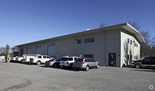
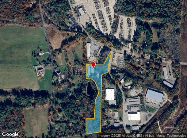
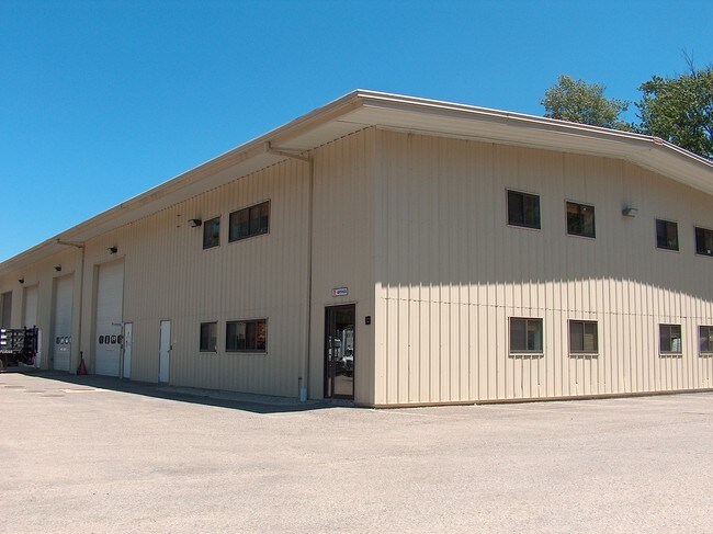
Property Record
1 William Way, Bellingham, MA 02019
NEARBY LISTINGS FOR SALE OR LEASE
Property Detail
1 William Way
BELL-000048-000005
Bellingham
Commercialbuilding
Norfolk
X
Massachusetts
25027C1055F
6.51 AC
2025
I-95 Corridor South
2025
Boston
443105
Boston-Cambridge-Newton, MA-NH
9,000 SF
DEMOGRAPHICS near 1 William Way
1 Mile
3 Mile
5 Mile
2024 Total Population
1,483
18,176
73,826
2029 Population
1,478
18,150
73,135
Pop Growth 2024-2029
(0.34%)
(0.14%)
(0.94%)
Average Age
42
42
41
2024 Total Households
565
6,944
27,705
HH Growth 2024-2029
(0.35%)
(0.14%)
(0.99%)
Median Household Inc
$113,541
$111,286
$107,841
Avg Household Size
2.60
2.60
2.60
2024 Avg HH Vehicles
2.00
2.00
2.00
Median Home Value
$451,807
$431,174
$425,300
Median Year Built
1981
1982
1973
Nearby Places
Map Layers
Map Styles
 Street
 Aerial
- Restaurants
- Banks
- Shops
- Fitness
- Groceries
PUBLIC TRANSPORTATION
COMMUTER RAIL
Forge Park/Route 495 (Franklin Line - Massachusetts Bay Transportation Authority Commuter Rail (Purple Line))
DRIVE
WALK
Distance
Forge Park/Route 495 (Franklin Line - Massachusetts Bay Transportation Authority Commuter Rail (Purple Line))
8 min
4.0 mi
Franklin (Franklin Line - Massachusetts Bay Transportation Authority Commuter Rail (Purple Line))
DRIVE
WALK
Distance
Franklin (Franklin Line - Massachusetts Bay Transportation Authority Commuter Rail (Purple Line))
11 min
5.8 mi
AIRPORT
Worcester Regional
DRIVE
WALK
Distance
Worcester Regional
50 min
28.9 mi
Rhode Island Tf Green International
DRIVE
WALK
Distance
Rhode Island Tf Green International
46 min
29.9 mi
Freight Ports
Port of Boston
DRIVE
WALK
Distance
Port of Boston
63 min
44.5 mi
Nearby Properties
Address
Land Use
TOTAL SIZE
Lot Size
Zoning
Address
Land Use
TOTAL SIZE
Lot Size
Zoning
20.97 AC
CRPC
Address
Land Use
TOTAL SIZE
Lot Size
Zoning
322,615 SF
17.33 AC
SUBN
Address
Land Use
TOTAL SIZE
Lot Size
Zoning
14.82 AC
AGR
Address
Land Use
TOTAL SIZE
Lot Size
Zoning
345,000 SF
60.44 AC
BUS1
Address
Land Use
TOTAL SIZE
Lot Size
Zoning
616,875 SF
141 AC
LI
Address
Land Use
TOTAL SIZE
Lot Size
Zoning
183,839 SF
39.29 AC
IND
Address
Land Use
TOTAL SIZE
Lot Size
Zoning
300,000 SF
64.63 AC
IND
Address
Land Use
TOTAL SIZE
Lot Size
Zoning
231,817 SF
35.01 AC
IND
Address
Land Use
TOTAL SIZE
Lot Size
Zoning
253,656 SF
44.84 AC
IND
Address
Land Use
TOTAL SIZE
Lot Size
Zoning
238,602 SF
109.37 AC
Address
Land Use
TOTAL SIZE
Lot Size
Zoning
238,975 SF
33.82 AC
IND
Address
Land Use
TOTAL SIZE
Lot Size
Zoning
451,000 SF
90.70 AC
IND
Address
Land Use
TOTAL SIZE
Lot Size
Zoning
75,140 SF
39.40 AC
Address
Land Use
TOTAL SIZE
Lot Size
Zoning
208,826 SF
18.96 AC
IND
Address
Land Use
TOTAL SIZE
Lot Size
Zoning
203,792 SF
27.93 AC
IND
Address
Land Use
TOTAL SIZE
Lot Size
Zoning
120,327 SF
28.75 AC
BUS2
Address
Land Use
TOTAL SIZE
Lot Size
Zoning
127,500 SF
22.01 AC
IND
Address
Land Use
TOTAL SIZE
Lot Size
Zoning
113,044 SF
71.52 AC
B
Address
Land Use
TOTAL SIZE
Lot Size
Zoning
51.71 AC
CRPC
Address
Land Use
TOTAL SIZE
Lot Size
Zoning
124,320 SF
10 AC
BUS1
Address
Land Use
TOTAL SIZE
Lot Size
Zoning
272,941 SF
34.05 AC
IB
Address
Land Use
TOTAL SIZE
Lot Size
Zoning
112,894 SF
9.96 AC
Address
Land Use
TOTAL SIZE
Lot Size
Zoning
111,100 SF
17.98 AC
IND
Address
Land Use
TOTAL SIZE
Lot Size
Zoning
109,838 SF
18.63 AC
Address
Land Use
TOTAL SIZE
Lot Size
Zoning
154,000 SF
21.92 AC
Address
Land Use
TOTAL SIZE
Lot Size
Zoning
115,908 SF
58.86 AC
IND
Address
Land Use
TOTAL SIZE
Lot Size
Zoning
128,693 SF
28.30 AC
Address
Land Use
TOTAL SIZE
Lot Size
Zoning
79,522 SF
24.21 AC
CRPC
Address
Land Use
TOTAL SIZE
Lot Size
Zoning
115,225 SF
10.79 AC
M
Address
Land Use
TOTAL SIZE
Lot Size
Zoning
143,208 SF
23.22 AC
The World's #1 Commercial Real Estate Marketplace
Connect with us
© 2025 CoStar Group
The information above has been obtained from sources believed reliable. While we do not doubt its accuracy we have not verified it and make no guarantee, warranty or representation about it. It is your responsibility to independently confirm its accuracy and completeness. Any projections, opinions, assumptions, or estimates used are for example only and do not represent the current or future performance of the property. The value of this transaction to you depends on tax and other factors which should be evaluated by your tax, financial, and legal advisors. You and your advisors should conduct a careful, independent investigation of the property to determine to your satisfaction the suitability of the property for your needs.