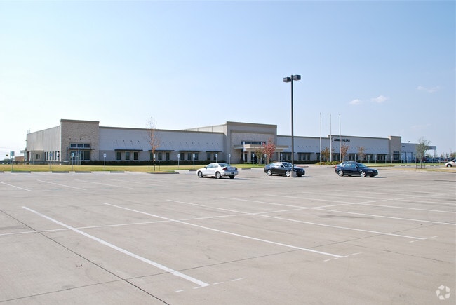
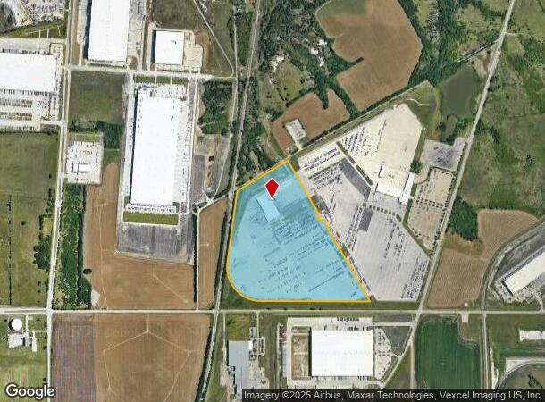
Property Record
1 Witt Rd, Lancaster, TX 75134


NEARBY LISTINGS FOR SALE OR LEASE
Property Detail
1 Witt Rd
Dallas-Fort Worth-Arlington, TX
Dlh Hutchins Wintergreen 178
300085500A0010000
DLH HUTCHINS WINTERGREEN 178 BLK A LT 1 ACS 63.090 INT201900051678 DD03012019 CO-DC 0085500A00100 4CU0085500A
Warehouse
Dallas
X
Texas
48113C0655K
1
2024
63.09 AC
2025
Lancaster
016704
Dallas/Ft Worth
107,412 SF
DEMOGRAPHICS near 1 Witt Rd
1 Mile
3 Mile
5 Mile
2024 Total Population
180
32,071
82,949
2029 Population
185
31,808
82,891
Pop Growth 2024-2029
+ 2.78%
(0.82%)
(0.07%)
Average Age
29
36
36
2024 Total Households
58
10,389
26,176
HH Growth 2024-2029
+ 1.72%
(1.07%)
(0.35%)
Median Household Inc
$22,500
$52,320
$50,354
Avg Household Size
3.00
3.00
3.00
2024 Avg HH Vehicles
1.00
2.00
2.00
Median Home Value
$199,999
$158,447
$159,105
Median Year Built
1999
1985
1989
Nearby Places
Map Layers
Map Styles
 Street
 Aerial
- Restaurants
- Banks
- Shops
- Fitness
- Groceries
PUBLIC TRANSPORTATION
AIRPORT
Dallas Love Field
DRIVE
WALK
Distance
Dallas Love Field
35 min
20.4 mi
Dallas-Fort Worth International
DRIVE
WALK
Distance
Dallas-Fort Worth International
49 min
36.2 mi
Freight Ports
Port of Shreveport
DRIVE
WALK
Distance
Port of Shreveport
214 min
196.4 mi
Nearby Properties
Address
Land Use
TOTAL SIZE
Lot Size
Zoning
Address
Land Use
TOTAL SIZE
Lot Size
Zoning
2,492,806 SF
273.09 AC
Z34
Address
Land Use
TOTAL SIZE
Lot Size
Zoning
1,358,690 SF
94.91 AC
Z268
Address
Land Use
TOTAL SIZE
Lot Size
Zoning
967,886 SF
80.90 AC
Z239
Address
Land Use
TOTAL SIZE
Lot Size
Zoning
1,217,840 SF
58.27 AC
Z239
Address
Land Use
TOTAL SIZE
Lot Size
Zoning
241,034 SF
301.97 AC
Z298
Address
Land Use
TOTAL SIZE
Lot Size
Zoning
1,225,000 SF
69.44 AC
Z04
Address
Land Use
TOTAL SIZE
Lot Size
Zoning
1,200,000 SF
60.01 AC
Z125
Address
Land Use
TOTAL SIZE
Lot Size
Zoning
735,000 SF
159.91 AC
Z04
Address
Land Use
TOTAL SIZE
Lot Size
Zoning
1,015,340 SF
55.63 AC
Z239
Address
Land Use
TOTAL SIZE
Lot Size
Zoning
1,044,647 SF
65.80 AC
Z239
Address
Land Use
TOTAL SIZE
Lot Size
Zoning
1,025,640 SF
82.26 AC
Z125
Address
Land Use
TOTAL SIZE
Lot Size
Zoning
799,529 SF
56.34 AC
Address
Land Use
TOTAL SIZE
Lot Size
Zoning
917,700 SF
44.27 AC
Z125
Address
Land Use
TOTAL SIZE
Lot Size
Zoning
1,013,833 SF
54.39 AC
Z102
Address
Land Use
TOTAL SIZE
Lot Size
Zoning
1,108,100 SF
65.25 AC
Z125
Address
Land Use
TOTAL SIZE
Lot Size
Zoning
527,731 SF
56.12 AC
Z298
Address
Land Use
TOTAL SIZE
Lot Size
Zoning
754,897 SF
42.75 AC
Z123
Address
Land Use
TOTAL SIZE
Lot Size
Zoning
753,200 SF
52.61 AC
Z239
Address
Land Use
TOTAL SIZE
Lot Size
Zoning
776,630 SF
58.40 AC
Z239
Address
Land Use
TOTAL SIZE
Lot Size
Zoning
713,000 SF
52.25 AC
Z125
Address
Land Use
TOTAL SIZE
Lot Size
Zoning
290,000 SF
51.91 AC
Z123
Address
Land Use
TOTAL SIZE
Lot Size
Zoning
554,600 SF
50.31 AC
Z298
Address
Land Use
TOTAL SIZE
Lot Size
Zoning
550,800 SF
26.52 AC
Z239
Address
Land Use
TOTAL SIZE
Lot Size
Zoning
362,767 SF
101.01 AC
Z115
Address
Land Use
TOTAL SIZE
Lot Size
Zoning
648,960 SF
52.23 AC
Z06
Address
Land Use
TOTAL SIZE
Lot Size
Zoning
588,500 SF
32.61 AC
Z123
Address
Land Use
TOTAL SIZE
Lot Size
Zoning
627,000 SF
37.09 AC
Z125
Address
Land Use
TOTAL SIZE
Lot Size
Zoning
540,000 SF
40.02 AC
Z67
Address
Land Use
TOTAL SIZE
Lot Size
Zoning
506,285 SF
26.49 AC
Address
Land Use
TOTAL SIZE
Lot Size
Zoning
571,880 SF
19.42 AC
Z123
The World's #1 Commercial Real Estate Marketplace
Connect with us
© 2026 CoStar Group
The information above has been obtained from sources believed reliable. While we do not doubt its accuracy we have not verified it and make no guarantee, warranty or representation about it. It is your responsibility to independently confirm its accuracy and completeness. Any projections, opinions, assumptions, or estimates used are for example only and do not represent the current or future performance of the property. The value of this transaction to you depends on tax and other factors which should be evaluated by your tax, financial, and legal advisors. You and your advisors should conduct a careful, independent investigation of the property to determine to your satisfaction the suitability of the property for your needs.