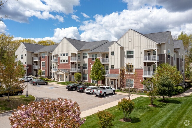
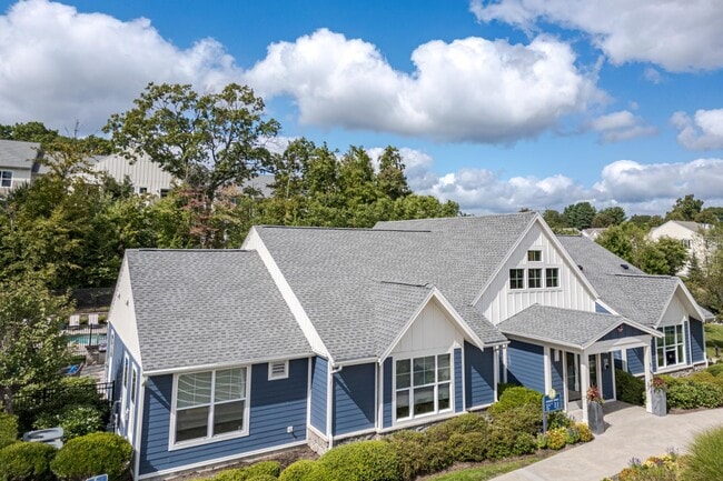
Property Record
1 Woodview Way, Hopkinton, MA 01748
NEARBY LISTINGS FOR SALE OR LEASE
Property Detail
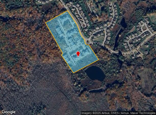
1 Woodview Way
HOPK-000013U-000001-C000000
Middlesex
Apartment
Massachusetts
A
c
25017C0610G
18.22 AC
2025
495-South
2025
Boston
320107
Boston-Cambridge-Newton, MA-NH
DEMOGRAPHICS near 1 Woodview Way
1 Mile
3 Mile
5 Mile
2024 Total Population
4,003
27,838
77,972
2029 Population
4,081
27,792
77,690
Pop Growth 2024-2029
+ 1.95%
(0.17%)
(0.36%)
Average Age
37
40
41
2024 Total Households
1,434
9,968
29,003
HH Growth 2024-2029
+ 2.02%
(0.23%)
(0.37%)
Median Household Inc
$185,690
$160,645
$134,688
Avg Household Size
2.80
2.70
2.60
2024 Avg HH Vehicles
2.00
2.00
2.00
Median Home Value
$739,195
$690,159
$609,838
Median Year Built
2010
1990
1979
Nearby Places
Map Layers
Map Styles
 Street
 Aerial
- Restaurants
- Banks
- Shops
- Fitness
- Groceries
PUBLIC TRANSPORTATION
COMMUTER RAIL
Ashland (Framingham/Worcester Line - Massachusetts Bay Transportation Authority Commuter Rail (Purple Line))
DRIVE
WALK
Distance
Ashland (Framingham/Worcester Line - Massachusetts Bay Transportation Authority Commuter Rail (Purple Line))
10 min
3.6 mi
Southborough (Framingham/Worcester Line - Massachusetts Bay Transportation Authority Commuter Rail (Purple Line))
DRIVE
WALK
Distance
Southborough (Framingham/Worcester Line - Massachusetts Bay Transportation Authority Commuter Rail (Purple Line))
8 min
4.6 mi
AIRPORT
Worcester Regional
DRIVE
WALK
Distance
Worcester Regional
43 min
26.1 mi
General Edward Lawrence Logan International
DRIVE
WALK
Distance
General Edward Lawrence Logan International
50 min
31.1 mi
Freight Ports
Port of Boston
DRIVE
WALK
Distance
Port of Boston
49 min
29.4 mi
Nearby Properties
Address
Land Use
TOTAL SIZE
Lot Size
Zoning
Address
Land Use
TOTAL SIZE
Lot Size
Zoning
556,849 SF
28.44 AC
R4
Address
Land Use
TOTAL SIZE
Lot Size
Zoning
35.54 AC
Address
Land Use
TOTAL SIZE
Lot Size
Zoning
51.50 AC
A2
Address
Land Use
TOTAL SIZE
Lot Size
Zoning
143,464 SF
108.03 AC
RB
Address
Land Use
TOTAL SIZE
Lot Size
Zoning
25.20 AC
A
Address
Land Use
TOTAL SIZE
Lot Size
Zoning
133,897 SF
11.17 AC
RB1
Address
Land Use
TOTAL SIZE
Lot Size
Zoning
94,399 SF
28.70 AC
RB1
Address
Land Use
TOTAL SIZE
Lot Size
Zoning
7.81 AC
BR
Address
Land Use
TOTAL SIZE
Lot Size
Zoning
90,256 SF
14.48 AC
R4
Address
Land Use
TOTAL SIZE
Lot Size
Zoning
226,884 SF
6.16 AC
WMUSD
Address
Land Use
TOTAL SIZE
Lot Size
Zoning
113,540 SF
5.89 AC
CS
Address
Land Use
TOTAL SIZE
Lot Size
Zoning
162,890 SF
15.47 AC
Address
Land Use
TOTAL SIZE
Lot Size
Zoning
71,070 SF
1.66 AC
R4
Address
Land Use
TOTAL SIZE
Lot Size
Zoning
85,380 SF
15.02 AC
R4
Address
Land Use
TOTAL SIZE
Lot Size
Zoning
134.63 AC
A
Address
Land Use
TOTAL SIZE
Lot Size
Zoning
40,000 SF
26.63 AC
30
Address
Land Use
TOTAL SIZE
Lot Size
Zoning
141,100 SF
20.53 AC
IA
Address
Land Use
TOTAL SIZE
Lot Size
Zoning
36.90 AC
RA
Address
Land Use
TOTAL SIZE
Lot Size
Zoning
48,269 SF
9.22 AC
Address
Land Use
TOTAL SIZE
Lot Size
Zoning
101,450 SF
11.46 AC
Address
Land Use
TOTAL SIZE
Lot Size
Zoning
1,100 SF
796.20 AC
A
Address
Land Use
TOTAL SIZE
Lot Size
Zoning
63,600 SF
4.93 AC
IA
Address
Land Use
TOTAL SIZE
Lot Size
Zoning
53,945 SF
11.47 AC
C
Address
Land Use
TOTAL SIZE
Lot Size
Zoning
291,513 SF
4.79 AC
30
Address
Land Use
TOTAL SIZE
Lot Size
Zoning
100,000 SF
2.86 AC
30
Address
Land Use
TOTAL SIZE
Lot Size
Zoning
68,722 SF
10.29 AC
Address
Land Use
TOTAL SIZE
Lot Size
Zoning
43,950 SF
4.02 AC
R4
Address
Land Use
TOTAL SIZE
Lot Size
Zoning
57,744 SF
10.49 AC
BD
Address
Land Use
TOTAL SIZE
Lot Size
Zoning
46,904 SF
1.42 AC
R4
The World's #1 Commercial Real Estate Marketplace
Connect with us
© 2026 CoStar Group
The information above has been obtained from sources believed reliable. While we do not doubt its accuracy we have not verified it and make no guarantee, warranty or representation about it. It is your responsibility to independently confirm its accuracy and completeness. Any projections, opinions, assumptions, or estimates used are for example only and do not represent the current or future performance of the property. The value of this transaction to you depends on tax and other factors which should be evaluated by your tax, financial, and legal advisors. You and your advisors should conduct a careful, independent investigation of the property to determine to your satisfaction the suitability of the property for your needs.