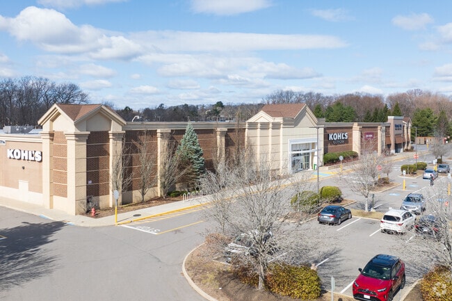
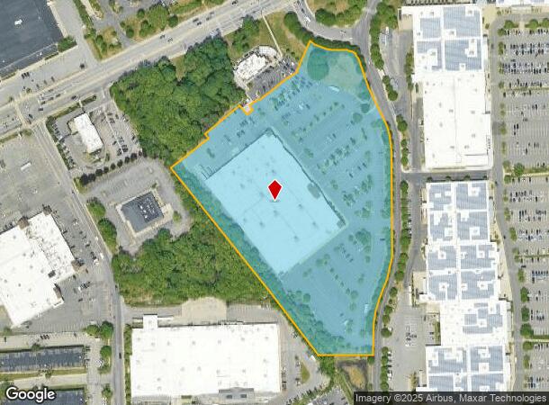
Property Record
355 Cochituate Rd, Framingham, MA 01701
NEARBY LISTINGS FOR SALE OR LEASE
Property Detail
355 Cochituate Rd
FRAM-000093-000035-005290
Middlesex
Regionalshoppingcenterormallwithanchorstore
Massachusetts
X
5290
25017C0517F
10.03 AC
2025
Framingham/Natick
2025
Boston
383903
Boston-Cambridge-Newton, MA-NH
103,620 SF
DEMOGRAPHICS near 355 Cochituate Rd
1 Mile
3 Mile
5 Mile
2024 Total Population
10,457
91,081
150,810
2029 Population
10,316
90,269
149,653
Pop Growth 2024-2029
(1.35%)
(0.89%)
(0.77%)
Average Age
41
40
41
2024 Total Households
4,262
35,003
57,542
HH Growth 2024-2029
(1.43%)
(1.00%)
(0.84%)
Median Household Inc
$96,827
$99,495
$115,344
Avg Household Size
2.40
2.50
2.50
2024 Avg HH Vehicles
2.00
2.00
2.00
Median Home Value
$593,727
$606,670
$672,911
Median Year Built
1966
1962
1966
Nearby Places
Map Layers
Map Styles
 Street
 Aerial
- Restaurants
- Banks
- Shops
- Fitness
- Groceries
PUBLIC TRANSPORTATION
COMMUTER RAIL
Framingham (Framingham/Worcester Line - Massachusetts Bay Transportation Authority Commuter Rail (Purple Line))
DRIVE
WALK
Distance
Framingham (Framingham/Worcester Line - Massachusetts Bay Transportation Authority Commuter Rail (Purple Line))
7 min
2.6 mi
DRIVE
WALK
Distance
8 min
2.7 mi
AIRPORT
General Edward Lawrence Logan International
DRIVE
WALK
Distance
General Edward Lawrence Logan International
34 min
22.8 mi
Worcester Regional
DRIVE
WALK
Distance
Worcester Regional
46 min
26.6 mi
Freight Ports
Port of Boston
DRIVE
WALK
Distance
Port of Boston
33 min
21.1 mi
SALE & LEASE HISTORY
LISTING DATE
SALE/LEASE

Jul 16, 2020
For Lease
Nearby Properties
Address
Land Use
TOTAL SIZE
Lot Size
Zoning
Address
Land Use
TOTAL SIZE
Lot Size
Zoning
246,505 SF
6.48 AC
INII
Address
Land Use
TOTAL SIZE
Lot Size
Zoning
478,440 SF
11.97 AC
B
Address
Land Use
TOTAL SIZE
Lot Size
Zoning
396,002 SF
44.44 AC
R1
Address
Land Use
TOTAL SIZE
Lot Size
Zoning
509,007 SF
22.27 AC
HM-I
Address
Land Use
TOTAL SIZE
Lot Size
Zoning
304,444 SF
16.88 AC
INII
Address
Land Use
TOTAL SIZE
Lot Size
Zoning
94,545 SF
11.70 AC
RSA
Address
Land Use
TOTAL SIZE
Lot Size
Zoning
188,746 SF
46.90 AC
RSA
Address
Land Use
TOTAL SIZE
Lot Size
Zoning
137,000 SF
18.96 AC
R1
Address
Land Use
TOTAL SIZE
Lot Size
Zoning
837,977 SF
18.57 AC
M1
Address
Land Use
TOTAL SIZE
Lot Size
Zoning
493,918 SF
28.90 AC
R1
Address
Land Use
TOTAL SIZE
Lot Size
Zoning
315,055 SF
40.38 AC
G
Address
Land Use
TOTAL SIZE
Lot Size
Zoning
20,704 SF
13.36 AC
PCD
Address
Land Use
TOTAL SIZE
Lot Size
Zoning
264,247 SF
6.09 AC
M1
Address
Land Use
TOTAL SIZE
Lot Size
Zoning
273,474 SF
7.46 AC
B
Address
Land Use
TOTAL SIZE
Lot Size
Zoning
269,426 SF
HM-II
Address
Land Use
TOTAL SIZE
Lot Size
Zoning
136,919 SF
13.42 AC
M
Address
Land Use
TOTAL SIZE
Lot Size
Zoning
165,382 SF
12.46 AC
HPU
Address
Land Use
TOTAL SIZE
Lot Size
Zoning
122,748 SF
16.90 AC
HPU
Address
Land Use
TOTAL SIZE
Lot Size
Zoning
256,830 SF
12.61 AC
B
Address
Land Use
TOTAL SIZE
Lot Size
Zoning
207,522 SF
10.11 AC
B
Address
Land Use
TOTAL SIZE
Lot Size
Zoning
79.30 AC
RSA
Address
Land Use
TOTAL SIZE
Lot Size
Zoning
198,692 SF
2.60 AC
CII
Address
Land Use
TOTAL SIZE
Lot Size
Zoning
182,524 SF
3.60 AC
B2
Address
Land Use
TOTAL SIZE
Lot Size
Zoning
244,033 SF
25.75 AC
R1
Address
Land Use
TOTAL SIZE
Lot Size
Zoning
199,320 SF
16.65 AC
RSA
Address
Land Use
TOTAL SIZE
Lot Size
Zoning
108.84 AC
M
Address
Land Use
TOTAL SIZE
Lot Size
Zoning
372,275 SF
3.05 AC
CB
Address
Land Use
TOTAL SIZE
Lot Size
Zoning
251,366 SF
14.42 AC
G
Address
Land Use
TOTAL SIZE
Lot Size
Zoning
231,897 SF
7.90 AC
B
Address
Land Use
TOTAL SIZE
Lot Size
Zoning
3.02 AC
CB
The World's #1 Commercial Real Estate Marketplace
Connect with us
© 2026 CoStar Group
The information above has been obtained from sources believed reliable. While we do not doubt its accuracy we have not verified it and make no guarantee, warranty or representation about it. It is your responsibility to independently confirm its accuracy and completeness. Any projections, opinions, assumptions, or estimates used are for example only and do not represent the current or future performance of the property. The value of this transaction to you depends on tax and other factors which should be evaluated by your tax, financial, and legal advisors. You and your advisors should conduct a careful, independent investigation of the property to determine to your satisfaction the suitability of the property for your needs.