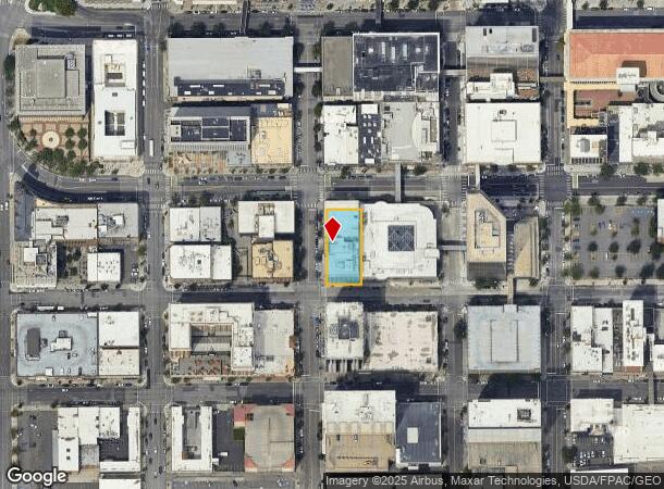
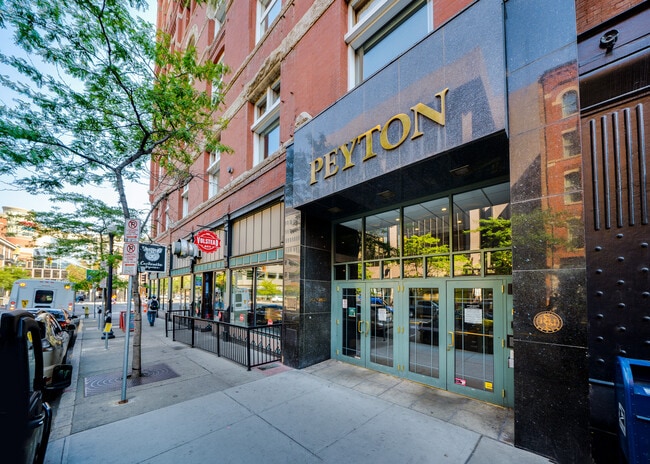
Property Record
10 N Post St, Spokane, WA 99201


NEARBY LISTINGS FOR SALE OR LEASE
Property Detail
10 N Post St
Spokane-Spokane Valley, WA
Res&Add Spokane Falls
35183.0507
RES&ADD SPOKANE FALLS W1/2 OF L4&ALL OF L5 B22
Apartment
Spokane
X
Washington
53063C0541D
4,5
2025
0.35 AC
2025
Spokane CBD
003500
Spokane
106,428 SF
DEMOGRAPHICS near 10 N Post St
1 Mile
3 Mile
5 Mile
2024 Total Population
19,058
113,978
234,303
2029 Population
20,428
121,448
249,401
Pop Growth 2024-2029
+ 7.19%
+ 6.55%
+ 6.44%
Average Age
40
39
39
2024 Total Households
9,967
49,177
98,072
HH Growth 2024-2029
+ 8.02%
+ 6.97%
+ 6.74%
Median Household Inc
$35,611
$54,637
$58,173
Avg Household Size
1.60
2.10
2.30
2024 Avg HH Vehicles
1.00
2.00
2.00
Median Home Value
$348,611
$321,566
$312,503
Median Year Built
1955
1951
1962
Nearby Places
Map Layers
Map Styles
 Street
 Aerial
- Restaurants
- Banks
- Shops
- Fitness
- Groceries
PUBLIC TRANSPORTATION
COMMUTER RAIL
DRIVE
WALK
Distance
2 min
8 min
0.4 mi
AIRPORT
Spokane International
DRIVE
WALK
Distance
Spokane International
11 min
6.1 mi
SALE & LEASE HISTORY
LISTING DATE
SALE/LEASE

Sep 25, 2016
For Lease
Oct 05, 2020
For Sale
Nov 01, 2021
For Lease
Nearby Properties
Address
Land Use
TOTAL SIZE
Lot Size
Zoning
Address
Land Use
TOTAL SIZE
Lot Size
Zoning
763,627 SF
12.44 AC
OR
Address
Land Use
TOTAL SIZE
Lot Size
Zoning
831,429 SF
119.79 AC
Address
Land Use
TOTAL SIZE
Lot Size
Zoning
481,348 SF
17.09 AC
DTU
Address
Land Use
TOTAL SIZE
Lot Size
Zoning
629,722 SF
26.28 AC
RHD
Address
Land Use
TOTAL SIZE
Lot Size
Zoning
917,113 SF
100.67 AC
LI
Address
Land Use
TOTAL SIZE
Lot Size
Zoning
157,882 SF
42.70 AC
DTG
Address
Land Use
TOTAL SIZE
Lot Size
Zoning
123,047 SF
3.95 AC
DTG
Address
Land Use
TOTAL SIZE
Lot Size
Zoning
241,106 SF
3.92 AC
CB
Address
Land Use
TOTAL SIZE
Lot Size
Zoning
536,438 SF
1.70 AC
DTC
Address
Land Use
TOTAL SIZE
Lot Size
Zoning
154,800 SF
20.06 AC
DTG
Address
Land Use
TOTAL SIZE
Lot Size
Zoning
251,542 SF
5.78 AC
DTG
Address
Land Use
TOTAL SIZE
Lot Size
Zoning
180,822 SF
16.11 AC
CC1
Address
Land Use
TOTAL SIZE
Lot Size
Zoning
139,485 SF
16.74 AC
RSF
Address
Land Use
TOTAL SIZE
Lot Size
Zoning
107,800 SF
3.20 AC
CB
Address
Land Use
TOTAL SIZE
Lot Size
Zoning
379,678 SF
20.64 AC
LI
Address
Land Use
TOTAL SIZE
Lot Size
Zoning
91,882 SF
2.07 AC
OR
Address
Land Use
TOTAL SIZE
Lot Size
Zoning
124,234 SF
13.54 AC
RSF
Address
Land Use
TOTAL SIZE
Lot Size
Zoning
314,149 SF
1.07 AC
DTC
Address
Land Use
TOTAL SIZE
Lot Size
Zoning
151,667 SF
7.45 AC
DTG
Address
Land Use
TOTAL SIZE
Lot Size
Zoning
289,705 SF
3.36 AC
OR
Address
Land Use
TOTAL SIZE
Lot Size
Zoning
112,634 SF
3.87 AC
OR
Address
Land Use
TOTAL SIZE
Lot Size
Zoning
50,869 SF
0.61 AC
DTC
Address
Land Use
TOTAL SIZE
Lot Size
Zoning
137,503 SF
17.31 AC
GC
Address
Land Use
TOTAL SIZE
Lot Size
Zoning
228,981 SF
5.32 AC
RHD
Address
Land Use
TOTAL SIZE
Lot Size
Zoning
290,380 SF
2.11 AC
CA3
Address
Land Use
TOTAL SIZE
Lot Size
Zoning
182,088 SF
0.37 AC
DTC
Address
Land Use
TOTAL SIZE
Lot Size
Zoning
107,240 SF
1.54 AC
CC1
Address
Land Use
TOTAL SIZE
Lot Size
Zoning
53,748 SF
1.26 AC
DTC
Address
Land Use
TOTAL SIZE
Lot Size
Zoning
289,573 SF
7.73 AC
RMF
Address
Land Use
TOTAL SIZE
Lot Size
Zoning
124,249 SF
15.45 AC
RHD
The World's #1 Commercial Real Estate Marketplace
Connect with us
© 2025 CoStar Group
The information above has been obtained from sources believed reliable. While we do not doubt its accuracy we have not verified it and make no guarantee, warranty or representation about it. It is your responsibility to independently confirm its accuracy and completeness. Any projections, opinions, assumptions, or estimates used are for example only and do not represent the current or future performance of the property. The value of this transaction to you depends on tax and other factors which should be evaluated by your tax, financial, and legal advisors. You and your advisors should conduct a careful, independent investigation of the property to determine to your satisfaction the suitability of the property for your needs.