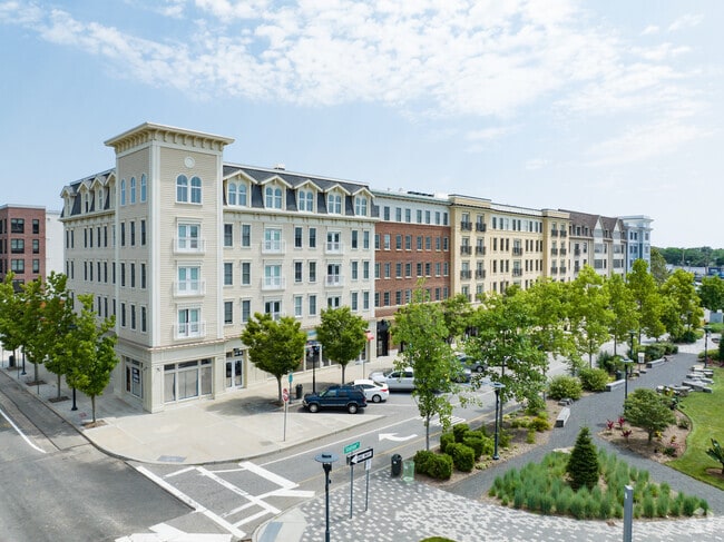
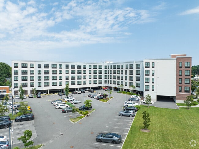
Property Record
40 Station Dr, Wyandanch, NY 11798
Current Lease Availabilities
NEARBY LISTINGS FOR SALE OR LEASE
-
-
View all Wyandanch listings for lease on LoopNet.com
Property Detail
40 Station Dr
0100-040-01-04-00-001-000
Wyandanch Village Condominium
Commercialnec
Suffolk
X
New York
36103C0640H
48
0
0.59 AC
2024
Wyandanch
122704
Long Island (New York)
103,057 SF
Nassau County-Suffolk County, NY
DEMOGRAPHICS near 40 Station Dr
1 Mile
3 Mile
5 Mile
2024 Total Population
16,674
97,602
249,730
2029 Population
16,318
95,439
244,382
Pop Growth 2024-2029
(2.14%)
(2.22%)
(2.14%)
Average Age
37
40
41
2024 Total Households
4,529
30,158
80,243
HH Growth 2024-2029
(2.25%)
(2.46%)
(2.32%)
Median Household Inc
$102,556
$117,089
$119,961
Avg Household Size
3.50
3.10
3.00
2024 Avg HH Vehicles
2.00
2.00
2.00
Median Home Value
$450,987
$463,091
$480,338
Median Year Built
1970
1964
1963
Nearby Places
Map Layers
Map Styles
 Street
 Aerial
- Restaurants
- Banks
- Shops
- Fitness
- Groceries
PUBLIC TRANSPORTATION
COMMUTER RAIL
Wyandanch Station (Ronkonkoma Branch - Long Island Rail Road)
DRIVE
WALK
Distance
Wyandanch Station (Ronkonkoma Branch - Long Island Rail Road)
1 min
5 min
0.3 mi
Pinelawn Station (Ronkonkoma Branch - Long Island Rail Road)
DRIVE
WALK
Distance
Pinelawn Station (Ronkonkoma Branch - Long Island Rail Road)
6 min
2.6 mi
AIRPORT
Long Island MacArthur
DRIVE
WALK
Distance
Long Island MacArthur
27 min
17.2 mi
John F Kennedy International
DRIVE
WALK
Distance
John F Kennedy International
41 min
28.9 mi
LaGuardia
DRIVE
WALK
Distance
LaGuardia
51 min
31.9 mi
Freight Ports
NY - Red Hook Container Terminal
DRIVE
WALK
Distance
NY - Red Hook Container Terminal
62 min
40.3 mi
Nearby Properties
Address
Land Use
TOTAL SIZE
Lot Size
Zoning
Address
Land Use
TOTAL SIZE
Lot Size
Zoning
777,483 SF
80.70 AC
GA
Address
Land Use
TOTAL SIZE
Lot Size
Zoning
756 SF
0.36 AC
B1
Address
Land Use
TOTAL SIZE
Lot Size
Zoning
3.31 AC
R40
Address
Land Use
TOTAL SIZE
Lot Size
Zoning
2,388 SF
0.36 AC
B1
Address
Land Use
TOTAL SIZE
Lot Size
Zoning
400 AC
A
Address
Land Use
TOTAL SIZE
Lot Size
Zoning
24.75 AC
R40
Address
Land Use
TOTAL SIZE
Lot Size
Zoning
1,680 SF
0.15 AC
B1
Address
Land Use
TOTAL SIZE
Lot Size
Zoning
5.95 AC
C
Address
Land Use
TOTAL SIZE
Lot Size
Zoning
0.55 AC
VILLA
Address
Land Use
TOTAL SIZE
Lot Size
Zoning
16.90 AC
EA
Address
Land Use
TOTAL SIZE
Lot Size
Zoning
11.10 AC
SC
Address
Land Use
TOTAL SIZE
Lot Size
Zoning
114.70 AC
A
Address
Land Use
TOTAL SIZE
Lot Size
Zoning
292.40 AC
A
Address
Land Use
TOTAL SIZE
Lot Size
Zoning
0.26 AC
R20
Address
Land Use
TOTAL SIZE
Lot Size
Zoning
32.60 AC
I1
Address
Land Use
TOTAL SIZE
Lot Size
Zoning
52.20 AC
R40
Address
Land Use
TOTAL SIZE
Lot Size
Zoning
16.81 AC
Address
Land Use
TOTAL SIZE
Lot Size
Zoning
248.60 AC
A
Address
Land Use
TOTAL SIZE
Lot Size
Zoning
200,065 SF
16.60 AC
GA
Address
Land Use
TOTAL SIZE
Lot Size
Zoning
33 AC
R40
Address
Land Use
TOTAL SIZE
Lot Size
Zoning
260,092 SF
7.07 AC
GA
Address
Land Use
TOTAL SIZE
Lot Size
Zoning
15.20 AC
Address
Land Use
TOTAL SIZE
Lot Size
Zoning
232.90 AC
A
Address
Land Use
TOTAL SIZE
Lot Size
Zoning
12.35 AC
R40
Address
Land Use
TOTAL SIZE
Lot Size
Zoning
10.10 AC
SC
Address
Land Use
TOTAL SIZE
Lot Size
Zoning
14.23 AC
I1
Address
Land Use
TOTAL SIZE
Lot Size
Zoning
Address
Land Use
TOTAL SIZE
Lot Size
Zoning
140.60 AC
R40
Address
Land Use
TOTAL SIZE
Lot Size
Zoning
94,566 SF
9.90 AC
E
Address
Land Use
TOTAL SIZE
Lot Size
Zoning
11.13 AC
R40
The World's #1 Commercial Real Estate Marketplace
Connect with us
© 2025 CoStar Group
The information above has been obtained from sources believed reliable. While we do not doubt its accuracy we have not verified it and make no guarantee, warranty or representation about it. It is your responsibility to independently confirm its accuracy and completeness. Any projections, opinions, assumptions, or estimates used are for example only and do not represent the current or future performance of the property. The value of this transaction to you depends on tax and other factors which should be evaluated by your tax, financial, and legal advisors. You and your advisors should conduct a careful, independent investigation of the property to determine to your satisfaction the suitability of the property for your needs.