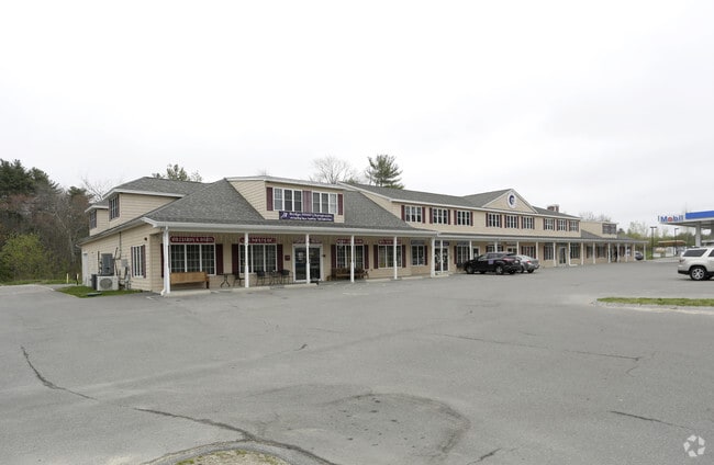
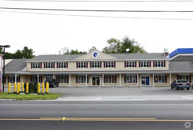
Property Record
10 Bridge St, Pelham, NH 03076

Property Detail
10 Bridge St
Regionalshoppingcenterormallwithanchorstore
Hillsborough
I
New Hampshire
AE The base floodplain where base flood elevations are provided. AE Zones are now used on new format FIRMs instead of A1-A30 Zones.
3.15 AC
2025
Hillsborough
2025
Boston
200300
Manchester-Nashua, NH
17,456 SF
PLHM-000041-000000-000010-000246
NEARBY LISTINGS FOR SALE OR LEASE
DEMOGRAPHICS near 10 Bridge St
1 mile
3 mile
5 mile
2025 Total Population
1,666
41,692
162,097
2030 Population
1,727
43,009
166,693
Pop Growth 2025-2030
+ 3.66%
+ 3.16%
+ 2.84%
Average Age
43
41
40
2025 Total Households
580
15,130
57,993
HH Growth 2025-2030
+ 3.62%
+ 3.25%
+ 2.98%
Median Household Inc
$126,059
$104,210
$94,057
Avg Household Size
2.80
2.70
2.60
2025 Avg HH Vehicles
2.00
2.00
2.00
Median Home Value
$536,245
$478,792
$493,185
Median Year Built
1977
1972
1965
Nearby Places
Map Layers
Map Styles
 Street
 Aerial
Layers
 Traffic
 Biking
Places
Listings with unknown addresses are not visible on the map
- Restaurants
- Banks
- Shops
- Fitness
- Groceries
PUBLIC TRANSPORTATION
COMMUTER RAIL
Lowell (Lowell Line - Massachusetts Bay Transportation Authority Commuter Rail (Purple Line))
Drive
Walk
Distance
Lowell (Lowell Line - Massachusetts Bay Transportation Authority Commuter Rail (Purple Line))
11 min
5.0 mi
North Billerica (Lowell Line - Massachusetts Bay Transportation Authority Commuter Rail (Purple Line))
Drive
Walk
Distance
North Billerica (Lowell Line - Massachusetts Bay Transportation Authority Commuter Rail (Purple Line))
19 min
8.5 mi
AIRPORT
Manchester Boston Regional
Drive
Walk
Distance
Manchester Boston Regional
45 min
26.6 mi
General Edward Lawrence Logan International
Drive
Walk
Distance
General Edward Lawrence Logan International
51 min
34.9 mi
Portsmouth International at Pease
Drive
Walk
Distance
Portsmouth International at Pease
67 min
47.4 mi
Freight Ports
Port of Boston
Drive
Walk
Distance
Port of Boston
52 min
34.6 mi
Nearby Properties
Address
Land Use
TOTAL SIZE
Lot Size
Zoning
Address
Land Use
TOTAL SIZE
Lot Size
Zoning
70.20 AC
R3
Address
Land Use
TOTAL SIZE
Lot Size
Zoning
803 SF
3.29 AC
R1
Address
Land Use
TOTAL SIZE
Lot Size
Zoning
20.88 AC
TSF
Address
Land Use
TOTAL SIZE
Lot Size
Zoning
Address
Land Use
TOTAL SIZE
Lot Size
Zoning
50 AC
R
Address
Land Use
TOTAL SIZE
Lot Size
Zoning
73,034 SF
2.30 AC
TMF
Address
Land Use
TOTAL SIZE
Lot Size
Zoning
2.15 AC
R
Address
Land Use
TOTAL SIZE
Lot Size
Zoning
76 AC
R
Address
Land Use
TOTAL SIZE
Lot Size
Zoning
8 AC
R3
Address
Land Use
TOTAL SIZE
Lot Size
Zoning
8.45 AC
RR
Address
Land Use
TOTAL SIZE
Lot Size
Zoning
12.21 AC
B
Address
Land Use
TOTAL SIZE
Lot Size
Zoning
171,166 SF
11 AC
I
Address
Land Use
TOTAL SIZE
Lot Size
Zoning
69,310 SF
6.79 AC
I1
Address
Land Use
TOTAL SIZE
Lot Size
Zoning
3.38 AC
R3
Address
Land Use
TOTAL SIZE
Lot Size
Zoning
8.76 AC
I
Address
Land Use
TOTAL SIZE
Lot Size
Zoning
63,138 SF
0.68 AC
I1
Address
Land Use
TOTAL SIZE
Lot Size
Zoning
11,434 SF
4.81 AC
R3
Address
Land Use
TOTAL SIZE
Lot Size
Zoning
4.33 AC
B3
Address
Land Use
TOTAL SIZE
Lot Size
Zoning
2.54 AC
TMF
Address
Land Use
TOTAL SIZE
Lot Size
Zoning
1.16 AC
SMF
Address
Land Use
TOTAL SIZE
Lot Size
Zoning
2,904 SF
15 AC
R3
Address
Land Use
TOTAL SIZE
Lot Size
Zoning
41,628 SF
1 AC
TMF
Address
Land Use
TOTAL SIZE
Lot Size
Zoning
80,140 SF
2.30 AC
B3
Address
Land Use
TOTAL SIZE
Lot Size
Zoning
27,204 SF
2.62 AC
B3
Address
Land Use
TOTAL SIZE
Lot Size
Zoning
24,508 SF
0.95 AC
R3
Address
Land Use
TOTAL SIZE
Lot Size
Zoning
70,047 SF
3.38 AC
B3
Address
Land Use
TOTAL SIZE
Lot Size
Zoning
19 AC
MUZD
Address
Land Use
TOTAL SIZE
Lot Size
Zoning
Address
Land Use
TOTAL SIZE
Lot Size
Zoning
42,659 SF
23 AC
R
Address
Land Use
TOTAL SIZE
Lot Size
Zoning
86,561 SF
2.40 AC
B4
The World's #1 Commercial Real Estate Marketplace
Connect with us
© 2026 CoStar Group
The information above has been obtained from sources believed reliable. While we do not doubt its accuracy we have not verified it and make no guarantee, warranty or representation about it. It is your responsibility to independently confirm its accuracy and completeness. Any projections, opinions, assumptions, or estimates used are for example only and do not represent the current or future performance of the property. The value of this transaction to you depends on tax and other factors which should be evaluated by your tax, financial, and legal advisors. You and your advisors should conduct a careful, independent investigation of the property to determine to your satisfaction the suitability of the property for your needs.