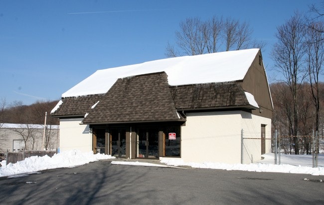
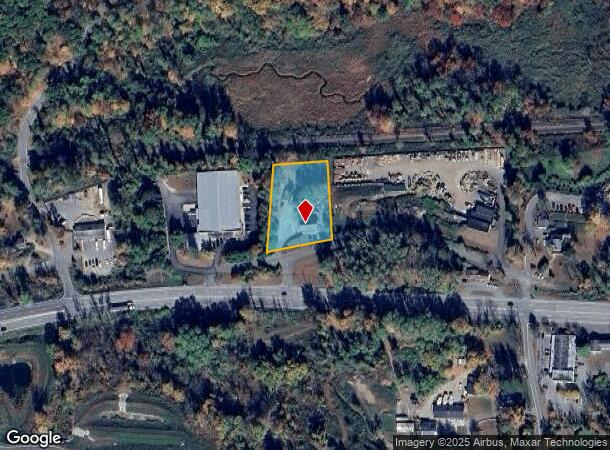
Property Record
10 Brush Hollow Rd, Brewster, NY 10509
NEARBY LISTINGS FOR SALE OR LEASE
Property Detail
10 Brush Hollow Rd
373089-068-000-0002-045-000-0000
Putnam
Commercialnec
New York
X
45.00
36079C0168E
1 AC
2024
Brewster
2024
Westchester/So Connecticut
011900
Dutchess County-Putnam County, NY
3,136 SF
DEMOGRAPHICS near 10 Brush Hollow Rd
1 Mile
3 Mile
5 Mile
2024 Total Population
443
15,163
48,780
2029 Population
447
15,169
48,638
Pop Growth 2024-2029
+ 0.90%
+ 0.04%
(0.29%)
Average Age
43
43
42
2024 Total Households
158
6,108
17,747
HH Growth 2024-2029
+ 0.63%
+ 0.03%
(0.34%)
Median Household Inc
$127,344
$110,121
$110,056
Avg Household Size
2.70
2.40
2.60
2024 Avg HH Vehicles
3.00
2.00
2.00
Median Home Value
$448,809
$435,164
$427,004
Median Year Built
1969
1982
1974
Nearby Places
- Restaurants
- Banks
- Shops
- Fitness
- Groceries
PUBLIC TRANSPORTATION
COMMUTER RAIL
Brewster Station (Harlem Line - Metro-North Commuter Railroad Company (Metro-North))
DRIVE
WALK
Distance
Brewster Station (Harlem Line - Metro-North Commuter Railroad Company (Metro-North))
5 min
3.6 mi
Southeast Station (Harlem Line - Metro-North Commuter Railroad Company (Metro-North))
DRIVE
WALK
Distance
Southeast Station (Harlem Line - Metro-North Commuter Railroad Company (Metro-North))
16 min
7.4 mi
AIRPORT
Westchester County
DRIVE
WALK
Distance
Westchester County
36 min
28.1 mi
New York Stewart International
DRIVE
WALK
Distance
New York Stewart International
53 min
39.2 mi
Freight Ports
Port of New Haven
DRIVE
WALK
Distance
Port of New Haven
63 min
42.9 mi
Nearby Properties
Address
Land Use
TOTAL SIZE
Lot Size
Zoning
Address
Land Use
TOTAL SIZE
Lot Size
Zoning
23,091 SF
84.73 AC
R160
Address
Land Use
TOTAL SIZE
Lot Size
Zoning
1,078.50 AC
SR 6
Address
Land Use
TOTAL SIZE
Lot Size
Zoning
505.03 AC
PND
Address
Land Use
TOTAL SIZE
Lot Size
Zoning
670.72 AC
SP Z
Address
Land Use
TOTAL SIZE
Lot Size
Zoning
253,696 SF
83.75 AC
CDD
Address
Land Use
TOTAL SIZE
Lot Size
Zoning
56.59 AC
IL40
Address
Land Use
TOTAL SIZE
Lot Size
Zoning
47.39 AC
PND
Address
Land Use
TOTAL SIZE
Lot Size
Zoning
32.98 AC
PND
Address
Land Use
TOTAL SIZE
Lot Size
Zoning
31 AC
RMF4
Address
Land Use
TOTAL SIZE
Lot Size
Zoning
146,484 SF
23.06 AC
SR 22
Address
Land Use
TOTAL SIZE
Lot Size
Zoning
196,544 SF
PND
Address
Land Use
TOTAL SIZE
Lot Size
Zoning
196,513 SF
PND
Address
Land Use
TOTAL SIZE
Lot Size
Zoning
10.44 AC
CA80
Address
Land Use
TOTAL SIZE
Lot Size
Zoning
13.39 AC
RMF-6
Address
Land Use
TOTAL SIZE
Lot Size
Zoning
67.30 AC
Address
Land Use
TOTAL SIZE
Lot Size
Zoning
Address
Land Use
TOTAL SIZE
Lot Size
Zoning
136,073 SF
PND
Address
Land Use
TOTAL SIZE
Lot Size
Zoning
135,929 SF
PND
Address
Land Use
TOTAL SIZE
Lot Size
Zoning
134,407 SF
PND
Address
Land Use
TOTAL SIZE
Lot Size
Zoning
134,436 SF
99.53 AC
PND
Address
Land Use
TOTAL SIZE
Lot Size
Zoning
201,776 SF
34 AC
IL40
Address
Land Use
TOTAL SIZE
Lot Size
Zoning
3.98 AC
IL40
Address
Land Use
TOTAL SIZE
Lot Size
Zoning
22,338 SF
2.37 AC
C
Address
Land Use
TOTAL SIZE
Lot Size
Zoning
59,257 SF
21 AC
SR 6
Address
Land Use
TOTAL SIZE
Lot Size
Zoning
2 AC
CA-80
Address
Land Use
TOTAL SIZE
Lot Size
Zoning
3,060 SF
2.47 AC
R40
Address
Land Use
TOTAL SIZE
Lot Size
Zoning
1.16 AC
SR 6
Address
Land Use
TOTAL SIZE
Lot Size
Zoning
29,847 SF
5.86 AC
PND
Address
Land Use
TOTAL SIZE
Lot Size
Zoning
2,168 SF
51.21 AC
RAAA
Address
Land Use
TOTAL SIZE
Lot Size
Zoning
66,037 SF
1.61 AC
R
The World's #1 Commercial Real Estate Marketplace
Connect with us
© 2025 CoStar Group
The information above has been obtained from sources believed reliable. While we do not doubt its accuracy we have not verified it and make no guarantee, warranty or representation about it. It is your responsibility to independently confirm its accuracy and completeness. Any projections, opinions, assumptions, or estimates used are for example only and do not represent the current or future performance of the property. The value of this transaction to you depends on tax and other factors which should be evaluated by your tax, financial, and legal advisors. You and your advisors should conduct a careful, independent investigation of the property to determine to your satisfaction the suitability of the property for your needs.