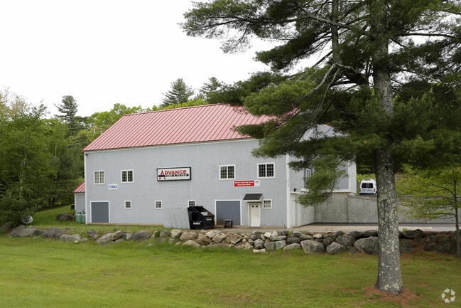
Property Record
10 Calef Hwy, Lee, NH 03861
NEARBY LISTINGS FOR SALE OR LEASE
-
-
View all Lee listings for lease on LoopNet.com
Property Detail
10 Calef Hwy
LLEE-000004-000001-000100
Strafford
Commercialbuilding
New Hampshire
X
100
33015C0120E
4.10 AC
2024
Strafford County
2024
Boston
080500
Boston-Cambridge-Newton, MA-NH
6,835 SF
DEMOGRAPHICS near 10 Calef Hwy
1 Mile
3 Mile
5 Mile
2024 Total Population
1,066
9,834
27,547
2029 Population
1,110
10,218
28,707
Pop Growth 2024-2029
+ 4.13%
+ 3.90%
+ 4.21%
Average Age
40
35
36
2024 Total Households
414
2,799
8,115
HH Growth 2024-2029
+ 4.11%
+ 4.82%
+ 5.04%
Median Household Inc
$80,529
$97,754
$111,699
Avg Household Size
2.60
2.60
2.60
2024 Avg HH Vehicles
2.00
2.00
2.00
Median Home Value
$364,893
$383,671
$400,203
Median Year Built
1980
1980
1982
Nearby Places
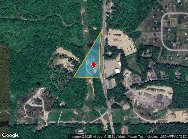
Map Layers
Map Styles
 Street
 Aerial
- Restaurants
- Banks
- Shops
- Fitness
- Groceries
PUBLIC TRANSPORTATION
COMMUTER RAIL
Durham (Downeaster - Amtrak)
DRIVE
WALK
Distance
Durham (Downeaster - Amtrak)
9 min
4.9 mi
Dover (Downeaster - Amtrak)
DRIVE
WALK
Distance
Dover (Downeaster - Amtrak)
19 min
9.8 mi
AIRPORT
Portsmouth International at Pease
DRIVE
WALK
Distance
Portsmouth International at Pease
26 min
14.7 mi
Manchester Boston Regional
DRIVE
WALK
Distance
Manchester Boston Regional
55 min
36.9 mi
Freight Ports
Portland, ME
DRIVE
WALK
Distance
Portland, ME
84 min
67.0 mi
SALE & LEASE HISTORY
LISTING DATE
SALE/LEASE

Sep 25, 2016
For Lease
Nearby Properties
Address
Land Use
TOTAL SIZE
Lot Size
Zoning
Address
Land Use
TOTAL SIZE
Lot Size
Zoning
45.41 AC
ORLI
Address
Land Use
TOTAL SIZE
Lot Size
Zoning
17.01 AC
ORLI
Address
Land Use
TOTAL SIZE
Lot Size
Zoning
440,697 SF
142.77 AC
ORLI
Address
Land Use
TOTAL SIZE
Lot Size
Zoning
9,729 SF
78.94 AC
COMM
Address
Land Use
TOTAL SIZE
Lot Size
Zoning
45,432 SF
30.15 AC
COMM
Address
Land Use
TOTAL SIZE
Lot Size
Zoning
39,372 SF
12.50 AC
ORLI
Address
Land Use
TOTAL SIZE
Lot Size
Zoning
50,875 SF
10.50 AC
RES
Address
Land Use
TOTAL SIZE
Lot Size
Zoning
9,120 SF
10.05 AC
COMM
Address
Land Use
TOTAL SIZE
Lot Size
Zoning
150,000 SF
COMM
Address
Land Use
TOTAL SIZE
Lot Size
Zoning
7.27 AC
COMM
Address
Land Use
TOTAL SIZE
Lot Size
Zoning
17.87 AC
RES
Address
Land Use
TOTAL SIZE
Lot Size
Zoning
3,016 SF
32.49 AC
COMM
Address
Land Use
TOTAL SIZE
Lot Size
Zoning
34.25 AC
RES
Address
Land Use
TOTAL SIZE
Lot Size
Zoning
13,204 SF
4.42 AC
COMM
Address
Land Use
TOTAL SIZE
Lot Size
Zoning
47 AC
COMMER
Address
Land Use
TOTAL SIZE
Lot Size
Zoning
17,103 SF
77 AC
RES
Address
Land Use
TOTAL SIZE
Lot Size
Zoning
100,000 SF
COMM
Address
Land Use
TOTAL SIZE
Lot Size
Zoning
5,027 SF
19.36 AC
RES
Address
Land Use
TOTAL SIZE
Lot Size
Zoning
41,418 SF
4.36 AC
COMMER
Address
Land Use
TOTAL SIZE
Lot Size
Zoning
48 AC
COMM 3
Address
Land Use
TOTAL SIZE
Lot Size
Zoning
11,260 SF
6.70 AC
COMMER
Address
Land Use
TOTAL SIZE
Lot Size
Zoning
8,341 SF
14.80 AC
COMM 3
Address
Land Use
TOTAL SIZE
Lot Size
Zoning
3,141 SF
15 AC
COMMER
Address
Land Use
TOTAL SIZE
Lot Size
Zoning
480 SF
25 AC
SWAIN'
Address
Land Use
TOTAL SIZE
Lot Size
Zoning
1,764 SF
189 AC
MCDANI
Address
Land Use
TOTAL SIZE
Lot Size
Zoning
4,387 SF
18.85 AC
COMM 3
Address
Land Use
TOTAL SIZE
Lot Size
Zoning
18,189 SF
8.29 AC
COMMER
Address
Land Use
TOTAL SIZE
Lot Size
Zoning
2,891 SF
6.10 AC
RES
Address
Land Use
TOTAL SIZE
Lot Size
Zoning
120 AC
COMMER
Address
Land Use
TOTAL SIZE
Lot Size
Zoning
5,834 SF
0.83 AC
COMM 3
The World's #1 Commercial Real Estate Marketplace
Connect with us
© 2025 CoStar Group
The information above has been obtained from sources believed reliable. While we do not doubt its accuracy we have not verified it and make no guarantee, warranty or representation about it. It is your responsibility to independently confirm its accuracy and completeness. Any projections, opinions, assumptions, or estimates used are for example only and do not represent the current or future performance of the property. The value of this transaction to you depends on tax and other factors which should be evaluated by your tax, financial, and legal advisors. You and your advisors should conduct a careful, independent investigation of the property to determine to your satisfaction the suitability of the property for your needs.