Property Record
10 Cedar Rd, Mickleton, NJ 08056
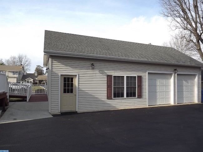

Property Detail
10 Cedar Rd
03-00904-0000-00006
Gloucester
Officebuilding
New Jersey
C
6
B and X Area of moderate flood hazard, usually the area between the limits of the 100-year and 500-year floods.
0.60 AC
2024
Gloucester County
2025
Philadelphia
500601
Philadelphia-Camden-Wilmington, PA-NJ-DE-MD
2,652 SF
NEARBY LISTINGS FOR SALE OR LEASE
-
-
View all Mickleton listings for lease on LoopNet.com
DEMOGRAPHICS near 10 Cedar Rd
1 mile
3 mile
5 mile
2025 Total Population
2,883
24,459
75,285
2030 Population
3,011
25,097
77,280
Pop Growth 2025-2030
+ 4.44%
+ 2.61%
+ 2.65%
Average Age
45
40
41
2025 Total Households
1,069
8,827
28,191
HH Growth 2025-2030
+ 4.86%
+ 2.73%
+ 2.71%
Median Household Inc
$144,401
$115,595
$107,504
Avg Household Size
2.60
2.70
2.60
2025 Avg HH Vehicles
2.00
2.00
2.00
Median Home Value
$377,209
$382,192
$351,107
Median Year Built
1994
1985
1978
Nearby Places
Map Layers
Map Styles
 Street
 Aerial
Transit
 Traffic
 Biking
Places
Listings with unknown addresses are not visible on the map
- Restaurants
- Banks
- Shops
- Fitness
- Groceries
PUBLIC TRANSPORTATION
AIRPORT
Philadelphia International
Drive
Walk
Distance
Philadelphia International
30 min
19.1 mi
Freight Ports
Broadway Terminal - Pier 5
Drive
Walk
Distance
Broadway Terminal - Pier 5
19 min
12.4 mi
SALE & LEASE HISTORY
LISTING DATE
SALE/LEASE

May 03, 2018
For Lease
Nearby Properties
Address
Land Use
TOTAL SIZE
Lot Size
Zoning
Address
Land Use
TOTAL SIZE
Lot Size
Zoning
69.05 AC
M2
Address
Land Use
TOTAL SIZE
Lot Size
Zoning
Address
Land Use
TOTAL SIZE
Lot Size
Zoning
40.25 AC
M
Address
Land Use
TOTAL SIZE
Lot Size
Zoning
32.88 AC
M1
Address
Land Use
TOTAL SIZE
Lot Size
Zoning
Address
Land Use
TOTAL SIZE
Lot Size
Zoning
Address
Land Use
TOTAL SIZE
Lot Size
Zoning
Address
Land Use
TOTAL SIZE
Lot Size
Zoning
24.27 AC
M2
Address
Land Use
TOTAL SIZE
Lot Size
Zoning
55.38 AC
M2
Address
Land Use
TOTAL SIZE
Lot Size
Zoning
111.40 AC
RRC
Address
Land Use
TOTAL SIZE
Lot Size
Zoning
31 AC
M1
Address
Land Use
TOTAL SIZE
Lot Size
Zoning
27.18 AC
M1
Address
Land Use
TOTAL SIZE
Lot Size
Zoning
30.76 AC
BP
Address
Land Use
TOTAL SIZE
Lot Size
Zoning
10.13 AC
Address
Land Use
TOTAL SIZE
Lot Size
Zoning
12.73 AC
Address
Land Use
TOTAL SIZE
Lot Size
Zoning
10.39 AC
RRC
Address
Land Use
TOTAL SIZE
Lot Size
Zoning
17.42 AC
M2
Address
Land Use
TOTAL SIZE
Lot Size
Zoning
10.21 AC
RRC
Address
Land Use
TOTAL SIZE
Lot Size
Zoning
15.08 AC
R2A
Address
Land Use
TOTAL SIZE
Lot Size
Zoning
17.08 AC
BP
Address
Land Use
TOTAL SIZE
Lot Size
Zoning
18.47 AC
M1
Address
Land Use
TOTAL SIZE
Lot Size
Zoning
7.25 AC
Address
Land Use
TOTAL SIZE
Lot Size
Zoning
22.05 AC
B1
Address
Land Use
TOTAL SIZE
Lot Size
Zoning
9.05 AC
R2
Address
Land Use
TOTAL SIZE
Lot Size
Zoning
31.77 AC
R2A
Address
Land Use
TOTAL SIZE
Lot Size
Zoning
4.19 AC
R2A
Address
Land Use
TOTAL SIZE
Lot Size
Zoning
Address
Land Use
TOTAL SIZE
Lot Size
Zoning
33.01 AC
M2
Address
Land Use
TOTAL SIZE
Lot Size
Zoning
Address
Land Use
TOTAL SIZE
Lot Size
Zoning
4.38 AC
CC
The World's #1 Commercial Real Estate Marketplace
Connect with us
© 2026 CoStar Group
The information above has been obtained from sources believed reliable. While we do not doubt its accuracy we have not verified it and make no guarantee, warranty or representation about it. It is your responsibility to independently confirm its accuracy and completeness. Any projections, opinions, assumptions, or estimates used are for example only and do not represent the current or future performance of the property. The value of this transaction to you depends on tax and other factors which should be evaluated by your tax, financial, and legal advisors. You and your advisors should conduct a careful, independent investigation of the property to determine to your satisfaction the suitability of the property for your needs.