Property Record
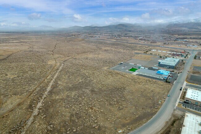
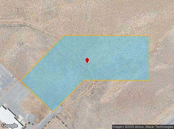
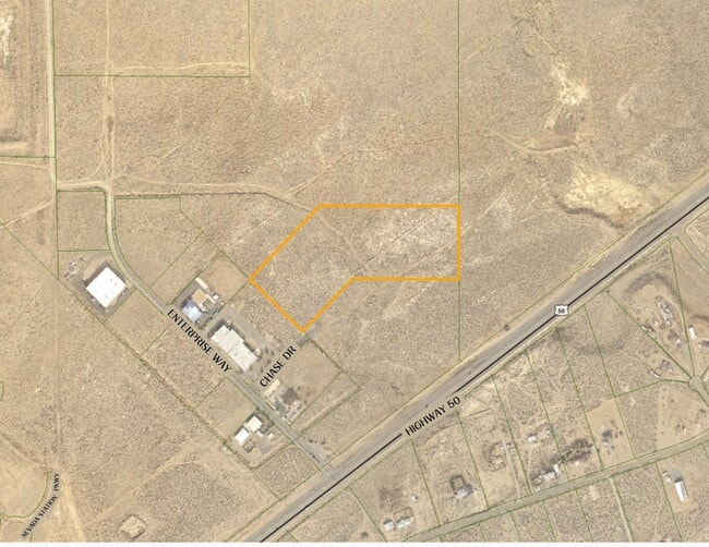
10 Chase Dr, Mark Twain, NV 89403
This Property Is For Sale
NEARBY LISTINGS FOR SALE OR LEASE
Property Detail
10 Chase Dr
Fernley, NV
APPX 250 C2 ZONE ON HIWAY PER EVAS;SEE F16
016-402-27
Lyon
Industrialacreage
Nevada
2026
15 AC
2025
Lyon County
960305
Reno/Sparks
DEMOGRAPHICS near 10 Chase Dr
1 Mile
3 Mile
5 Mile
2024 Total Population
612
15,949
18,975
2029 Population
717
18,605
22,098
Pop Growth 2024-2029
+ 17.16%
+ 16.65%
+ 16.46%
Average Age
41
44
44
2024 Total Households
222
6,210
7,399
HH Growth 2024-2029
+ 16.67%
+ 16.60%
+ 16.37%
Median Household Inc
$108,721
$93,337
$92,791
Avg Household Size
2.70
2.50
2.50
2024 Avg HH Vehicles
3.00
2.00
2.00
Median Home Value
$370,161
$428,686
$430,806
Median Year Built
2003
2000
2000
Nearby Places
Map Layers
Map Styles
 Street
 Aerial
- Restaurants
- Banks
- Shops
- Fitness
- Groceries
PUBLIC TRANSPORTATION
AIRPORT
Reno/Tahoe International
DRIVE
WALK
Distance
Reno/Tahoe International
72 min
44.7 mi
Freight Ports
Port of Stockton
DRIVE
WALK
Distance
Port of Stockton
240 min
166.4 mi
Nearby Properties
Address
Land Use
TOTAL SIZE
Lot Size
Zoning
Address
Land Use
TOTAL SIZE
Lot Size
Zoning
9,804 SF
3.31 AC
MFR
Address
Land Use
TOTAL SIZE
Lot Size
Zoning
64,532 SF
7 AC
C2
Address
Land Use
TOTAL SIZE
Lot Size
Zoning
47,941 SF
10.33 AC
MULT
Address
Land Use
TOTAL SIZE
Lot Size
Zoning
24.60 AC
MULT
Address
Land Use
TOTAL SIZE
Lot Size
Zoning
1,579 SF
6.73 AC
C2
Address
Land Use
TOTAL SIZE
Lot Size
Zoning
9,600 SF
4.50 AC
C2
Address
Land Use
TOTAL SIZE
Lot Size
Zoning
5,760 SF
3 AC
M1
Address
Land Use
TOTAL SIZE
Lot Size
Zoning
19,934 SF
2.18 AC
C2
Address
Land Use
TOTAL SIZE
Lot Size
Zoning
20,100 SF
6.58 AC
C1
Address
Land Use
TOTAL SIZE
Lot Size
Zoning
21,119 SF
3.10 AC
C2
Address
Land Use
TOTAL SIZE
Lot Size
Zoning
15,264 SF
1.60 AC
C2
Address
Land Use
TOTAL SIZE
Lot Size
Zoning
9,880 SF
2.31 AC
NR2
Address
Land Use
TOTAL SIZE
Lot Size
Zoning
35,000 SF
3 AC
M1
Address
Land Use
TOTAL SIZE
Lot Size
Zoning
3,600 SF
56.13 AC
MULT
Address
Land Use
TOTAL SIZE
Lot Size
Zoning
21,349 SF
1.82 AC
C2
Address
Land Use
TOTAL SIZE
Lot Size
Zoning
17.04 AC
C2
Address
Land Use
TOTAL SIZE
Lot Size
Zoning
672 SF
5.37 AC
C2
Address
Land Use
TOTAL SIZE
Lot Size
Zoning
42.04 AC
C2
Address
Land Use
TOTAL SIZE
Lot Size
Zoning
29,290 SF
2 AC
M1
Address
Land Use
TOTAL SIZE
Lot Size
Zoning
15,773 SF
1.80 AC
NR1
Address
Land Use
TOTAL SIZE
Lot Size
Zoning
18,456 SF
1.35 AC
C2
Address
Land Use
TOTAL SIZE
Lot Size
Zoning
37,200 SF
5.55 AC
M1
Address
Land Use
TOTAL SIZE
Lot Size
Zoning
15,543 SF
1.44 AC
C2
Address
Land Use
TOTAL SIZE
Lot Size
Zoning
4,644 SF
1.18 AC
C2
Address
Land Use
TOTAL SIZE
Lot Size
Zoning
4,537 SF
35.19 AC
RR2T
Address
Land Use
TOTAL SIZE
Lot Size
Zoning
6,940 SF
1 AC
C1
Address
Land Use
TOTAL SIZE
Lot Size
Zoning
12.39 AC
C2
Address
Land Use
TOTAL SIZE
Lot Size
Zoning
5.67 AC
C2
Address
Land Use
TOTAL SIZE
Lot Size
Zoning
7,380 SF
1.07 AC
MULT
The World's #1 Commercial Real Estate Marketplace
Connect with us
© 2025 CoStar Group
The information above has been obtained from sources believed reliable. While we do not doubt its accuracy we have not verified it and make no guarantee, warranty or representation about it. It is your responsibility to independently confirm its accuracy and completeness. Any projections, opinions, assumptions, or estimates used are for example only and do not represent the current or future performance of the property. The value of this transaction to you depends on tax and other factors which should be evaluated by your tax, financial, and legal advisors. You and your advisors should conduct a careful, independent investigation of the property to determine to your satisfaction the suitability of the property for your needs.