Property Record
10 Conte Dr, Pittsfield, MA 01201
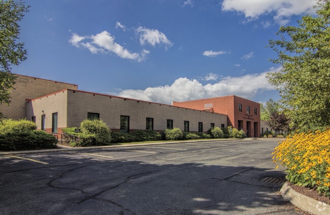

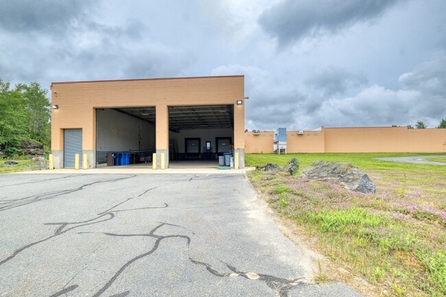
Property Detail
10 Conte Dr
PITT-000002H-000001-000102
Berkshire
Governmentalpublicusegeneral
Massachusetts
IL
102
2025
13.74 AC
2025
Massachusetts North/West Area
900800
Other Market Areas
142,802 SF
Pittsfield, MA
NEARBY LISTINGS FOR SALE OR LEASE
-
-
View all Pittsfield listings for lease on LoopNet.com
DEMOGRAPHICS near 10 Conte Dr
1 mile
3 mile
5 mile
2025 Total Population
776
23,426
44,920
2030 Population
779
22,824
43,826
Pop Growth 2025-2030
+ 0.39%
(2.57%)
(2.44%)
Average Age
48
45
45
2025 Total Households
330
10,576
20,106
HH Growth 2025-2030
+ 0.91%
(2.52%)
(2.39%)
Median Household Inc
$116,165
$67,977
$73,892
Avg Household Size
2.20
2.10
2.10
2025 Avg HH Vehicles
2.00
1.00
1.00
Median Home Value
$460,416
$286,130
$275,023
Median Year Built
1985
1948
1950
Nearby Places
Map Layers
Map Styles
 Street
 Aerial
Layers
 Traffic
 Biking
Places
Listings with unknown addresses are not visible on the map
- Restaurants
- Banks
- Shops
- Fitness
- Groceries
PUBLIC TRANSPORTATION
COMMUTER RAIL
Pittsfield Amtrak Station (Empire Service - Amtrak, Lake Shore Limited - Amtrak)
Drive
Walk
Distance
Pittsfield Amtrak Station (Empire Service - Amtrak, Lake Shore Limited - Amtrak)
9 min
3.6 mi
Freight Ports
Albany, NY Port
Drive
Walk
Distance
Albany, NY Port
65 min
43.7 mi
SALE & LEASE HISTORY
LISTING DATE
SALE/LEASE

Nov 28, 2022
For Lease
Nov 28, 2022
For Sale
Jul 12, 2021
For Lease
Nearby Properties
Address
Land Use
TOTAL SIZE
Lot Size
Zoning
Address
Land Use
TOTAL SIZE
Lot Size
Zoning
284,301 SF
8.70 AC
DCD
Address
Land Use
TOTAL SIZE
Lot Size
Zoning
34.68 AC
C-1A
Address
Land Use
TOTAL SIZE
Lot Size
Zoning
334,640 SF
2.41 AC
DCD
Address
Land Use
TOTAL SIZE
Lot Size
Zoning
21 AC
R12
Address
Land Use
TOTAL SIZE
Lot Size
Zoning
75.30 AC
R43
Address
Land Use
TOTAL SIZE
Lot Size
Zoning
1.95 AC
C-3A
Address
Land Use
TOTAL SIZE
Lot Size
Zoning
88,685 SF
10.67 AC
R20
Address
Land Use
TOTAL SIZE
Lot Size
Zoning
82,292 SF
37.50 AC
R6
Address
Land Use
TOTAL SIZE
Lot Size
Zoning
57,676 SF
6.68 AC
C-3A
Address
Land Use
TOTAL SIZE
Lot Size
Zoning
2.38 AC
DCD
Address
Land Use
TOTAL SIZE
Lot Size
Zoning
286 AC
LDI
Address
Land Use
TOTAL SIZE
Lot Size
Zoning
1.30 AC
DCD
Address
Land Use
TOTAL SIZE
Lot Size
Zoning
29,700 SF
0.56 AC
DCD
Address
Land Use
TOTAL SIZE
Lot Size
Zoning
15 AC
R20
Address
Land Use
TOTAL SIZE
Lot Size
Zoning
17.26 AC
BG
Address
Land Use
TOTAL SIZE
Lot Size
Zoning
49,209 SF
2.66 AC
RM
Address
Land Use
TOTAL SIZE
Lot Size
Zoning
34 AC
R20
Address
Land Use
TOTAL SIZE
Lot Size
Zoning
469 AC
R-3A
Address
Land Use
TOTAL SIZE
Lot Size
Zoning
106,353 SF
0.91 AC
DCD
Address
Land Use
TOTAL SIZE
Lot Size
Zoning
6.30 AC
RM
Address
Land Use
TOTAL SIZE
Lot Size
Zoning
74,460 SF
0.74 AC
DCD
Address
Land Use
TOTAL SIZE
Lot Size
Zoning
41.41 AC
R43
Address
Land Use
TOTAL SIZE
Lot Size
Zoning
57,646 SF
10.60 AC
R12
Address
Land Use
TOTAL SIZE
Lot Size
Zoning
60.30 AC
IG
Address
Land Use
TOTAL SIZE
Lot Size
Zoning
64,792 SF
2.47 AC
DCD
Address
Land Use
TOTAL SIZE
Lot Size
Zoning
1,232 SF
59.23 AC
RA-C
Address
Land Use
TOTAL SIZE
Lot Size
Zoning
79,785 SF
2.29 AC
BG
Address
Land Use
TOTAL SIZE
Lot Size
Zoning
251,070 SF
13.53 AC
IL
Address
Land Use
TOTAL SIZE
Lot Size
Zoning
1.03 AC
DCD
Address
Land Use
TOTAL SIZE
Lot Size
Zoning
44,912 SF
6.55 AC
C-1A
The World's #1 Commercial Real Estate Marketplace
Connect with us
© 2026 CoStar Group
The information above has been obtained from sources believed reliable. While we do not doubt its accuracy we have not verified it and make no guarantee, warranty or representation about it. It is your responsibility to independently confirm its accuracy and completeness. Any projections, opinions, assumptions, or estimates used are for example only and do not represent the current or future performance of the property. The value of this transaction to you depends on tax and other factors which should be evaluated by your tax, financial, and legal advisors. You and your advisors should conduct a careful, independent investigation of the property to determine to your satisfaction the suitability of the property for your needs.