Property Record
Enterprise Dr, Arundel, ME 04046

Save to a Folder
{{folder.Name}}
{{folder.ListingIds.length}} Properties
{{folder.ListingIds.length}} Property
Create a New Folder
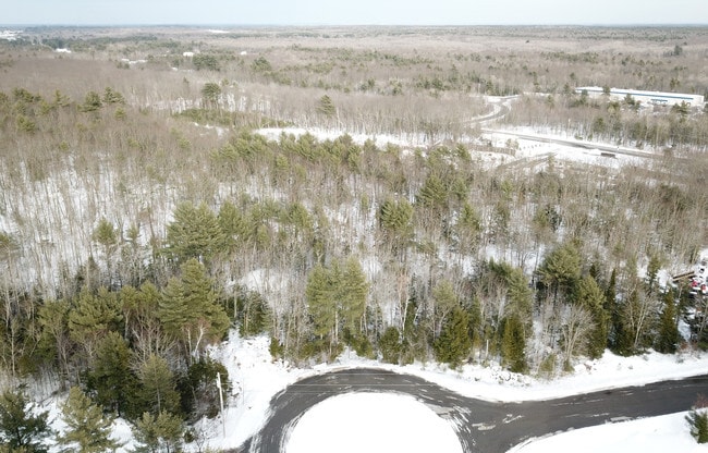
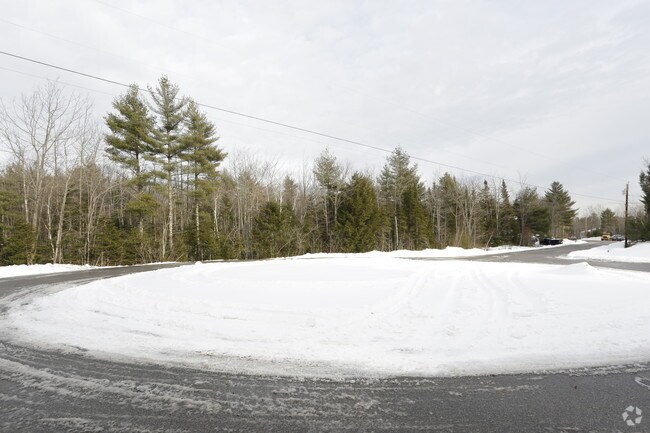
Property Detail
Enterprise Dr
ARUN-000012-000000-000008E-000010
YORK
Commercialacreage
Maine
BI
8e-10
B and X Area of moderate flood hazard, usually the area between the limits of the 100-year and 500-year floods.
1.58 AC
2025
York County
2025
Portland/South Portland
027000
Portland-South Portland, ME
NEARBY LISTINGS FOR SALE OR LEASE
DEMOGRAPHICS near Enterprise Dr
1 mile
3 mile
5 mile
2025 Total Population
870
5,475
36,119
2030 Population
905
5,656
36,852
Pop Growth 2025-2030
+ 4.02%
+ 3.31%
+ 2.03%
Average Age
44
45
44
2025 Total Households
343
2,182
15,819
HH Growth 2025-2030
+ 3.79%
+ 3.21%
+ 1.98%
Median Household Inc
$102,500
$100,038
$76,414
Avg Household Size
2.50
2.40
2.20
2025 Avg HH Vehicles
2.00
2.00
2.00
Median Home Value
$480,644
$462,708
$438,740
Median Year Built
1989
1983
1971
Nearby Places
Map Layers
Map Styles
 Street
 Aerial
Layers
 Traffic
 Biking
Places
Listings with unknown addresses are not visible on the map
- Restaurants
- Banks
- Shops
- Fitness
- Groceries
PUBLIC TRANSPORTATION
COMMUTER RAIL
Saco Amtrak Station (Downeaster - Amtrak)
Drive
Walk
Distance
Saco Amtrak Station (Downeaster - Amtrak)
10 min
5.3 mi
AIRPORT
Portland International Jetport
Drive
Walk
Distance
Portland International Jetport
28 min
19.3 mi
Portsmouth International at Pease
Drive
Walk
Distance
Portsmouth International at Pease
47 min
34.9 mi
Freight Ports
Portland, ME
Drive
Walk
Distance
Portland, ME
29 min
21.9 mi
SALE & LEASE HISTORY
LISTING DATE
SALE/LEASE

Oct 08, 2025
For Sale
Mar 03, 2017
For Sale
Nearby Properties
Address
Land Use
TOTAL SIZE
Lot Size
Zoning
Address
Land Use
TOTAL SIZE
Lot Size
Zoning
25.99 AC
M
Address
Land Use
TOTAL SIZE
Lot Size
Zoning
69,442 SF
1.12 AC
B2
Address
Land Use
TOTAL SIZE
Lot Size
Zoning
Address
Land Use
TOTAL SIZE
Lot Size
Zoning
118,458 SF
18.93 AC
B2
Address
Land Use
TOTAL SIZE
Lot Size
Zoning
136,033 SF
15.71 AC
B2
Address
Land Use
TOTAL SIZE
Lot Size
Zoning
262,580 SF
40.10 AC
I1
Address
Land Use
TOTAL SIZE
Lot Size
Zoning
197,008 SF
44.47 AC
B1
Address
Land Use
TOTAL SIZE
Lot Size
Zoning
91,642 SF
21.43 AC
R1A
Address
Land Use
TOTAL SIZE
Lot Size
Zoning
17.50 AC
B2
Address
Land Use
TOTAL SIZE
Lot Size
Zoning
119,500 SF
28.24 AC
B2
Address
Land Use
TOTAL SIZE
Lot Size
Zoning
15.36 AC
I1
Address
Land Use
TOTAL SIZE
Lot Size
Zoning
64,788 SF
25.50 AC
R1A
Address
Land Use
TOTAL SIZE
Lot Size
Zoning
77,406 SF
16 AC
R1A
Address
Land Use
TOTAL SIZE
Lot Size
Zoning
9.62 AC
B2
Address
Land Use
TOTAL SIZE
Lot Size
Zoning
39,580 SF
9.59 AC
R-2
Address
Land Use
TOTAL SIZE
Lot Size
Zoning
139,607 SF
13.20 AC
I1
Address
Land Use
TOTAL SIZE
Lot Size
Zoning
51,376 SF
7.12 AC
I3
Address
Land Use
TOTAL SIZE
Lot Size
Zoning
25.27 AC
DB-1
Address
Land Use
TOTAL SIZE
Lot Size
Zoning
20.64 AC
B2
Address
Land Use
TOTAL SIZE
Lot Size
Zoning
40,493 SF
16.65 AC
B2
Address
Land Use
TOTAL SIZE
Lot Size
Zoning
75,428 SF
7.76 AC
BI
Address
Land Use
TOTAL SIZE
Lot Size
Zoning
1,560 SF
4.75 AC
B2
Address
Land Use
TOTAL SIZE
Lot Size
Zoning
55,899 SF
8.29 AC
I3
Address
Land Use
TOTAL SIZE
Lot Size
Zoning
40,129 SF
5.18 AC
B2
Address
Land Use
TOTAL SIZE
Lot Size
Zoning
96,791 SF
4.60 AC
I1
Address
Land Use
TOTAL SIZE
Lot Size
Zoning
34,697 SF
2.58 AC
I3
Address
Land Use
TOTAL SIZE
Lot Size
Zoning
106,200 SF
15.23 AC
I1
Address
Land Use
TOTAL SIZE
Lot Size
Zoning
3,752 SF
7.66 AC
Address
Land Use
TOTAL SIZE
Lot Size
Zoning
20.38 AC
DB-1
Address
Land Use
TOTAL SIZE
Lot Size
Zoning
73,560 SF
22.10 AC
I2
The World's #1 Commercial Real Estate Marketplace
Connect with us
© 2026 CoStar Group
The information above has been obtained from sources believed reliable. While we do not doubt its accuracy we have not verified it and make no guarantee, warranty or representation about it. It is your responsibility to independently confirm its accuracy and completeness. Any projections, opinions, assumptions, or estimates used are for example only and do not represent the current or future performance of the property. The value of this transaction to you depends on tax and other factors which should be evaluated by your tax, financial, and legal advisors. You and your advisors should conduct a careful, independent investigation of the property to determine to your satisfaction the suitability of the property for your needs.