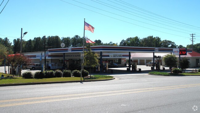
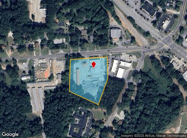
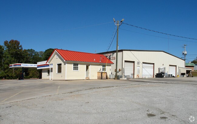
Property Record
10 Franklin Rd, Newnan, GA 30263
NEARBY LISTINGS FOR SALE OR LEASE
Property Detail
10 Franklin Rd
Atlanta-Sandy Springs-Roswell, GA
Beck Property
N41-0002-007
STORE BLDG/3.673AC HWY 34
Storebuilding
Coweta
X
Georgia
13077C0139D
a
2025
2.64 AC
2025
Coweta County
170702
Atlanta
15,946 SF
DEMOGRAPHICS near 10 Franklin Rd
1 Mile
3 Mile
5 Mile
2024 Total Population
4,892
31,271
60,374
2029 Population
5,451
34,853
67,321
Pop Growth 2024-2029
+ 11.43%
+ 11.45%
+ 11.51%
Average Age
39
38
38
2024 Total Households
1,849
11,964
23,211
HH Growth 2024-2029
+ 11.52%
+ 11.51%
+ 11.55%
Median Household Inc
$74,439
$65,183
$71,269
Avg Household Size
2.60
2.50
2.50
2024 Avg HH Vehicles
2.00
2.00
2.00
Median Home Value
$258,646
$235,260
$244,617
Median Year Built
1977
1986
1996
Nearby Places
- Restaurants
- Banks
- Shops
- Fitness
- Groceries
PUBLIC TRANSPORTATION
AIRPORT
Hartsfield - Jackson Atlanta International
DRIVE
WALK
Distance
Hartsfield - Jackson Atlanta International
46 min
34.2 mi
Freight Ports
Port of Panama City
DRIVE
WALK
Distance
Port of Panama City
315 min
256.6 mi
Nearby Properties
Address
Land Use
TOTAL SIZE
Lot Size
Zoning
Address
Land Use
TOTAL SIZE
Lot Size
Zoning
449,108 SF
53.36 AC
C2
Address
Land Use
TOTAL SIZE
Lot Size
Zoning
208,092 SF
9.85 AC
R2
Address
Land Use
TOTAL SIZE
Lot Size
Zoning
205,636 SF
32 AC
R1
Address
Land Use
TOTAL SIZE
Lot Size
Zoning
208,524 SF
19.59 AC
R2
Address
Land Use
TOTAL SIZE
Lot Size
Zoning
136,343 SF
19.77 AC
R2
Address
Land Use
TOTAL SIZE
Lot Size
Zoning
121,224 SF
15.94 AC
R2
Address
Land Use
TOTAL SIZE
Lot Size
Zoning
137,519 SF
30.65 AC
R2
Address
Land Use
TOTAL SIZE
Lot Size
Zoning
175,159 SF
20.20 AC
002
Address
Land Use
TOTAL SIZE
Lot Size
Zoning
71,484 SF
45.43 AC
R1
Address
Land Use
TOTAL SIZE
Lot Size
Zoning
118,282 SF
4.85 AC
C2
Address
Land Use
TOTAL SIZE
Lot Size
Zoning
128,510 SF
25.10 AC
R1
Address
Land Use
TOTAL SIZE
Lot Size
Zoning
124,120 SF
30.64 AC
001
Address
Land Use
TOTAL SIZE
Lot Size
Zoning
194,322 SF
14.25 AC
M
Address
Land Use
TOTAL SIZE
Lot Size
Zoning
89,435 SF
43.29 AC
R1
Address
Land Use
TOTAL SIZE
Lot Size
Zoning
131,836 SF
16.01 AC
R2
Address
Land Use
TOTAL SIZE
Lot Size
Zoning
50,956 SF
0.60 AC
C1
Address
Land Use
TOTAL SIZE
Lot Size
Zoning
68,255 SF
14.79 AC
C2
Address
Land Use
TOTAL SIZE
Lot Size
Zoning
144,349 SF
19.04 AC
C2
Address
Land Use
TOTAL SIZE
Lot Size
Zoning
112,444 SF
15.27 AC
R2
Address
Land Use
TOTAL SIZE
Lot Size
Zoning
50,536 SF
12.60 AC
R1S
Address
Land Use
TOTAL SIZE
Lot Size
Zoning
79,486 SF
6.13 AC
PS
Address
Land Use
TOTAL SIZE
Lot Size
Zoning
56,320 SF
1.33 AC
C1
Address
Land Use
TOTAL SIZE
Lot Size
Zoning
166,314 SF
15 AC
R2
Address
Land Use
TOTAL SIZE
Lot Size
Zoning
95,483 SF
16.09 AC
R1
Address
Land Use
TOTAL SIZE
Lot Size
Zoning
69,685 SF
4.93 AC
R2
Address
Land Use
TOTAL SIZE
Lot Size
Zoning
43,005 SF
854 AC
R1
Address
Land Use
TOTAL SIZE
Lot Size
Zoning
44,029 SF
78.69 AC
PS
Address
Land Use
TOTAL SIZE
Lot Size
Zoning
151,532 SF
12.25 AC
R1
Address
Land Use
TOTAL SIZE
Lot Size
Zoning
86,796 SF
22.04 AC
C
Address
Land Use
TOTAL SIZE
Lot Size
Zoning
50,722 SF
10.80 AC
R1
The World's #1 Commercial Real Estate Marketplace
Connect with us
© 2025 CoStar Group
The information above has been obtained from sources believed reliable. While we do not doubt its accuracy we have not verified it and make no guarantee, warranty or representation about it. It is your responsibility to independently confirm its accuracy and completeness. Any projections, opinions, assumptions, or estimates used are for example only and do not represent the current or future performance of the property. The value of this transaction to you depends on tax and other factors which should be evaluated by your tax, financial, and legal advisors. You and your advisors should conduct a careful, independent investigation of the property to determine to your satisfaction the suitability of the property for your needs.