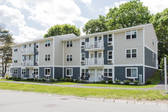
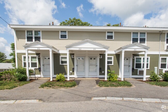
Property Record
10 Georgetowne Dr, Hyde Park, MA 02136

Property Detail
10 Georgetowne Dr
Commercialofficeresidentialmixeduse
Suffolk
RC
Massachusetts
A Areas with a 1% annual chance of flooding and a 26% chance of flooding over the life of a 30-year mortgage.
45.93 AC
0
Upper Washington-Spring St
2025
Boston
130406
Boston-Cambridge-Newton, MA-NH
26,569 SF
WROX-000000-000018-012326
NEARBY LISTINGS FOR SALE OR LEASE
DEMOGRAPHICS near 10 Georgetowne Dr
1 mile
3 mile
5 mile
2025 Total Population
16,621
140,992
341,370
2030 Population
16,887
143,598
347,906
Pop Growth 2025-2030
+ 1.60%
+ 1.85%
+ 1.91%
Average Age
41
42
41
2025 Total Households
6,528
53,768
128,104
HH Growth 2025-2030
+ 1.61%
+ 1.90%
+ 1.97%
Median Household Inc
$85,853
$115,613
$116,651
Avg Household Size
2.50
2.50
2.50
2025 Avg HH Vehicles
1.00
2.00
1.00
Median Home Value
$663,193
$715,615
$794,235
Median Year Built
1962
1950
1950
Nearby Places
Map Layers
Map Styles
 Street
 Aerial
Layers
 Traffic
 Biking
Places
Listings with unknown addresses are not visible on the map
- Restaurants
- Banks
- Shops
- Fitness
- Groceries
PUBLIC TRANSPORTATION
COMMUTER RAIL
Hyde Park (Franklin Line - Massachusetts Bay Transportation Authority Commuter Rail (Purple Line), Providence/Stoughton Line - Massachusetts Bay Transportation Authority Commuter Rail (Purple Line))
Drive
Walk
Distance
Hyde Park (Franklin Line - Massachusetts Bay Transportation Authority Commuter Rail (Purple Line), Providence/Stoughton Line - Massachusetts Bay Transportation Authority Commuter Rail (Purple Line))
6 min
2.3 mi
Fairmount (Fairmount Line - Massachusetts Bay Transportation Authority Commuter Rail (Purple Line))
Drive
Walk
Distance
Fairmount (Fairmount Line - Massachusetts Bay Transportation Authority Commuter Rail (Purple Line))
6 min
2.7 mi
AIRPORT
General Edward Lawrence Logan International
Drive
Walk
Distance
General Edward Lawrence Logan International
28 min
12.5 mi
Freight Ports
Port of Boston
Drive
Walk
Distance
Port of Boston
26 min
12.2 mi
Nearby Properties
Address
Land Use
TOTAL SIZE
Lot Size
Zoning
Address
Land Use
TOTAL SIZE
Lot Size
Zoning
317,049 SF
11.22 AC
M05
Address
Land Use
TOTAL SIZE
Lot Size
Zoning
45,000 SF
14.30 AC
E
Address
Land Use
TOTAL SIZE
Lot Size
Zoning
355,941 SF
4.60 AC
A
Address
Land Use
TOTAL SIZE
Lot Size
Zoning
413,827 SF
9.49 AC
RDO
Address
Land Use
TOTAL SIZE
Lot Size
Zoning
179.13 AC
E
Address
Land Use
TOTAL SIZE
Lot Size
Zoning
225,042 SF
63.16 AC
RA
Address
Land Use
TOTAL SIZE
Lot Size
Zoning
11.66 AC
LM
Address
Land Use
TOTAL SIZE
Lot Size
Zoning
1,660.52 AC
RA
Address
Land Use
TOTAL SIZE
Lot Size
Zoning
34.93 AC
LM
Address
Land Use
TOTAL SIZE
Lot Size
Zoning
270,991 SF
33.25 AC
RA
Address
Land Use
TOTAL SIZE
Lot Size
Zoning
21,830 SF
158.48 AC
E
Address
Land Use
TOTAL SIZE
Lot Size
Zoning
3.18 AC
M05
Address
Land Use
TOTAL SIZE
Lot Size
Zoning
332,100 SF
4.63 AC
M05
Address
Land Use
TOTAL SIZE
Lot Size
Zoning
8.18 AC
B
Address
Land Use
TOTAL SIZE
Lot Size
Zoning
22.95 AC
E
Address
Land Use
TOTAL SIZE
Lot Size
Zoning
83,891 SF
3.47 AC
RA
Address
Land Use
TOTAL SIZE
Lot Size
Zoning
475,102 SF
36.81 AC
A
Address
Land Use
TOTAL SIZE
Lot Size
Zoning
45.72 AC
LM
Address
Land Use
TOTAL SIZE
Lot Size
Zoning
7.45 AC
M05
Address
Land Use
TOTAL SIZE
Lot Size
Zoning
156,310 SF
9.40 AC
E
Address
Land Use
TOTAL SIZE
Lot Size
Zoning
100,963 SF
17.69 AC
A
Address
Land Use
TOTAL SIZE
Lot Size
Zoning
94.34 AC
E
Address
Land Use
TOTAL SIZE
Lot Size
Zoning
266,074 SF
44.50 AC
E
Address
Land Use
TOTAL SIZE
Lot Size
Zoning
35.07 AC
PUB
Address
Land Use
TOTAL SIZE
Lot Size
Zoning
148.18 AC
E
Address
Land Use
TOTAL SIZE
Lot Size
Zoning
138,986 SF
10.07 AC
E
Address
Land Use
TOTAL SIZE
Lot Size
Zoning
61,044 SF
5.60 AC
Address
Land Use
TOTAL SIZE
Lot Size
Zoning
296,340 SF
4.58 AC
A
Address
Land Use
TOTAL SIZE
Lot Size
Zoning
99,497 SF
4.12 AC
E
The World's #1 Commercial Real Estate Marketplace
Connect with us
© 2026 CoStar Group
The information above has been obtained from sources believed reliable. While we do not doubt its accuracy we have not verified it and make no guarantee, warranty or representation about it. It is your responsibility to independently confirm its accuracy and completeness. Any projections, opinions, assumptions, or estimates used are for example only and do not represent the current or future performance of the property. The value of this transaction to you depends on tax and other factors which should be evaluated by your tax, financial, and legal advisors. You and your advisors should conduct a careful, independent investigation of the property to determine to your satisfaction the suitability of the property for your needs.