Property Record
10 Hardy Rd, Westbrook, ME 04092
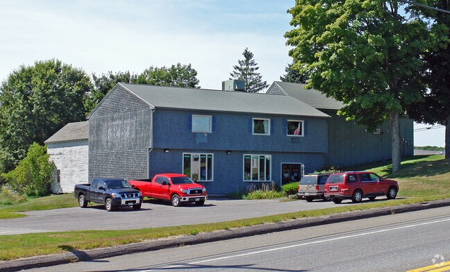

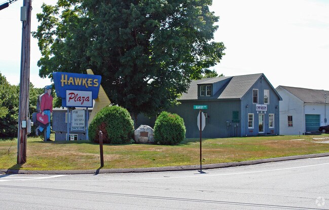
Property Detail
10 Hardy Rd
WSBR-000023-000000-000004B
Cumberland
Departmentstore
Maine
18
4-b
B and X Area of moderate flood hazard, usually the area between the limits of the 100-year and 500-year floods.
1 AC
2023
NE Cumberland County
2023
Portland/South Portland
002700
Portland-South Portland, ME
4,105 SF
NEARBY LISTINGS FOR SALE OR LEASE
DEMOGRAPHICS near 10 Hardy Rd
1 mile
3 mile
5 mile
2025 Total Population
1,035
9,068
47,113
2030 Population
1,051
9,206
47,569
Pop Growth 2025-2030
+ 1.55%
+ 1.52%
+ 0.97%
Average Age
44
43
42
2025 Total Households
430
3,590
18,932
HH Growth 2025-2030
+ 1.86%
+ 1.62%
+ 1.08%
Median Household Inc
$127,778
$126,266
$106,764
Avg Household Size
2.30
2.40
2.40
2025 Avg HH Vehicles
2.00
2.00
2.00
Median Home Value
$442,683
$463,868
$451,899
Median Year Built
1984
1984
1976
Nearby Places
Map Layers
Map Styles
 Street
 Aerial
Layers
 Traffic
 Biking
Places
Listings with unknown addresses are not visible on the map
- Restaurants
- Banks
- Shops
- Fitness
- Groceries
PUBLIC TRANSPORTATION
COMMUTER RAIL
Drive
Walk
Distance
14 min
8.5 mi
AIRPORT
Portland International Jetport
Drive
Walk
Distance
Portland International Jetport
19 min
9.0 mi
Freight Ports
Portland, ME
Drive
Walk
Distance
Portland, ME
15 min
9.0 mi
Nearby Properties
Address
Land Use
TOTAL SIZE
Lot Size
Zoning
Address
Land Use
TOTAL SIZE
Lot Size
Zoning
10.08 AC
Address
Land Use
TOTAL SIZE
Lot Size
Zoning
55.70 AC
14
Address
Land Use
TOTAL SIZE
Lot Size
Zoning
141,420 SF
11.27 AC
TIF
Address
Land Use
TOTAL SIZE
Lot Size
Zoning
56,155 SF
6.54 AC
TIF
Address
Land Use
TOTAL SIZE
Lot Size
Zoning
36.02 AC
FR/C-3
Address
Land Use
TOTAL SIZE
Lot Size
Zoning
1.79 AC
14
Address
Land Use
TOTAL SIZE
Lot Size
Zoning
27,938 SF
4.77 AC
MUC
Address
Land Use
TOTAL SIZE
Lot Size
Zoning
1,260 SF
5.77 AC
20
Address
Land Use
TOTAL SIZE
Lot Size
Zoning
7.07 AC
12
Address
Land Use
TOTAL SIZE
Lot Size
Zoning
12,097 SF
2.17 AC
WFC
Address
Land Use
TOTAL SIZE
Lot Size
Zoning
5,792 SF
13 AC
12
Address
Land Use
TOTAL SIZE
Lot Size
Zoning
7,907 SF
30.90 AC
F/SP
Address
Land Use
TOTAL SIZE
Lot Size
Zoning
14,460 SF
48.70 AC
F/SP
Address
Land Use
TOTAL SIZE
Lot Size
Zoning
25,255 SF
6.20 AC
18
Address
Land Use
TOTAL SIZE
Lot Size
Zoning
3,918 SF
1.28 AC
TIF
Address
Land Use
TOTAL SIZE
Lot Size
Zoning
2,170 SF
36.64 AC
C-3/RC
Address
Land Use
TOTAL SIZE
Lot Size
Zoning
34.68 AC
14
Address
Land Use
TOTAL SIZE
Lot Size
Zoning
240 SF
108 AC
14
Address
Land Use
TOTAL SIZE
Lot Size
Zoning
131.50 AC
12
Address
Land Use
TOTAL SIZE
Lot Size
Zoning
9,618 SF
10.50 AC
VMU
Address
Land Use
TOTAL SIZE
Lot Size
Zoning
2.08 AC
20
Address
Land Use
TOTAL SIZE
Lot Size
Zoning
3.74 AC
C-3
Address
Land Use
TOTAL SIZE
Lot Size
Zoning
9,270 SF
1.72 AC
TIF
Address
Land Use
TOTAL SIZE
Lot Size
Zoning
71.21 AC
14
Address
Land Use
TOTAL SIZE
Lot Size
Zoning
6,120 SF
1.58 AC
TIF
Address
Land Use
TOTAL SIZE
Lot Size
Zoning
4.61 AC
C-3
Address
Land Use
TOTAL SIZE
Lot Size
Zoning
8,995 SF
2.14 AC
12
Address
Land Use
TOTAL SIZE
Lot Size
Zoning
Address
Land Use
TOTAL SIZE
Lot Size
Zoning
52.22 AC
1
Address
Land Use
TOTAL SIZE
Lot Size
Zoning
640 SF
77.35 AC
20
The World's #1 Commercial Real Estate Marketplace
Connect with us
© 2026 CoStar Group
The information above has been obtained from sources believed reliable. While we do not doubt its accuracy we have not verified it and make no guarantee, warranty or representation about it. It is your responsibility to independently confirm its accuracy and completeness. Any projections, opinions, assumptions, or estimates used are for example only and do not represent the current or future performance of the property. The value of this transaction to you depends on tax and other factors which should be evaluated by your tax, financial, and legal advisors. You and your advisors should conduct a careful, independent investigation of the property to determine to your satisfaction the suitability of the property for your needs.