Property Record
10 Hudson Dr, Southwick, MA 01077

Save to a Folder
{{folder.Name}}
{{folder.ListingIds.length}} Properties
{{folder.ListingIds.length}} Property
Create a New Folder
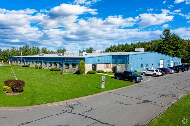
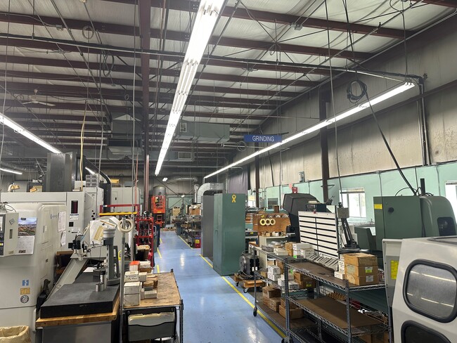
This Property Is For Sale
Property Detail
10 Hudson Dr
SWIC-000067-000000-000012
Hampden
Manufacturinglight
Massachusetts
IR
12
B and X Area of moderate flood hazard, usually the area between the limits of the 100-year and 500-year floods.
4.13 AC
2025
Hampden County
2025
Hartford
813101
Springfield, MA
41,885 SF
NEARBY LISTINGS FOR SALE OR LEASE
-
-
View all Southwick listings for sale on LoopNet.com
DEMOGRAPHICS near 10 Hudson Dr
1 mile
3 mile
5 mile
2025 Total Population
1,309
15,269
53,131
2030 Population
1,324
15,302
53,130
Pop Growth 2025-2030
+ 1.15%
+ 0.22%
0.00%
Average Age
45
45
42
2025 Total Households
549
6,167
20,814
HH Growth 2025-2030
+ 1.09%
+ 0.21%
(0.06%)
Median Household Inc
$101,856
$105,168
$91,330
Avg Household Size
2.30
2.40
2.40
2025 Avg HH Vehicles
2.00
2.00
2.00
Median Home Value
$386,817
$366,329
$348,834
Median Year Built
1977
1974
1965
Nearby Places
Map Layers
Map Styles
 Street
 Aerial
Layers
 Traffic
 Biking
Places
Listings with unknown addresses are not visible on the map
- Restaurants
- Banks
- Shops
- Fitness
- Groceries
PUBLIC TRANSPORTATION
COMMUTER RAIL
Springfield (Hartford Line - CONN DOT)
Drive
Walk
Distance
Springfield (Hartford Line - CONN DOT)
16 min
9.8 mi
AIRPORT
Bradley International
Drive
Walk
Distance
Bradley International
33 min
13.4 mi
Freight Ports
Port of New Haven
Drive
Walk
Distance
Port of New Haven
90 min
60.0 mi
Nearby Properties
Address
Land Use
TOTAL SIZE
Lot Size
Zoning
Address
Land Use
TOTAL SIZE
Lot Size
Zoning
92,866 SF
32 AC
R20A
Address
Land Use
TOTAL SIZE
Lot Size
Zoning
185,556 SF
64.01 AC
R-20A
Address
Land Use
TOTAL SIZE
Lot Size
Zoning
2,022 SF
33.70 AC
AG
Address
Land Use
TOTAL SIZE
Lot Size
Zoning
4,628 SF
16.01 AC
R-20
Address
Land Use
TOTAL SIZE
Lot Size
Zoning
27,730 SF
17 AC
BR
Address
Land Use
TOTAL SIZE
Lot Size
Zoning
9.80 AC
Address
Land Use
TOTAL SIZE
Lot Size
Zoning
51,608 SF
6.43 AC
IR
Address
Land Use
TOTAL SIZE
Lot Size
Zoning
63,175 SF
4.39 AC
IR
Address
Land Use
TOTAL SIZE
Lot Size
Zoning
53,734 SF
15 AC
Address
Land Use
TOTAL SIZE
Lot Size
Zoning
2,684 SF
17.01 AC
BR
Address
Land Use
TOTAL SIZE
Lot Size
Zoning
57,159 SF
7.07 AC
B
Address
Land Use
TOTAL SIZE
Lot Size
Zoning
10,114 SF
33 AC
BR
Address
Land Use
TOTAL SIZE
Lot Size
Zoning
8,352 SF
102.90 AC
Address
Land Use
TOTAL SIZE
Lot Size
Zoning
31,216 SF
9.20 AC
I
Address
Land Use
TOTAL SIZE
Lot Size
Zoning
32,705 SF
5.98 AC
Address
Land Use
TOTAL SIZE
Lot Size
Zoning
2,183 SF
5.59 AC
BR
Address
Land Use
TOTAL SIZE
Lot Size
Zoning
266.36 AC
AG
Address
Land Use
TOTAL SIZE
Lot Size
Zoning
19,257 SF
2.70 AC
Address
Land Use
TOTAL SIZE
Lot Size
Zoning
76.24 AC
IR
Address
Land Use
TOTAL SIZE
Lot Size
Zoning
5.60 AC
Address
Land Use
TOTAL SIZE
Lot Size
Zoning
5,501 SF
7.70 AC
R-20
Address
Land Use
TOTAL SIZE
Lot Size
Zoning
15,358 SF
33.17 AC
A
Address
Land Use
TOTAL SIZE
Lot Size
Zoning
2.33 AC
Address
Land Use
TOTAL SIZE
Lot Size
Zoning
73,420 SF
B-20
Address
Land Use
TOTAL SIZE
Lot Size
Zoning
22,620 SF
5.90 AC
BR
Address
Land Use
TOTAL SIZE
Lot Size
Zoning
40,636 SF
2.40 AC
IR
Address
Land Use
TOTAL SIZE
Lot Size
Zoning
17,016 SF
6.03 AC
BR
Address
Land Use
TOTAL SIZE
Lot Size
Zoning
11,304 SF
0.52 AC
BR
Address
Land Use
TOTAL SIZE
Lot Size
Zoning
9,574 SF
5.80 AC
R-40
The World's #1 Commercial Real Estate Marketplace
Connect with us
© 2026 CoStar Group
The information above has been obtained from sources believed reliable. While we do not doubt its accuracy we have not verified it and make no guarantee, warranty or representation about it. It is your responsibility to independently confirm its accuracy and completeness. Any projections, opinions, assumptions, or estimates used are for example only and do not represent the current or future performance of the property. The value of this transaction to you depends on tax and other factors which should be evaluated by your tax, financial, and legal advisors. You and your advisors should conduct a careful, independent investigation of the property to determine to your satisfaction the suitability of the property for your needs.