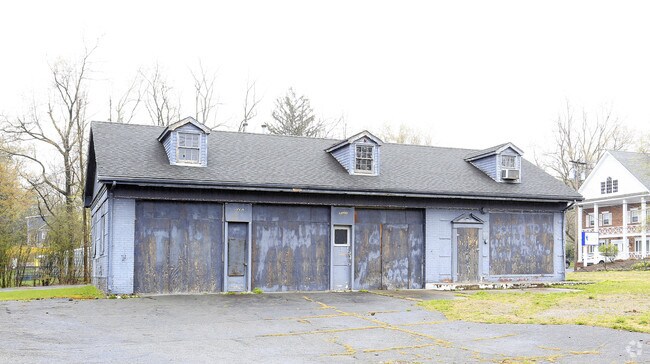
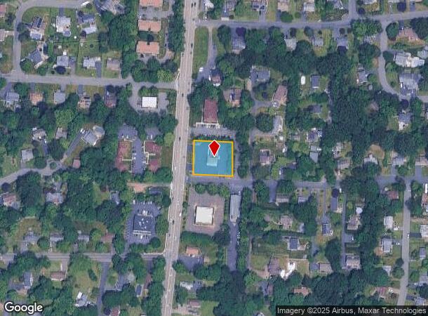
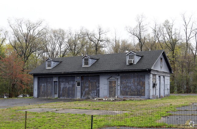
Property Record
10 Johnsons Ln, New City, NY 10956
NEARBY LISTINGS FOR SALE OR LEASE
Property Detail
10 Johnsons Ln
392089-051-011-0004-072-000-0000
56-A-17.2
Officebuilding
Rockland
X
New York
36087C0113G
72.0
2023
0.55 AC
2024
Clarkstown
011403
Northern New Jersey
2,592 SF
New York-Jersey City-White Plains, NY-NJ
DEMOGRAPHICS near 10 Johnsons Ln
1 Mile
3 Mile
5 Mile
2024 Total Population
9,073
89,299
235,933
2029 Population
8,986
88,773
234,283
Pop Growth 2024-2029
(0.96%)
(0.59%)
(0.70%)
Average Age
42
39
36
2024 Total Households
2,954
27,289
68,884
HH Growth 2024-2029
(1.02%)
(0.58%)
(0.73%)
Median Household Inc
$145,771
$105,143
$97,833
Avg Household Size
2.90
3.10
3.20
2024 Avg HH Vehicles
2.00
2.00
2.00
Median Home Value
$583,602
$515,988
$543,444
Median Year Built
1965
1971
1971
Nearby Places
- Restaurants
- Banks
- Shops
- Fitness
- Groceries
PUBLIC TRANSPORTATION
COMMUTER RAIL
Nanuet (Pascack Valley Line - NJ Transit Commuter Rail (NJ Transit))
DRIVE
WALK
Distance
Nanuet (Pascack Valley Line - NJ Transit Commuter Rail (NJ Transit))
8 min
3.8 mi
Spring Valley (Pascack Valley Line - NJ Transit Commuter Rail (NJ Transit))
DRIVE
WALK
Distance
Spring Valley (Pascack Valley Line - NJ Transit Commuter Rail (NJ Transit))
9 min
5.4 mi
AIRPORT
Westchester County
DRIVE
WALK
Distance
Westchester County
36 min
24.8 mi
LaGuardia
DRIVE
WALK
Distance
LaGuardia
52 min
32.9 mi
New York Stewart International
DRIVE
WALK
Distance
New York Stewart International
53 min
36.4 mi
Freight Ports
NY - Red Hook Container Terminal
DRIVE
WALK
Distance
NY - Red Hook Container Terminal
62 min
40.7 mi
Nearby Properties
Address
Land Use
TOTAL SIZE
Lot Size
Zoning
Address
Land Use
TOTAL SIZE
Lot Size
Zoning
402,385 SF
23.10 AC
LI
Address
Land Use
TOTAL SIZE
Lot Size
Zoning
4,540,462 SF
30.89 AC
Address
Land Use
TOTAL SIZE
Lot Size
Zoning
146,101 SF
55 AC
Address
Land Use
TOTAL SIZE
Lot Size
Zoning
37,600 SF
31.41 AC
Address
Land Use
TOTAL SIZE
Lot Size
Zoning
298,975 SF
63.32 AC
03 - MULTI
Address
Land Use
TOTAL SIZE
Lot Size
Zoning
316,644 SF
65.70 AC
Address
Land Use
TOTAL SIZE
Lot Size
Zoning
116,650 SF
39.20 AC
05
Address
Land Use
TOTAL SIZE
Lot Size
Zoning
25.52 AC
Address
Land Use
TOTAL SIZE
Lot Size
Zoning
50,280 SF
24.37 AC
Address
Land Use
TOTAL SIZE
Lot Size
Zoning
247,711 SF
37.26 AC
Address
Land Use
TOTAL SIZE
Lot Size
Zoning
152,854 SF
18.75 AC
RS
Address
Land Use
TOTAL SIZE
Lot Size
Zoning
270,962 SF
21.80 AC
CS
Address
Land Use
TOTAL SIZE
Lot Size
Zoning
247,496 SF
24.20 AC
Address
Land Use
TOTAL SIZE
Lot Size
Zoning
1,887 SF
245.60 AC
02 - SINGL
Address
Land Use
TOTAL SIZE
Lot Size
Zoning
Address
Land Use
TOTAL SIZE
Lot Size
Zoning
208,628 SF
11.95 AC
Address
Land Use
TOTAL SIZE
Lot Size
Zoning
68,910 SF
27 AC
Address
Land Use
TOTAL SIZE
Lot Size
Zoning
500,448 SF
29.92 AC
Address
Land Use
TOTAL SIZE
Lot Size
Zoning
2,220 SF
15.10 AC
02 - SINGL
Address
Land Use
TOTAL SIZE
Lot Size
Zoning
129,957 SF
21.90 AC
Address
Land Use
TOTAL SIZE
Lot Size
Zoning
95,890 SF
60 AC
Address
Land Use
TOTAL SIZE
Lot Size
Zoning
68,910 SF
6.90 AC
02 - SINGL
Address
Land Use
TOTAL SIZE
Lot Size
Zoning
2,140 SF
1.91 AC
Address
Land Use
TOTAL SIZE
Lot Size
Zoning
34.45 AC
Address
Land Use
TOTAL SIZE
Lot Size
Zoning
133,039 SF
14.80 AC
CS
Address
Land Use
TOTAL SIZE
Lot Size
Zoning
60,423 SF
2.90 AC
Address
Land Use
TOTAL SIZE
Lot Size
Zoning
72,930 SF
18.10 AC
02 - SINGL
Address
Land Use
TOTAL SIZE
Lot Size
Zoning
Address
Land Use
TOTAL SIZE
Lot Size
Zoning
129,218 SF
11.56 AC
Address
Land Use
TOTAL SIZE
Lot Size
Zoning
175,948 SF
11.13 AC
The World's #1 Commercial Real Estate Marketplace
Connect with us
© 2025 CoStar Group
The information above has been obtained from sources believed reliable. While we do not doubt its accuracy we have not verified it and make no guarantee, warranty or representation about it. It is your responsibility to independently confirm its accuracy and completeness. Any projections, opinions, assumptions, or estimates used are for example only and do not represent the current or future performance of the property. The value of this transaction to you depends on tax and other factors which should be evaluated by your tax, financial, and legal advisors. You and your advisors should conduct a careful, independent investigation of the property to determine to your satisfaction the suitability of the property for your needs.