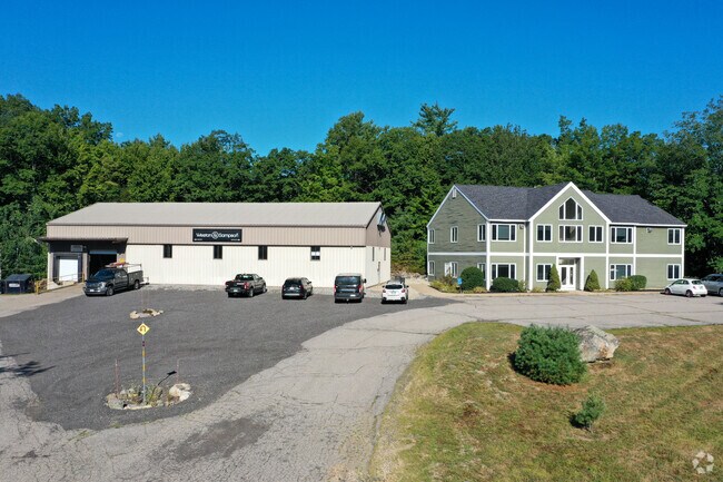
Property Record
10 Lane Rd, Raymond, NH 03077

NEARBY LISTINGS FOR SALE OR LEASE
-
-
View all Raymond listings for lease on LoopNet.com
Property Detail
10 Lane Rd
RAYM-000022-000000-000050
Rockingham
Multipleuses
New Hampshire
X
50
33015C0190E
8.30 AC
2024
Rockingham
2024
Boston
055001
Boston-Cambridge-Newton, MA-NH
6,692 SF
DEMOGRAPHICS near 10 Lane Rd
1 Mile
3 Mile
5 Mile
2024 Total Population
841
11,072
22,668
2029 Population
869
11,497
23,489
Pop Growth 2024-2029
+ 3.33%
+ 3.84%
+ 3.62%
Average Age
41
43
43
2024 Total Households
304
4,360
8,645
HH Growth 2024-2029
+ 3.29%
+ 3.81%
+ 3.59%
Median Household Inc
$127,568
$97,785
$104,548
Avg Household Size
2.60
2.50
2.60
2024 Avg HH Vehicles
3.00
2.00
2.00
Median Home Value
$375,624
$323,022
$356,344
Median Year Built
1984
1983
1984
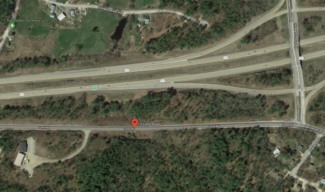
Nearby Places
Map Layers
Map Styles
 Street
 Aerial
- Restaurants
- Banks
- Shops
- Fitness
- Groceries
PUBLIC TRANSPORTATION
AIRPORT
Manchester Boston Regional
DRIVE
WALK
Distance
Manchester Boston Regional
33 min
20.7 mi
Portsmouth International at Pease
DRIVE
WALK
Distance
Portsmouth International at Pease
43 min
26.7 mi
Freight Ports
Port of Boston
DRIVE
WALK
Distance
Port of Boston
90 min
68.4 mi
SALE & LEASE HISTORY
LISTING DATE
SALE/LEASE

Mar 25, 2022
For Lease
Jan 20, 2020
For Lease
Nearby Properties
Address
Land Use
TOTAL SIZE
Lot Size
Zoning
Address
Land Use
TOTAL SIZE
Lot Size
Zoning
220 AC
D
Address
Land Use
TOTAL SIZE
Lot Size
Zoning
134,598 SF
66.30 AC
B
Address
Land Use
TOTAL SIZE
Lot Size
Zoning
103,712 SF
14 AC
Address
Land Use
TOTAL SIZE
Lot Size
Zoning
50,367 SF
13.65 AC
C1
Address
Land Use
TOTAL SIZE
Lot Size
Zoning
25,740 SF
24 AC
C2
Address
Land Use
TOTAL SIZE
Lot Size
Zoning
38,881 SF
22.50 AC
D
Address
Land Use
TOTAL SIZE
Lot Size
Zoning
6,608 SF
95.06 AC
C2
Address
Land Use
TOTAL SIZE
Lot Size
Zoning
79,093 SF
8.95 AC
C1
Address
Land Use
TOTAL SIZE
Lot Size
Zoning
54,154 SF
14 AC
A
Address
Land Use
TOTAL SIZE
Lot Size
Zoning
12,974 SF
8.50 AC
C1
Address
Land Use
TOTAL SIZE
Lot Size
Zoning
936 SF
89 AC
C1
Address
Land Use
TOTAL SIZE
Lot Size
Zoning
3.43 AC
C1
Address
Land Use
TOTAL SIZE
Lot Size
Zoning
1,680 SF
4.98 AC
C1
Address
Land Use
TOTAL SIZE
Lot Size
Zoning
6,600 SF
39.11 AC
C1
Address
Land Use
TOTAL SIZE
Lot Size
Zoning
19,388 SF
1.83 AC
C1
Address
Land Use
TOTAL SIZE
Lot Size
Zoning
8.62 AC
C1
Address
Land Use
TOTAL SIZE
Lot Size
Zoning
18,036 SF
6.70 AC
A
Address
Land Use
TOTAL SIZE
Lot Size
Zoning
10,069 SF
4.50 AC
C1
Address
Land Use
TOTAL SIZE
Lot Size
Zoning
54,840 SF
11.16 AC
D
Address
Land Use
TOTAL SIZE
Lot Size
Zoning
50,160 SF
4.04 AC
D
Address
Land Use
TOTAL SIZE
Lot Size
Zoning
360 SF
50.44 AC
Address
Land Use
TOTAL SIZE
Lot Size
Zoning
3,120 SF
6 AC
B
Address
Land Use
TOTAL SIZE
Lot Size
Zoning
1,920 SF
9.34 AC
C1
Address
Land Use
TOTAL SIZE
Lot Size
Zoning
123.52 AC
D
Address
Land Use
TOTAL SIZE
Lot Size
Zoning
2,808 SF
532.10 AC
D
Address
Land Use
TOTAL SIZE
Lot Size
Zoning
14,478 SF
1.61 AC
C1
Address
Land Use
TOTAL SIZE
Lot Size
Zoning
4,000 SF
19.39 AC
C1
Address
Land Use
TOTAL SIZE
Lot Size
Zoning
25.25 AC
B
Address
Land Use
TOTAL SIZE
Lot Size
Zoning
3,450 SF
78.56 AC
B
Address
Land Use
TOTAL SIZE
Lot Size
Zoning
15,099 SF
3.74 AC
C1
The World's #1 Commercial Real Estate Marketplace
Connect with us
© 2025 CoStar Group
The information above has been obtained from sources believed reliable. While we do not doubt its accuracy we have not verified it and make no guarantee, warranty or representation about it. It is your responsibility to independently confirm its accuracy and completeness. Any projections, opinions, assumptions, or estimates used are for example only and do not represent the current or future performance of the property. The value of this transaction to you depends on tax and other factors which should be evaluated by your tax, financial, and legal advisors. You and your advisors should conduct a careful, independent investigation of the property to determine to your satisfaction the suitability of the property for your needs.