Property Record
10 Litchfield Tpke, New Hartford, CT 06057
NEARBY LISTINGS FOR SALE OR LEASE
-
-
View all New Hartford listings for sale on LoopNet.com
Property Detail
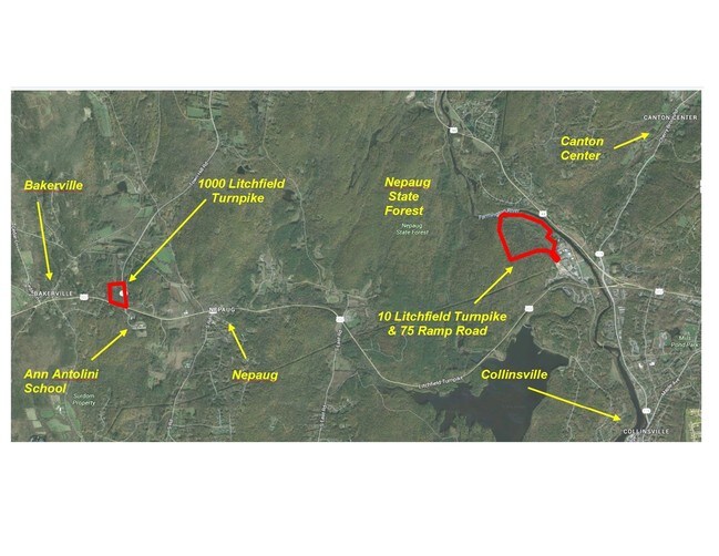
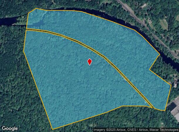
10 Litchfield Tpke
NHAR-000048-000013-000079
Litchfield
Privatepreserveopenspacevacantlandforestlandconservation
Connecticut
AE
79
09003C0304F
119 AC
2025
New Hartford/NE Litchfld
2025
Hartford
306100
Torrington, CT
DEMOGRAPHICS near 10 Litchfield Tpke
1 Mile
3 Mile
5 Mile
2024 Total Population
1,017
10,176
32,448
2029 Population
1,009
10,144
32,317
Pop Growth 2024-2029
(0.79%)
(0.31%)
(0.40%)
Average Age
42
43
42
2024 Total Households
428
4,144
12,311
HH Growth 2024-2029
(0.93%)
(0.43%)
(0.46%)
Median Household Inc
$122,871
$122,695
$137,601
Avg Household Size
2.30
2.40
2.60
2024 Avg HH Vehicles
2.00
2.00
2.00
Median Home Value
$314,762
$365,088
$386,731
Median Year Built
1976
1976
1976
Nearby Places
Map Layers
Map Styles
 Street
 Aerial
- Restaurants
- Banks
- Shops
- Fitness
- Groceries
PUBLIC TRANSPORTATION
AIRPORT
Bradley International
DRIVE
WALK
Distance
Bradley International
44 min
23.0 mi
Freight Ports
Port of New Haven
DRIVE
WALK
Distance
Port of New Haven
61 min
46.2 mi
SALE & LEASE HISTORY
LISTING DATE
SALE/LEASE

Oct 11, 2016
For Sale
Nearby Properties
Address
Land Use
TOTAL SIZE
Lot Size
Zoning
Address
Land Use
TOTAL SIZE
Lot Size
Zoning
172,502 SF
28.04 AC
MCPF
Address
Land Use
TOTAL SIZE
Lot Size
Zoning
87,133 SF
9.25 AC
HCDVD
Address
Land Use
TOTAL SIZE
Lot Size
Zoning
70,929 SF
12.47 AC
MCPF
Address
Land Use
TOTAL SIZE
Lot Size
Zoning
57,510 SF
14 AC
MCPF
Address
Land Use
TOTAL SIZE
Lot Size
Zoning
14,299 SF
6.64 AC
MCPF
Address
Land Use
TOTAL SIZE
Lot Size
Zoning
57,104 SF
7.71 AC
MCPF
Address
Land Use
TOTAL SIZE
Lot Size
Zoning
200,152 SF
21.10 AC
I
Address
Land Use
TOTAL SIZE
Lot Size
Zoning
1,079.49 AC
PS/UD
Address
Land Use
TOTAL SIZE
Lot Size
Zoning
50,076 SF
11.20 AC
AAH
Address
Land Use
TOTAL SIZE
Lot Size
Zoning
52,187 SF
6.27 AC
HCDVD
Address
Land Use
TOTAL SIZE
Lot Size
Zoning
44,985 SF
1.49 AC
HCDVD
Address
Land Use
TOTAL SIZE
Lot Size
Zoning
16,112 SF
5 AC
MCPF
Address
Land Use
TOTAL SIZE
Lot Size
Zoning
23,790 SF
0.34 AC
CVDD
Address
Land Use
TOTAL SIZE
Lot Size
Zoning
52,025 SF
9.59 AC
CVDVD
Address
Land Use
TOTAL SIZE
Lot Size
Zoning
10,424 SF
2.25 AC
CVDVD
Address
Land Use
TOTAL SIZE
Lot Size
Zoning
36,393 SF
6.87 AC
HCDVD
Address
Land Use
TOTAL SIZE
Lot Size
Zoning
39,184 SF
6.96 AC
CSH
Address
Land Use
TOTAL SIZE
Lot Size
Zoning
39.10 AC
R-1.5
Address
Land Use
TOTAL SIZE
Lot Size
Zoning
23,829 SF
7.53 AC
R-15
Address
Land Use
TOTAL SIZE
Lot Size
Zoning
6,578 SF
2.50 AC
R-15
Address
Land Use
TOTAL SIZE
Lot Size
Zoning
18,738 SF
3.96 AC
CVDVD
Address
Land Use
TOTAL SIZE
Lot Size
Zoning
8.91 AC
B2
Address
Land Use
TOTAL SIZE
Lot Size
Zoning
1,774 SF
0.50 AC
CVDD
Address
Land Use
TOTAL SIZE
Lot Size
Zoning
8,498 SF
5 AC
MCPF
Address
Land Use
TOTAL SIZE
Lot Size
Zoning
3.50 AC
I
Address
Land Use
TOTAL SIZE
Lot Size
Zoning
1,624 SF
2.63 AC
I
Address
Land Use
TOTAL SIZE
Lot Size
Zoning
12,000 SF
1.75 AC
CVDVD
Address
Land Use
TOTAL SIZE
Lot Size
Zoning
4.50 AC
CVDVD
Address
Land Use
TOTAL SIZE
Lot Size
Zoning
8,240 SF
499 AC
MCPF
Address
Land Use
TOTAL SIZE
Lot Size
Zoning
38,258 SF
5.70 AC
B-2
The World's #1 Commercial Real Estate Marketplace
Connect with us
© 2025 CoStar Group
The information above has been obtained from sources believed reliable. While we do not doubt its accuracy we have not verified it and make no guarantee, warranty or representation about it. It is your responsibility to independently confirm its accuracy and completeness. Any projections, opinions, assumptions, or estimates used are for example only and do not represent the current or future performance of the property. The value of this transaction to you depends on tax and other factors which should be evaluated by your tax, financial, and legal advisors. You and your advisors should conduct a careful, independent investigation of the property to determine to your satisfaction the suitability of the property for your needs.