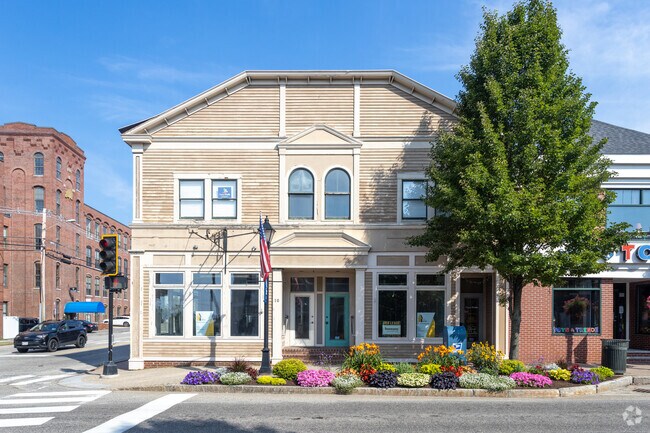
Property Record
10 Main St, Ogunquit, ME 03907
NEARBY LISTINGS FOR SALE OR LEASE
Property Detail
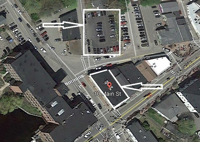
10 Main St
OGUN-000005-000000-000043
York
Taxexempt
Maine
AE
49
23031C0676G
4.05 AC
2025
York County
2025
Portland/South Portland
021000
Portland-South Portland, ME
DEMOGRAPHICS near 10 Main St
1 Mile
3 Mile
5 Mile
2024 Total Population
3,512
11,622
21,021
2029 Population
3,739
12,371
22,516
Pop Growth 2024-2029
+ 6.46%
+ 6.44%
+ 7.11%
Average Age
49
49
49
2024 Total Households
1,675
5,214
9,298
HH Growth 2024-2029
+ 6.39%
+ 6.52%
+ 7.21%
Median Household Inc
$80,077
$81,762
$83,870
Avg Household Size
2.00
2.20
2.20
2024 Avg HH Vehicles
2.00
2.00
2.00
Median Home Value
$347,297
$371,442
$399,821
Median Year Built
1980
1985
1984
Nearby Places
Map Layers
Map Styles
 Street
 Aerial
- Restaurants
- Banks
- Shops
- Fitness
- Groceries
PUBLIC TRANSPORTATION
COMMUTER RAIL
DRIVE
WALK
Distance
17 min
7.2 mi
AIRPORT
Portsmouth International at Pease
DRIVE
WALK
Distance
Portsmouth International at Pease
29 min
17.6 mi
Portland International Jetport
DRIVE
WALK
Distance
Portland International Jetport
52 min
35.4 mi
Freight Ports
Portland, ME
DRIVE
WALK
Distance
Portland, ME
53 min
37.9 mi
SALE & LEASE HISTORY
LISTING DATE
SALE/LEASE

Sep 12, 2019
For Sale
Nearby Properties
Address
Land Use
TOTAL SIZE
Lot Size
Zoning
Address
Land Use
TOTAL SIZE
Lot Size
Zoning
64.25 AC
R2
Address
Land Use
TOTAL SIZE
Lot Size
Zoning
4.10 AC
LB/SLC
Address
Land Use
TOTAL SIZE
Lot Size
Zoning
4.64 AC
SLC/LB
Address
Land Use
TOTAL SIZE
Lot Size
Zoning
3.68 AC
SLC/GB
Address
Land Use
TOTAL SIZE
Lot Size
Zoning
2.63 AC
LBD/SL
Address
Land Use
TOTAL SIZE
Lot Size
Zoning
4,271 SF
4.10 AC
R2
Address
Land Use
TOTAL SIZE
Lot Size
Zoning
1.49 AC
SGD-1
Address
Land Use
TOTAL SIZE
Lot Size
Zoning
1.29 AC
SLR
Address
Land Use
TOTAL SIZE
Lot Size
Zoning
13.33 AC
R1-6
Address
Land Use
TOTAL SIZE
Lot Size
Zoning
4.65 AC
GBD2
Address
Land Use
TOTAL SIZE
Lot Size
Zoning
3.97 AC
GBD2
Address
Land Use
TOTAL SIZE
Lot Size
Zoning
3.78 AC
GBD2/R
Address
Land Use
TOTAL SIZE
Lot Size
Zoning
1.11 AC
LBD
Address
Land Use
TOTAL SIZE
Lot Size
Zoning
5.65 AC
GBD2
Address
Land Use
TOTAL SIZE
Lot Size
Zoning
4.67 AC
GBD2/R
Address
Land Use
TOTAL SIZE
Lot Size
Zoning
2.38 AC
SGD-2
Address
Land Use
TOTAL SIZE
Lot Size
Zoning
6,378 SF
2.46 AC
R2
Address
Land Use
TOTAL SIZE
Lot Size
Zoning
400 SF
0.36 AC
GB02
Address
Land Use
TOTAL SIZE
Lot Size
Zoning
2.07 AC
SLC
Address
Land Use
TOTAL SIZE
Lot Size
Zoning
4,718 SF
2.38 AC
SLR
Address
Land Use
TOTAL SIZE
Lot Size
Zoning
142 AC
RP
Address
Land Use
TOTAL SIZE
Lot Size
Zoning
3.53 AC
SLC/GB
Address
Land Use
TOTAL SIZE
Lot Size
Zoning
1.43 AC
SLC
Address
Land Use
TOTAL SIZE
Lot Size
Zoning
5.43 AC
GBD2/R
Address
Land Use
TOTAL SIZE
Lot Size
Zoning
1.79 AC
SLC
Address
Land Use
TOTAL SIZE
Lot Size
Zoning
24,555 SF
3.50 AC
GB
Address
Land Use
TOTAL SIZE
Lot Size
Zoning
1.83 AC
R2
Address
Land Use
TOTAL SIZE
Lot Size
Zoning
2,264 SF
48.65 AC
GB
Address
Land Use
TOTAL SIZE
Lot Size
Zoning
12.85 AC
SLR/R
Address
Land Use
TOTAL SIZE
Lot Size
Zoning
0.89 AC
SLR/OF
The World's #1 Commercial Real Estate Marketplace
Connect with us
© 2026 CoStar Group
The information above has been obtained from sources believed reliable. While we do not doubt its accuracy we have not verified it and make no guarantee, warranty or representation about it. It is your responsibility to independently confirm its accuracy and completeness. Any projections, opinions, assumptions, or estimates used are for example only and do not represent the current or future performance of the property. The value of this transaction to you depends on tax and other factors which should be evaluated by your tax, financial, and legal advisors. You and your advisors should conduct a careful, independent investigation of the property to determine to your satisfaction the suitability of the property for your needs.