Property Record
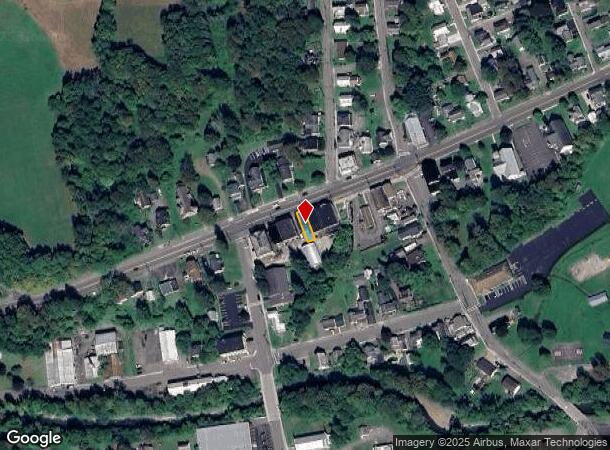
10 Main St, Mc Graw, NY 13101

NEARBY LISTINGS FOR SALE OR LEASE
-
-
View all Mc Graw listings for sale on LoopNet.com
Property Detail
10 Main St
112203-088-019-0001-014-000-0000
Cortland
Commercialofficeresidentialmixeduse
New York
X
14.000
36023C0251D
0.05 AC
2025
Cortland County
2024
Syracuse
970400
Cortland, NY
1,920 SF
DEMOGRAPHICS near 10 Main St
1 Mile
3 Mile
5 Mile
2024 Total Population
992
2,063
18,959
2029 Population
945
1,979
18,660
Pop Growth 2024-2029
(4.74%)
(4.07%)
(1.58%)
Average Age
41
42
38
2024 Total Households
392
816
7,362
HH Growth 2024-2029
(4.85%)
(4.04%)
(1.63%)
Median Household Inc
$57,099
$61,651
$51,960
Avg Household Size
2.50
2.50
2.20
2024 Avg HH Vehicles
2.00
2.00
2.00
Median Home Value
$124,096
$133,802
$136,114
Median Year Built
1953
1957
1949
Nearby Places
- Restaurants
- Banks
- Shops
- Fitness
- Groceries
PUBLIC TRANSPORTATION
AIRPORT
Ithaca Tompkins International
DRIVE
WALK
Distance
Ithaca Tompkins International
40 min
23.9 mi
Freight Ports
Albany, NY Port
DRIVE
WALK
Distance
Albany, NY Port
190 min
150.6 mi
SALE & LEASE HISTORY
LISTING DATE
SALE/LEASE

Jul 27, 2022
For Sale
Nearby Properties
Address
Land Use
TOTAL SIZE
Lot Size
Zoning
Address
Land Use
TOTAL SIZE
Lot Size
Zoning
91,836 SF
15.50 AC
05 - COMME
Address
Land Use
TOTAL SIZE
Lot Size
Zoning
77.10 AC
Address
Land Use
TOTAL SIZE
Lot Size
Zoning
46,137 SF
13.30 AC
05 - COMME
Address
Land Use
TOTAL SIZE
Lot Size
Zoning
15,060 SF
14.04 AC
05 - COMME
Address
Land Use
TOTAL SIZE
Lot Size
Zoning
10.50 AC
04 - FARM
Address
Land Use
TOTAL SIZE
Lot Size
Zoning
33,476 SF
1.80 AC
Address
Land Use
TOTAL SIZE
Lot Size
Zoning
15,640 SF
3.60 AC
04 - FARM
Address
Land Use
TOTAL SIZE
Lot Size
Zoning
7,500 SF
3.60 AC
05 - COMME
Address
Land Use
TOTAL SIZE
Lot Size
Zoning
27,536 SF
4.13 AC
04
Address
Land Use
TOTAL SIZE
Lot Size
Zoning
3,412 SF
79.70 AC
06 - INDUS
Address
Land Use
TOTAL SIZE
Lot Size
Zoning
Address
Land Use
TOTAL SIZE
Lot Size
Zoning
18,700 SF
8.09 AC
05 - COMME
Address
Land Use
TOTAL SIZE
Lot Size
Zoning
2,400 SF
2.30 AC
05 - COMME
Address
Land Use
TOTAL SIZE
Lot Size
Zoning
0.80 AC
R2
Address
Land Use
TOTAL SIZE
Lot Size
Zoning
Address
Land Use
TOTAL SIZE
Lot Size
Zoning
8,400 SF
9.40 AC
04 - FARM
Address
Land Use
TOTAL SIZE
Lot Size
Zoning
9,153 SF
5 AC
05 - COMME
Address
Land Use
TOTAL SIZE
Lot Size
Zoning
5,544 SF
0.38 AC
05 - COMME
Address
Land Use
TOTAL SIZE
Lot Size
Zoning
7,392 SF
1.93 AC
05 - COMME
Address
Land Use
TOTAL SIZE
Lot Size
Zoning
1,900 SF
05 - COMME
Address
Land Use
TOTAL SIZE
Lot Size
Zoning
0.39 AC
B1
Address
Land Use
TOTAL SIZE
Lot Size
Zoning
301.19 AC
04 - FARM
Address
Land Use
TOTAL SIZE
Lot Size
Zoning
Address
Land Use
TOTAL SIZE
Lot Size
Zoning
3,880 SF
1.20 AC
05 - COMME
Address
Land Use
TOTAL SIZE
Lot Size
Zoning
480.80 AC
04 - FARM
Address
Land Use
TOTAL SIZE
Lot Size
Zoning
44.40 AC
06 - INDUS
Address
Land Use
TOTAL SIZE
Lot Size
Zoning
17.61 AC
04 - FARM
Address
Land Use
TOTAL SIZE
Lot Size
Zoning
10,806 SF
0.27 AC
05 - COMME
Address
Land Use
TOTAL SIZE
Lot Size
Zoning
4,560 SF
0.66 AC
05 - COMME
Address
Land Use
TOTAL SIZE
Lot Size
Zoning
6,128 SF
9.90 AC
05 - COMME
The World's #1 Commercial Real Estate Marketplace
Connect with us
© 2025 CoStar Group
The information above has been obtained from sources believed reliable. While we do not doubt its accuracy we have not verified it and make no guarantee, warranty or representation about it. It is your responsibility to independently confirm its accuracy and completeness. Any projections, opinions, assumptions, or estimates used are for example only and do not represent the current or future performance of the property. The value of this transaction to you depends on tax and other factors which should be evaluated by your tax, financial, and legal advisors. You and your advisors should conduct a careful, independent investigation of the property to determine to your satisfaction the suitability of the property for your needs.