Property Record
1 Central St, Middleton, MA 01949
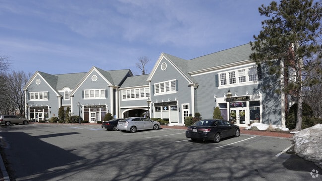

Property Detail
1 Central St
MIDD-000025-000000-000160
Essex
Commercialnec
Massachusetts
B
160
B and X Area of moderate flood hazard, usually the area between the limits of the 100-year and 500-year floods.
1.55 AC
2025
Lawrence/Andover
2025
Boston
212102
Boston-Cambridge-Newton, MA-NH
NEARBY LISTINGS FOR SALE OR LEASE
DEMOGRAPHICS near 1 Central St
1 mile
3 mile
5 mile
2025 Total Population
3,285
25,951
87,313
2030 Population
3,406
26,768
89,844
Pop Growth 2025-2030
+ 3.68%
+ 3.15%
+ 2.90%
Average Age
43
44
44
2025 Total Households
1,113
9,139
32,783
HH Growth 2025-2030
+ 3.59%
+ 3.21%
+ 2.91%
Median Household Inc
$158,429
$146,627
$134,096
Avg Household Size
2.90
2.70
2.60
2025 Avg HH Vehicles
3.00
2.00
2.00
Median Home Value
$791,139
$767,656
$742,498
Median Year Built
1986
1984
1973
Nearby Places
Map Layers
Map Styles
 Street
 Aerial
Transit
 Traffic
 Biking
Places
Listings with unknown addresses are not visible on the map
- Restaurants
- Banks
- Shops
- Fitness
- Groceries
PUBLIC TRANSPORTATION
COMMUTER RAIL
Wakefield (Haverhill Line - Massachusetts Bay Transportation Authority Commuter Rail (Purple Line))
Drive
Walk
Distance
Wakefield (Haverhill Line - Massachusetts Bay Transportation Authority Commuter Rail (Purple Line))
18 min
8.2 mi
North Beverly (Newburyport/Rockport Line - Massachusetts Bay Transportation Authority Commuter Rail (Purple Line))
Drive
Walk
Distance
North Beverly (Newburyport/Rockport Line - Massachusetts Bay Transportation Authority Commuter Rail (Purple Line))
16 min
8.9 mi
AIRPORT
General Edward Lawrence Logan International
Drive
Walk
Distance
General Edward Lawrence Logan International
33 min
19.5 mi
Portsmouth International at Pease
Drive
Walk
Distance
Portsmouth International at Pease
52 min
38.2 mi
Manchester Boston Regional
Drive
Walk
Distance
Manchester Boston Regional
63 min
39.7 mi
SALE & LEASE HISTORY
LISTING DATE
SALE/LEASE

Oct 21, 2025
For Lease
May 31, 2018
For Lease
Mar 30, 2023
For Lease
Mar 23, 2021
For Lease
Nearby Properties
Address
Land Use
TOTAL SIZE
Lot Size
Zoning
Address
Land Use
TOTAL SIZE
Lot Size
Zoning
747,237 SF
36.70 AC
HW
Address
Land Use
TOTAL SIZE
Lot Size
Zoning
198.74 AC
R3
Address
Land Use
TOTAL SIZE
Lot Size
Zoning
13.04 AC
HC
Address
Land Use
TOTAL SIZE
Lot Size
Zoning
101,389 SF
20 AC
I
Address
Land Use
TOTAL SIZE
Lot Size
Zoning
65.79 AC
I1
Address
Land Use
TOTAL SIZE
Lot Size
Zoning
40.20 AC
R1B
Address
Land Use
TOTAL SIZE
Lot Size
Zoning
54,302 SF
83.70 AC
R3
Address
Land Use
TOTAL SIZE
Lot Size
Zoning
93,789 SF
8.22 AC
HW
Address
Land Use
TOTAL SIZE
Lot Size
Zoning
15.32 AC
HC
Address
Land Use
TOTAL SIZE
Lot Size
Zoning
71.68 AC
R3
Address
Land Use
TOTAL SIZE
Lot Size
Zoning
12.57 AC
IH
Address
Land Use
TOTAL SIZE
Lot Size
Zoning
24.54 AC
M1
Address
Land Use
TOTAL SIZE
Lot Size
Zoning
36,156 SF
754.25 AC
R1A
Address
Land Use
TOTAL SIZE
Lot Size
Zoning
81,746 SF
10.50 AC
R1A
Address
Land Use
TOTAL SIZE
Lot Size
Zoning
24.87 AC
R3
Address
Land Use
TOTAL SIZE
Lot Size
Zoning
175,699 SF
22.91 AC
R3
Address
Land Use
TOTAL SIZE
Lot Size
Zoning
114,680 SF
13.73 AC
HC
Address
Land Use
TOTAL SIZE
Lot Size
Zoning
8.60 AC
I1
Address
Land Use
TOTAL SIZE
Lot Size
Zoning
351,796 SF
37.30 AC
M1
Address
Land Use
TOTAL SIZE
Lot Size
Zoning
117,214 SF
8.49 AC
R1B
Address
Land Use
TOTAL SIZE
Lot Size
Zoning
12.73 AC
IH
Address
Land Use
TOTAL SIZE
Lot Size
Zoning
72,600 SF
4.01 AC
B
Address
Land Use
TOTAL SIZE
Lot Size
Zoning
59,514 SF
10.40 AC
B
Address
Land Use
TOTAL SIZE
Lot Size
Zoning
Address
Land Use
TOTAL SIZE
Lot Size
Zoning
128,666 SF
8.48 AC
I2
Address
Land Use
TOTAL SIZE
Lot Size
Zoning
5.58 AC
HC
Address
Land Use
TOTAL SIZE
Lot Size
Zoning
94,999 SF
B1A
Address
Land Use
TOTAL SIZE
Lot Size
Zoning
77 AC
I
Address
Land Use
TOTAL SIZE
Lot Size
Zoning
121,000 SF
2.33 AC
I1
Address
Land Use
TOTAL SIZE
Lot Size
Zoning
79,616 SF
M1
The World's #1 Commercial Real Estate Marketplace
Connect with us
© 2026 CoStar Group
The information above has been obtained from sources believed reliable. While we do not doubt its accuracy we have not verified it and make no guarantee, warranty or representation about it. It is your responsibility to independently confirm its accuracy and completeness. Any projections, opinions, assumptions, or estimates used are for example only and do not represent the current or future performance of the property. The value of this transaction to you depends on tax and other factors which should be evaluated by your tax, financial, and legal advisors. You and your advisors should conduct a careful, independent investigation of the property to determine to your satisfaction the suitability of the property for your needs.