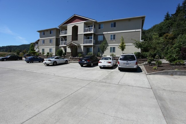
Property Record
10 Monohon Landing Rd, Raymond, WA 98577
NEARBY LISTINGS FOR SALE OR LEASE
-
-
View all Raymond listings for sale on LoopNet.com
Property Detail
10 Monohon Landing Rd
72052013001
Riverside Replat
Multifamilydwelling
RIVERSIDE REPLAT, LOTS 1-16, BLOCK L; LESS RD & R/W
X
Pacific
53049C0255D
Washington
2024
1-16
2025
1.07 AC
950200
Other Market Areas
40,998 SF
DEMOGRAPHICS near 10 Monohon Landing Rd
1 Mile
3 Mile
5 Mile
2024 Total Population
1,866
5,052
6,727
2029 Population
2,051
5,468
7,240
Pop Growth 2024-2029
+ 9.91%
+ 8.23%
+ 7.63%
Average Age
41
42
42
2024 Total Households
775
2,012
2,676
HH Growth 2024-2029
+ 9.42%
+ 7.85%
+ 7.17%
Median Household Inc
$45,857
$62,536
$60,859
Avg Household Size
2.40
2.40
2.40
2024 Avg HH Vehicles
2.00
2.00
2.00
Median Home Value
$126,288
$199,999
$202,749
Median Year Built
1972
1967
1965
Nearby Places
Map Layers
Map Styles
 Street
 Aerial
- Restaurants
- Banks
- Shops
- Fitness
- Groceries
Nearby Properties
Address
Land Use
TOTAL SIZE
Lot Size
Zoning
Address
Land Use
TOTAL SIZE
Lot Size
Zoning
69.69 AC
UGA
Address
Land Use
TOTAL SIZE
Lot Size
Zoning
36,433 SF
0.69 AC
UGA
Address
Land Use
TOTAL SIZE
Lot Size
Zoning
44,011 SF
4.17 AC
UGA
Address
Land Use
TOTAL SIZE
Lot Size
Zoning
69,236 SF
9.75 AC
UGA
Address
Land Use
TOTAL SIZE
Lot Size
Zoning
16,924 SF
3.22 AC
UGA
Address
Land Use
TOTAL SIZE
Lot Size
Zoning
1,400 SF
1.61 AC
UGA
Address
Land Use
TOTAL SIZE
Lot Size
Zoning
20,928 SF
1.39 AC
UGA
Address
Land Use
TOTAL SIZE
Lot Size
Zoning
25,014 SF
0.53 AC
UGA
Address
Land Use
TOTAL SIZE
Lot Size
Zoning
2,510 SF
1.23 AC
UGA
Address
Land Use
TOTAL SIZE
Lot Size
Zoning
11,208 SF
1.81 AC
UGA
Address
Land Use
TOTAL SIZE
Lot Size
Zoning
28,739 SF
1.03 AC
UGA
Address
Land Use
TOTAL SIZE
Lot Size
Zoning
5,846 SF
0.76 AC
UGA
Address
Land Use
TOTAL SIZE
Lot Size
Zoning
29,013 SF
0.79 AC
UGA
Address
Land Use
TOTAL SIZE
Lot Size
Zoning
39,144 SF
0.83 AC
UGA
Address
Land Use
TOTAL SIZE
Lot Size
Zoning
3,308 SF
1.06 AC
UGA
Address
Land Use
TOTAL SIZE
Lot Size
Zoning
10,032 SF
0.53 AC
UGA
Address
Land Use
TOTAL SIZE
Lot Size
Zoning
16,000 SF
1 AC
Address
Land Use
TOTAL SIZE
Lot Size
Zoning
4,885 SF
32.90 AC
UGA
Address
Land Use
TOTAL SIZE
Lot Size
Zoning
6,614 SF
7.01 AC
Address
Land Use
TOTAL SIZE
Lot Size
Zoning
0.25 AC
UGA
Address
Land Use
TOTAL SIZE
Lot Size
Zoning
49,600 SF
5 AC
UGA
Address
Land Use
TOTAL SIZE
Lot Size
Zoning
12,300 SF
0.41 AC
UGA
Address
Land Use
TOTAL SIZE
Lot Size
Zoning
19,832 SF
0.37 AC
UGA
Address
Land Use
TOTAL SIZE
Lot Size
Zoning
5,320 SF
28.28 AC
R
Address
Land Use
TOTAL SIZE
Lot Size
Zoning
2,661 SF
1.71 AC
Address
Land Use
TOTAL SIZE
Lot Size
Zoning
5,968 SF
0.48 AC
UGA
Address
Land Use
TOTAL SIZE
Lot Size
Zoning
6,424 SF
0.27 AC
UGA
Address
Land Use
TOTAL SIZE
Lot Size
Zoning
5,952 SF
0.32 AC
UGA
Address
Land Use
TOTAL SIZE
Lot Size
Zoning
2,616 SF
19.46 AC
R
The World's #1 Commercial Real Estate Marketplace
Connect with us
© 2026 CoStar Group
The information above has been obtained from sources believed reliable. While we do not doubt its accuracy we have not verified it and make no guarantee, warranty or representation about it. It is your responsibility to independently confirm its accuracy and completeness. Any projections, opinions, assumptions, or estimates used are for example only and do not represent the current or future performance of the property. The value of this transaction to you depends on tax and other factors which should be evaluated by your tax, financial, and legal advisors. You and your advisors should conduct a careful, independent investigation of the property to determine to your satisfaction the suitability of the property for your needs.