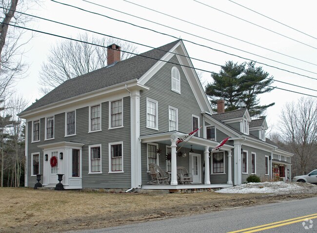
Property Record
10 Mountain Rd, Cape Neddick, ME 03902


NEARBY LISTINGS FOR SALE OR LEASE
Property Detail
10 Mountain Rd
Departmentstore
York
X
Maine
23031C0678G
2.16 AC
2024
York County
2024
Portland/South Portland
036002
Portland-South Portland, ME
4,959 SF
YORK-000097-000000-000012
DEMOGRAPHICS near 10 Mountain Rd
1 Mile
3 Mile
5 Mile
2024 Total Population
571
6,313
12,457
2029 Population
602
6,659
13,043
Pop Growth 2024-2029
+ 5.43%
+ 5.48%
+ 4.70%
Average Age
48
48
49
2024 Total Households
255
2,763
5,515
HH Growth 2024-2029
+ 5.10%
+ 5.36%
+ 4.50%
Median Household Inc
$82,031
$104,247
$96,459
Avg Household Size
2.20
2.30
2.20
2024 Avg HH Vehicles
2.00
2.00
2.00
Median Home Value
$644,309
$519,358
$518,142
Median Year Built
1959
1973
1976
Nearby Places
Map Layers
Map Styles
 Street
 Aerial
- Restaurants
- Banks
- Shops
- Fitness
- Groceries
PUBLIC TRANSPORTATION
AIRPORT
Portsmouth International at Pease
DRIVE
WALK
Distance
Portsmouth International at Pease
24 min
14.6 mi
Portland International Jetport
DRIVE
WALK
Distance
Portland International Jetport
56 min
44.3 mi
SALE & LEASE HISTORY
LISTING DATE
SALE/LEASE

Sep 24, 2016
For Sale
Nearby Properties
Address
Land Use
TOTAL SIZE
Lot Size
Zoning
Address
Land Use
TOTAL SIZE
Lot Size
Zoning
64.25 AC
R2
Address
Land Use
TOTAL SIZE
Lot Size
Zoning
5.82 AC
R7
Address
Land Use
TOTAL SIZE
Lot Size
Zoning
4,271 SF
4.10 AC
R2
Address
Land Use
TOTAL SIZE
Lot Size
Zoning
53,579 SF
1.78 AC
B1
Address
Land Use
TOTAL SIZE
Lot Size
Zoning
13.33 AC
R1-6
Address
Land Use
TOTAL SIZE
Lot Size
Zoning
5,335 SF
2.85 AC
R4
Address
Land Use
TOTAL SIZE
Lot Size
Zoning
2,232 SF
58.62 AC
RT1
Address
Land Use
TOTAL SIZE
Lot Size
Zoning
272 AC
G2
Address
Land Use
TOTAL SIZE
Lot Size
Zoning
6,378 SF
2.46 AC
R2
Address
Land Use
TOTAL SIZE
Lot Size
Zoning
400 SF
0.36 AC
GB02
Address
Land Use
TOTAL SIZE
Lot Size
Zoning
2,400 SF
29.13 AC
G2
Address
Land Use
TOTAL SIZE
Lot Size
Zoning
4,718 SF
2.38 AC
SLR
Address
Land Use
TOTAL SIZE
Lot Size
Zoning
7,674 SF
1.64 AC
R4
Address
Land Use
TOTAL SIZE
Lot Size
Zoning
1.89 AC
R4
Address
Land Use
TOTAL SIZE
Lot Size
Zoning
6,696 SF
2 AC
R7
Address
Land Use
TOTAL SIZE
Lot Size
Zoning
1.69 AC
R5
Address
Land Use
TOTAL SIZE
Lot Size
Zoning
1.83 AC
R2
Address
Land Use
TOTAL SIZE
Lot Size
Zoning
9,214 SF
2.15 AC
R5
Address
Land Use
TOTAL SIZE
Lot Size
Zoning
1.94 AC
B1
Address
Land Use
TOTAL SIZE
Lot Size
Zoning
25,061 SF
0.40 AC
B3
Address
Land Use
TOTAL SIZE
Lot Size
Zoning
1.02 AC
R5
Address
Land Use
TOTAL SIZE
Lot Size
Zoning
924 SF
2.80 AC
R5
Address
Land Use
TOTAL SIZE
Lot Size
Zoning
0.73 AC
R5
Address
Land Use
TOTAL SIZE
Lot Size
Zoning
7,728 SF
3 AC
SLC
Address
Land Use
TOTAL SIZE
Lot Size
Zoning
1.30 AC
R2
Address
Land Use
TOTAL SIZE
Lot Size
Zoning
19,126 SF
0.24 AC
B3
Address
Land Use
TOTAL SIZE
Lot Size
Zoning
8.88 AC
R6
Address
Land Use
TOTAL SIZE
Lot Size
Zoning
1.88 AC
R2
Address
Land Use
TOTAL SIZE
Lot Size
Zoning
19,215 SF
0.86 AC
R7
Address
Land Use
TOTAL SIZE
Lot Size
Zoning
2.08 AC
R7
The World's #1 Commercial Real Estate Marketplace
Connect with us
© 2025 CoStar Group
The information above has been obtained from sources believed reliable. While we do not doubt its accuracy we have not verified it and make no guarantee, warranty or representation about it. It is your responsibility to independently confirm its accuracy and completeness. Any projections, opinions, assumptions, or estimates used are for example only and do not represent the current or future performance of the property. The value of this transaction to you depends on tax and other factors which should be evaluated by your tax, financial, and legal advisors. You and your advisors should conduct a careful, independent investigation of the property to determine to your satisfaction the suitability of the property for your needs.