Property Record
10 N Main St, Yardley, PA 19067

Save to a Folder
{{folder.Name}}
{{folder.ListingIds.length}} Properties
{{folder.ListingIds.length}} Property
Create a New Folder
Current Lease Availabilities
Property Detail
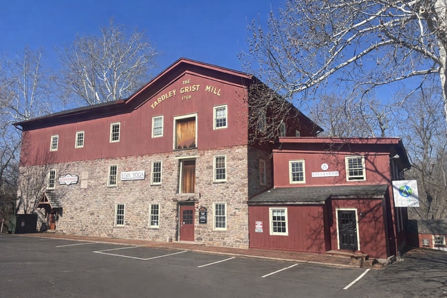
10 N Main St
45-003-017
WS N MAIN ST 167 FT N OF W BROAD ST 64X225
Multifamilydwelling
BUCKS
CC
Pennsylvania
B and X Area of moderate flood hazard, usually the area between the limits of the 100-year and 500-year floods.
0.31 AC
2025
Lower Bucks County
2026
Philadelphia
105600
Philadelphia-Camden-Wilmington, PA-NJ-DE-MD
3,277 SF
NEARBY LISTINGS FOR SALE OR LEASE
DEMOGRAPHICS near 10 N Main St
1 mile
3 mile
5 mile
2025 Total Population
6,968
56,974
176,009
2030 Population
6,979
58,052
180,190
Pop Growth 2025-2030
+ 0.16%
+ 1.89%
+ 2.38%
Average Age
45
44
42
2025 Total Households
3,021
22,359
67,756
HH Growth 2025-2030
+ 0.26%
+ 2.49%
+ 2.61%
Median Household Inc
$127,434
$114,409
$91,991
Avg Household Size
2.30
2.40
2.50
2025 Avg HH Vehicles
2.00
2.00
2.00
Median Home Value
$608,850
$494,746
$418,817
Median Year Built
1965
1971
1964
Nearby Places
Map Layers
Map Styles
 Street
 Aerial
Layers
 Traffic
 Biking
Places
Listings with unknown addresses are not visible on the map
- Restaurants
- Banks
- Shops
- Fitness
- Groceries
PUBLIC TRANSPORTATION
AIRPORT
Lehigh Valley International
Drive
Walk
Distance
Lehigh Valley International
37 min
20.4 mi
Trenton Mercer
Drive
Walk
Distance
Trenton Mercer
69 min
39.5 mi
Freight Ports
Port of Philadelphia
Drive
Walk
Distance
Port of Philadelphia
61 min
42.7 mi
Nearby Properties
Address
Land Use
TOTAL SIZE
Lot Size
Zoning
Address
Land Use
TOTAL SIZE
Lot Size
Zoning
242,141 SF
61.72 AC
PC
Address
Land Use
TOTAL SIZE
Lot Size
Zoning
203,923 SF
34.17 AC
HC
Address
Land Use
TOTAL SIZE
Lot Size
Zoning
157,360 SF
17.34 AC
SRC
Address
Land Use
TOTAL SIZE
Lot Size
Zoning
264,600 SF
33.38 AC
PI
Address
Land Use
TOTAL SIZE
Lot Size
Zoning
14,450 SF
7.16 AC
R4
Address
Land Use
TOTAL SIZE
Lot Size
Zoning
1 SF
15.66 AC
PC
Address
Land Use
TOTAL SIZE
Lot Size
Zoning
215,368 SF
24.49 AC
SRM
Address
Land Use
TOTAL SIZE
Lot Size
Zoning
208,937 SF
20.07 AC
PC
Address
Land Use
TOTAL SIZE
Lot Size
Zoning
67,443 SF
1.97 AC
NC
Address
Land Use
TOTAL SIZE
Lot Size
Zoning
58,391 SF
9.45 AC
PC
Address
Land Use
TOTAL SIZE
Lot Size
Zoning
4.22 AC
R4
Address
Land Use
TOTAL SIZE
Lot Size
Zoning
117,432 SF
11.92 AC
PI
Address
Land Use
TOTAL SIZE
Lot Size
Zoning
36,450 SF
3.09 AC
HC
Address
Land Use
TOTAL SIZE
Lot Size
Zoning
125,000 SF
19.58 AC
PI
Address
Land Use
TOTAL SIZE
Lot Size
Zoning
12,734 SF
4.68 AC
HC
Address
Land Use
TOTAL SIZE
Lot Size
Zoning
48,457 SF
2.73 AC
PC
Address
Land Use
TOTAL SIZE
Lot Size
Zoning
53,124 SF
3.37 AC
PC
Address
Land Use
TOTAL SIZE
Lot Size
Zoning
83,508 SF
7.91 AC
PI
Address
Land Use
TOTAL SIZE
Lot Size
Zoning
42,417 SF
6.13 AC
PC
Address
Land Use
TOTAL SIZE
Lot Size
Zoning
89,012 SF
29.93 AC
PI
Address
Land Use
TOTAL SIZE
Lot Size
Zoning
32,270 SF
17.95 AC
PC
Address
Land Use
TOTAL SIZE
Lot Size
Zoning
75,408 SF
9.63 AC
PI
Address
Land Use
TOTAL SIZE
Lot Size
Zoning
46,579 SF
5.13 AC
HR
Address
Land Use
TOTAL SIZE
Lot Size
Zoning
86,854 SF
9.64 AC
HC
Address
Land Use
TOTAL SIZE
Lot Size
Zoning
22,150 SF
2.54 AC
R2
Address
Land Use
TOTAL SIZE
Lot Size
Zoning
144,197 SF
5.38 AC
H
Address
Land Use
TOTAL SIZE
Lot Size
Zoning
58,942 SF
5.97 AC
PC
Address
Land Use
TOTAL SIZE
Lot Size
Zoning
11.06 AC
PI
Address
Land Use
TOTAL SIZE
Lot Size
Zoning
82,753 SF
7.85 AC
PC
Address
Land Use
TOTAL SIZE
Lot Size
Zoning
61,970 SF
10.19 AC
RA
The World's #1 Commercial Real Estate Marketplace
Connect with us
© 2026 CoStar Group
The information above has been obtained from sources believed reliable. While we do not doubt its accuracy we have not verified it and make no guarantee, warranty or representation about it. It is your responsibility to independently confirm its accuracy and completeness. Any projections, opinions, assumptions, or estimates used are for example only and do not represent the current or future performance of the property. The value of this transaction to you depends on tax and other factors which should be evaluated by your tax, financial, and legal advisors. You and your advisors should conduct a careful, independent investigation of the property to determine to your satisfaction the suitability of the property for your needs.