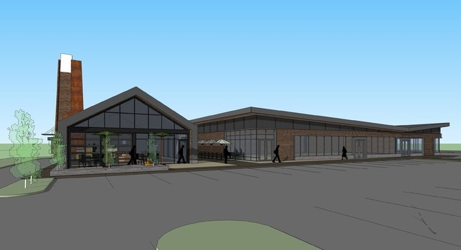
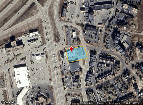
Property Record
10 N Mile Cir, Frisco, CO 80443
NEARBY LISTINGS FOR SALE OR LEASE
Property Detail
10 N Mile Cir
Breckenridge, CO
Lakepoint At Frisco
6516433
LOT R3-1 BLOCK 1 LAKEPOINT AT FRISCO SUB RESUB LOTS R2 & R3
Commercialacreage
Summit
X
Colorado
08117C0353F
r3,r2
2023
0.95 AC
2024
Colorado Ski Area
000302
Other Market Areas
7,501 SF
DEMOGRAPHICS near 10 N Mile Cir
1 Mile
3 Mile
5 Mile
2024 Total Population
1,304
5,863
17,942
2029 Population
1,249
5,639
17,585
Pop Growth 2024-2029
(4.22%)
(3.82%)
(1.99%)
Average Age
45
41
39
2024 Total Households
637
2,602
7,342
HH Growth 2024-2029
(3.92%)
(3.65%)
(1.87%)
Median Household Inc
$118,095
$86,851
$95,893
Avg Household Size
1.90
2.10
2.40
2024 Avg HH Vehicles
2.00
2.00
2.00
Median Home Value
$716,718
$664,641
$733,595
Median Year Built
1989
1986
1990
Nearby Places
Map Layers
Map Styles
 Street
 Aerial
- Restaurants
- Banks
- Shops
- Fitness
- Groceries
SALE & LEASE HISTORY
LISTING DATE
SALE/LEASE

Sep 25, 2016
For Lease
Nov 19, 2018
For Sale
Nearby Properties
Address
Land Use
TOTAL SIZE
Lot Size
Zoning
Address
Land Use
TOTAL SIZE
Lot Size
Zoning
31,068 SF
3.79 AC
Address
Land Use
TOTAL SIZE
Lot Size
Zoning
58,527 SF
2.58 AC
C-1
Address
Land Use
TOTAL SIZE
Lot Size
Zoning
127,470 SF
4.43 AC
FGW
Address
Land Use
TOTAL SIZE
Lot Size
Zoning
111,644 SF
11.08 AC
C-1
Address
Land Use
TOTAL SIZE
Lot Size
Zoning
83,981 SF
2.99 AC
FGW
Address
Land Use
TOTAL SIZE
Lot Size
Zoning
76,047 SF
3.81 AC
SC-2
Address
Land Use
TOTAL SIZE
Lot Size
Zoning
32,423 SF
FGW
Address
Land Use
TOTAL SIZE
Lot Size
Zoning
43,660 SF
3.58 AC
C-1
Address
Land Use
TOTAL SIZE
Lot Size
Zoning
22,565 SF
3.71 AC
PUD
Address
Land Use
TOTAL SIZE
Lot Size
Zoning
74,964 SF
5.60 AC
CO
Address
Land Use
TOTAL SIZE
Lot Size
Zoning
4,932 SF
0.56 AC
CC
Address
Land Use
TOTAL SIZE
Lot Size
Zoning
28,280 SF
5.61 AC
C-1
Address
Land Use
TOTAL SIZE
Lot Size
Zoning
29,521 SF
0.58 AC
STC
Address
Land Use
TOTAL SIZE
Lot Size
Zoning
15,620 SF
1.60 AC
CO
Address
Land Use
TOTAL SIZE
Lot Size
Zoning
14,403 SF
FGW
Address
Land Use
TOTAL SIZE
Lot Size
Zoning
21,894 SF
FGW
Address
Land Use
TOTAL SIZE
Lot Size
Zoning
4,900 SF
1.23 AC
C-1
Address
Land Use
TOTAL SIZE
Lot Size
Zoning
13,773 SF
1.96 AC
R-6
Address
Land Use
TOTAL SIZE
Lot Size
Zoning
31,768 SF
1.49 AC
C-1
Address
Land Use
TOTAL SIZE
Lot Size
Zoning
15,441 SF
1.07 AC
PUD
Address
Land Use
TOTAL SIZE
Lot Size
Zoning
10,412 SF
11.54 AC
PUD
Address
Land Use
TOTAL SIZE
Lot Size
Zoning
20,200 SF
1.29 AC
PUD
Address
Land Use
TOTAL SIZE
Lot Size
Zoning
3.80 AC
FLI
Address
Land Use
TOTAL SIZE
Lot Size
Zoning
19,983 SF
4.99 AC
SC-2
Address
Land Use
TOTAL SIZE
Lot Size
Zoning
9,896 SF
4.05 AC
PUD
Address
Land Use
TOTAL SIZE
Lot Size
Zoning
2,460 SF
2.48 AC
FLI
Address
Land Use
TOTAL SIZE
Lot Size
Zoning
4,521 SF
1.48 AC
C-1
Address
Land Use
TOTAL SIZE
Lot Size
Zoning
1 AC
MU
Address
Land Use
TOTAL SIZE
Lot Size
Zoning
46,899 SF
2.72 AC
CO
Address
Land Use
TOTAL SIZE
Lot Size
Zoning
8,547 SF
4.05 AC
PUD
The World's #1 Commercial Real Estate Marketplace
Connect with us
© 2026 CoStar Group
The information above has been obtained from sources believed reliable. While we do not doubt its accuracy we have not verified it and make no guarantee, warranty or representation about it. It is your responsibility to independently confirm its accuracy and completeness. Any projections, opinions, assumptions, or estimates used are for example only and do not represent the current or future performance of the property. The value of this transaction to you depends on tax and other factors which should be evaluated by your tax, financial, and legal advisors. You and your advisors should conduct a careful, independent investigation of the property to determine to your satisfaction the suitability of the property for your needs.