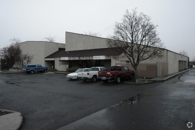
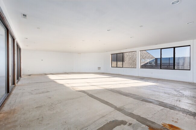
Property Record
10 N Washington St, Kennewick, WA 99336

Current Lease Availabilities
NEARBY LISTINGS FOR SALE OR LEASE
Property Detail
10 N Washington St
Other Market Areas
Beachs First Addition To Kennewick
Kennewick-Richland, WA
BEACHS FIRST ADDITION TO KENNEWICK BLOCK 7 ALL THOSE PORTIONS OF BLOCKS 1 AND 7 OF THE ALLEY IN SAID BLOCK 7 AND OF VACATED EAST AVENUE A TOGETHER BOUNDED AND DESCRIBED AS FOLLOWS LAND ONLY AND BUILDING ON NORTH SIDE OF PEOPLES BANK MALL ALL THOSE
106802040007001
Benton
Storebuilding
Washington
2024
1.21 AC
2024
Yakima/Kennewick
011300
DEMOGRAPHICS near 10 N Washington St
1 Mile
3 Mile
5 Mile
2024 Total Population
9,009
83,236
140,187
2029 Population
9,671
89,624
151,009
Pop Growth 2024-2029
+ 7.35%
+ 7.67%
+ 7.72%
Average Age
35
35
36
2024 Total Households
3,220
27,538
46,867
HH Growth 2024-2029
+ 7.36%
+ 7.69%
+ 7.74%
Median Household Inc
$41,360
$59,253
$68,585
Avg Household Size
2.70
2.90
2.90
2024 Avg HH Vehicles
2.00
2.00
2.00
Median Home Value
$207,952
$263,159
$305,526
Median Year Built
1963
1972
1977
Nearby Places
Map Layers
Map Styles
 Street
 Aerial
- Restaurants
- Banks
- Shops
- Fitness
- Groceries
PUBLIC TRANSPORTATION
AIRPORT
Tri-Cities
DRIVE
WALK
Distance
Tri-Cities
10 min
5.1 mi
Nearby Properties
Address
Land Use
TOTAL SIZE
Lot Size
Zoning
Address
Land Use
TOTAL SIZE
Lot Size
Zoning
2,863,808 SF
28.33 AC
Address
Land Use
TOTAL SIZE
Lot Size
Zoning
294,855 SF
35.04 AC
KENNEWICK
Address
Land Use
TOTAL SIZE
Lot Size
Zoning
377,541 SF
24.58 AC
Address
Land Use
TOTAL SIZE
Lot Size
Zoning
153,320 SF
7.37 AC
Address
Land Use
TOTAL SIZE
Lot Size
Zoning
113,585 SF
15.43 AC
Address
Land Use
TOTAL SIZE
Lot Size
Zoning
114,673 SF
6.58 AC
Address
Land Use
TOTAL SIZE
Lot Size
Zoning
84,951 SF
4.39 AC
Address
Land Use
TOTAL SIZE
Lot Size
Zoning
172,573 SF
15.30 AC
Address
Land Use
TOTAL SIZE
Lot Size
Zoning
84,680 SF
3 AC
Address
Land Use
TOTAL SIZE
Lot Size
Zoning
61,400 SF
11.50 AC
Address
Land Use
TOTAL SIZE
Lot Size
Zoning
164,172 SF
9.37 AC
35
Address
Land Use
TOTAL SIZE
Lot Size
Zoning
67,635 SF
5.95 AC
Address
Land Use
TOTAL SIZE
Lot Size
Zoning
55,841 SF
12.30 AC
Address
Land Use
TOTAL SIZE
Lot Size
Zoning
86,190 SF
30.10 AC
Address
Land Use
TOTAL SIZE
Lot Size
Zoning
149,281 SF
10.79 AC
Address
Land Use
TOTAL SIZE
Lot Size
Zoning
67,748 SF
3.87 AC
Address
Land Use
TOTAL SIZE
Lot Size
Zoning
241,912 SF
12.99 AC
Address
Land Use
TOTAL SIZE
Lot Size
Zoning
110,740 SF
18.15 AC
Address
Land Use
TOTAL SIZE
Lot Size
Zoning
584,810 SF
Address
Land Use
TOTAL SIZE
Lot Size
Zoning
55,809 SF
10.79 AC
Address
Land Use
TOTAL SIZE
Lot Size
Zoning
20,919 SF
58.49 AC
KENNEWICK
Address
Land Use
TOTAL SIZE
Lot Size
Zoning
103,115 SF
8.38 AC
Address
Land Use
TOTAL SIZE
Lot Size
Zoning
47,064 SF
13.70 AC
KENNEWICK
Address
Land Use
TOTAL SIZE
Lot Size
Zoning
75,542 SF
6.36 AC
Address
Land Use
TOTAL SIZE
Lot Size
Zoning
125,508 SF
3.49 AC
Address
Land Use
TOTAL SIZE
Lot Size
Zoning
114,726 SF
7.59 AC
Address
Land Use
TOTAL SIZE
Lot Size
Zoning
101,720 SF
4.92 AC
33
Address
Land Use
TOTAL SIZE
Lot Size
Zoning
86,712 SF
4.15 AC
Address
Land Use
TOTAL SIZE
Lot Size
Zoning
147,847 SF
8.47 AC
Address
Land Use
TOTAL SIZE
Lot Size
Zoning
106,634 SF
12.35 AC
KENNEWICK
The World's #1 Commercial Real Estate Marketplace
Connect with us
© 2026 CoStar Group
The information above has been obtained from sources believed reliable. While we do not doubt its accuracy we have not verified it and make no guarantee, warranty or representation about it. It is your responsibility to independently confirm its accuracy and completeness. Any projections, opinions, assumptions, or estimates used are for example only and do not represent the current or future performance of the property. The value of this transaction to you depends on tax and other factors which should be evaluated by your tax, financial, and legal advisors. You and your advisors should conduct a careful, independent investigation of the property to determine to your satisfaction the suitability of the property for your needs.