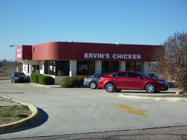
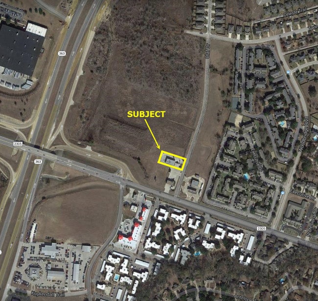
Property Record
10 Olaf Dr, Temple, TX 76504

Property Detail
10 Olaf Dr
Killeen-Temple, TX
WOODBRIDGE SUBDIVISION PHASE VI, BLOCK 001, LOT 0001, ERVINS CHICKEN
185979
Bell
Commercialnec
Texas
B and X Area of moderate flood hazard, usually the area between the limits of the 100-year and 500-year floods.
1
2025
0.53 AC
2025
Temple
021201
Killeen/Temple/Fort Hood
2,663 SF
NEARBY LISTINGS FOR SALE OR LEASE
DEMOGRAPHICS near 10 Olaf Dr
1 mile
3 mile
5 mile
2024 Total Population
8,768
46,996
96,130
2029 Population
9,297
50,165
102,665
Pop Growth 2024-2029
+ 6.03%
+ 6.74%
+ 6.80%
Average Age
39
38
38
2024 Total Households
3,911
19,444
38,334
HH Growth 2024-2029
+ 6.09%
+ 6.71%
+ 6.84%
Median Household Inc
$65,092
$64,537
$69,514
Avg Household Size
2.20
2.30
2.40
2024 Avg HH Vehicles
2.00
2.00
2.00
Median Home Value
$270,249
$240,385
$256,112
Median Year Built
1989
1985
1992
Nearby Places
Map Layers
Map Styles
 Street
 Aerial
Transit
 Traffic
 Biking
Places
Listings with unknown addresses are not visible on the map
- Restaurants
- Banks
- Shops
- Fitness
- Groceries
PUBLIC TRANSPORTATION
COMMUTER RAIL
Drive
Walk
Distance
6 min
2.8 mi
AIRPORT
Killeen Municipal
Drive
Walk
Distance
Killeen Municipal
30 min
22.4 mi
Robert Gray AAF
Drive
Walk
Distance
Robert Gray AAF
49 min
36.2 mi
SALE & LEASE HISTORY
LISTING DATE
SALE/LEASE

Sep 24, 2016
For Sale
Jul 18, 2018
For Sale
Feb 19, 2018
For Sale
Nearby Properties
Address
Land Use
TOTAL SIZE
Lot Size
Zoning
Address
Land Use
TOTAL SIZE
Lot Size
Zoning
1,656,661 SF
194.39 AC
Address
Land Use
TOTAL SIZE
Lot Size
Zoning
274,710 SF
38.05 AC
C
Address
Land Use
TOTAL SIZE
Lot Size
Zoning
1 SF
14.43 AC
Address
Land Use
TOTAL SIZE
Lot Size
Zoning
109,343 SF
413.13 AC
LI
Address
Land Use
TOTAL SIZE
Lot Size
Zoning
1 SF
30.52 AC
Address
Land Use
TOTAL SIZE
Lot Size
Zoning
86,326 SF
8.70 AC
MF1
Address
Land Use
TOTAL SIZE
Lot Size
Zoning
77,450 SF
16.51 AC
Address
Land Use
TOTAL SIZE
Lot Size
Zoning
Address
Land Use
TOTAL SIZE
Lot Size
Zoning
180,360 SF
9.66 AC
Address
Land Use
TOTAL SIZE
Lot Size
Zoning
216,109 SF
8.16 AC
Address
Land Use
TOTAL SIZE
Lot Size
Zoning
208,941 SF
9.23 AC
Address
Land Use
TOTAL SIZE
Lot Size
Zoning
1 SF
15 AC
SCHL
Address
Land Use
TOTAL SIZE
Lot Size
Zoning
287,006 SF
22.67 AC
Address
Land Use
TOTAL SIZE
Lot Size
Zoning
71,378 SF
13.75 AC
Address
Land Use
TOTAL SIZE
Lot Size
Zoning
214,028 SF
14.37 AC
Address
Land Use
TOTAL SIZE
Lot Size
Zoning
228,154 SF
17.95 AC
Address
Land Use
TOTAL SIZE
Lot Size
Zoning
230,116 SF
12.79 AC
Address
Land Use
TOTAL SIZE
Lot Size
Zoning
Address
Land Use
TOTAL SIZE
Lot Size
Zoning
45,641 SF
3.94 AC
O
Address
Land Use
TOTAL SIZE
Lot Size
Zoning
188,072 SF
9.51 AC
C
Address
Land Use
TOTAL SIZE
Lot Size
Zoning
Address
Land Use
TOTAL SIZE
Lot Size
Zoning
170,234 SF
8.97 AC
C
Address
Land Use
TOTAL SIZE
Lot Size
Zoning
265,000 SF
15.41 AC
Address
Land Use
TOTAL SIZE
Lot Size
Zoning
168,754 SF
10.36 AC
LI
Address
Land Use
TOTAL SIZE
Lot Size
Zoning
41,630 SF
11.85 AC
Address
Land Use
TOTAL SIZE
Lot Size
Zoning
195,291 SF
36.30 AC
Address
Land Use
TOTAL SIZE
Lot Size
Zoning
153,043 SF
12.61 AC
Address
Land Use
TOTAL SIZE
Lot Size
Zoning
85,860 SF
4.26 AC
Address
Land Use
TOTAL SIZE
Lot Size
Zoning
161,036 SF
52.18 AC
PD
Address
Land Use
TOTAL SIZE
Lot Size
Zoning
71,931 SF
8.64 AC
The World's #1 Commercial Real Estate Marketplace
Connect with us
© 2026 CoStar Group
The information above has been obtained from sources believed reliable. While we do not doubt its accuracy we have not verified it and make no guarantee, warranty or representation about it. It is your responsibility to independently confirm its accuracy and completeness. Any projections, opinions, assumptions, or estimates used are for example only and do not represent the current or future performance of the property. The value of this transaction to you depends on tax and other factors which should be evaluated by your tax, financial, and legal advisors. You and your advisors should conduct a careful, independent investigation of the property to determine to your satisfaction the suitability of the property for your needs.