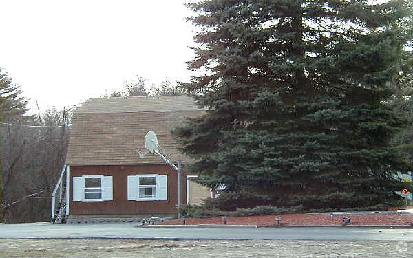
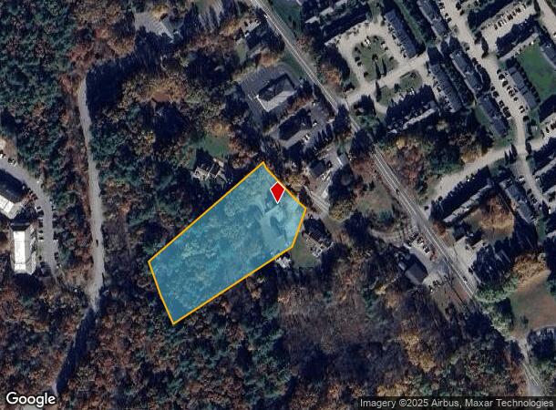
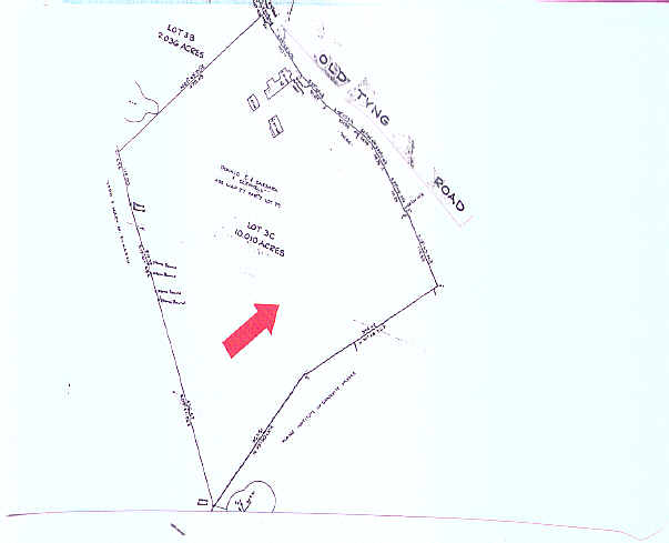
Property Record
10 Old Tyng Rd, Tyngsboro, MA 01879
NEARBY LISTINGS FOR SALE OR LEASE
Property Detail
10 Old Tyng Rd
TYNG-000027-000007
Middlesex
Commercialofficeresidentialmixeduse
Massachusetts
X
2.76 AC
25017C0116F
Groton/Townsend
2025
Boston
2025
Boston-Cambridge-Newton, MA-NH
313101
DEMOGRAPHICS near 10 Old Tyng Rd
1 Mile
3 Mile
5 Mile
2024 Total Population
3,179
30,559
138,587
2029 Population
3,155
30,311
137,143
Pop Growth 2024-2029
(0.75%)
(0.81%)
(1.04%)
Average Age
42
42
40
2024 Total Households
1,285
11,550
50,436
HH Growth 2024-2029
(0.93%)
(1.01%)
(1.01%)
Median Household Inc
$93,041
$103,526
$92,790
Avg Household Size
2.50
2.60
2.60
2024 Avg HH Vehicles
2.00
2.00
2.00
Median Home Value
$435,248
$445,156
$442,217
Median Year Built
1989
1983
1973
Nearby Places
Map Layers
Map Styles
 Street
 Aerial
- Restaurants
- Banks
- Shops
- Fitness
- Groceries
PUBLIC TRANSPORTATION
COMMUTER RAIL
Lowell (Lowell Line - Massachusetts Bay Transportation Authority Commuter Rail (Purple Line))
DRIVE
WALK
Distance
Lowell (Lowell Line - Massachusetts Bay Transportation Authority Commuter Rail (Purple Line))
12 min
6.1 mi
AIRPORT
Manchester Boston Regional
DRIVE
WALK
Distance
Manchester Boston Regional
36 min
23.6 mi
General Edward Lawrence Logan International
DRIVE
WALK
Distance
General Edward Lawrence Logan International
55 min
39.9 mi
Freight Ports
Port of Boston
DRIVE
WALK
Distance
Port of Boston
55 min
39.7 mi
Nearby Properties
Address
Land Use
TOTAL SIZE
Lot Size
Zoning
Address
Land Use
TOTAL SIZE
Lot Size
Zoning
23,251 SF
18.20 AC
SMF
Address
Land Use
TOTAL SIZE
Lot Size
Zoning
68.15 AC
R1
Address
Land Use
TOTAL SIZE
Lot Size
Zoning
44.39 AC
SMU
Address
Land Use
TOTAL SIZE
Lot Size
Zoning
199.97 AC
B2
Address
Land Use
TOTAL SIZE
Lot Size
Zoning
45.10 AC
R1
Address
Land Use
TOTAL SIZE
Lot Size
Zoning
8.30 AC
B3
Address
Land Use
TOTAL SIZE
Lot Size
Zoning
135,324 SF
70.07 AC
R1
Address
Land Use
TOTAL SIZE
Lot Size
Zoning
90,463 SF
8.56 AC
RA
Address
Land Use
TOTAL SIZE
Lot Size
Zoning
177.27 AC
R1
Address
Land Use
TOTAL SIZE
Lot Size
Zoning
12.26 AC
P
Address
Land Use
TOTAL SIZE
Lot Size
Zoning
91,202 SF
12.65 AC
SMU
Address
Land Use
TOTAL SIZE
Lot Size
Zoning
42,419 SF
2.80 AC
SSF
Address
Land Use
TOTAL SIZE
Lot Size
Zoning
50,000 SF
33.40 AC
IA
Address
Land Use
TOTAL SIZE
Lot Size
Zoning
8.20 AC
SSF
Address
Land Use
TOTAL SIZE
Lot Size
Zoning
71,911 SF
31.55 AC
SSF
Address
Land Use
TOTAL SIZE
Lot Size
Zoning
15.86 AC
B3
Address
Land Use
TOTAL SIZE
Lot Size
Zoning
3.77 AC
B3
Address
Land Use
TOTAL SIZE
Lot Size
Zoning
8.30 AC
R1
Address
Land Use
TOTAL SIZE
Lot Size
Zoning
576 SF
19.97 AC
SMU
Address
Land Use
TOTAL SIZE
Lot Size
Zoning
9.92 AC
SSF
Address
Land Use
TOTAL SIZE
Lot Size
Zoning
17.86 AC
I1
Address
Land Use
TOTAL SIZE
Lot Size
Zoning
39,464 SF
8.74 AC
B3
Address
Land Use
TOTAL SIZE
Lot Size
Zoning
42,354 SF
19.95 AC
I1
Address
Land Use
TOTAL SIZE
Lot Size
Zoning
83,000 SF
2.78 AC
R1
Address
Land Use
TOTAL SIZE
Lot Size
Zoning
4.62 AC
RC
Address
Land Use
TOTAL SIZE
Lot Size
Zoning
1.91 AC
RC
Address
Land Use
TOTAL SIZE
Lot Size
Zoning
2.59 AC
I1
Address
Land Use
TOTAL SIZE
Lot Size
Zoning
5.03 AC
B2
Address
Land Use
TOTAL SIZE
Lot Size
Zoning
6.88 AC
B1
Address
Land Use
TOTAL SIZE
Lot Size
Zoning
92,440 SF
B3
The World's #1 Commercial Real Estate Marketplace
Connect with us
© 2025 CoStar Group
The information above has been obtained from sources believed reliable. While we do not doubt its accuracy we have not verified it and make no guarantee, warranty or representation about it. It is your responsibility to independently confirm its accuracy and completeness. Any projections, opinions, assumptions, or estimates used are for example only and do not represent the current or future performance of the property. The value of this transaction to you depends on tax and other factors which should be evaluated by your tax, financial, and legal advisors. You and your advisors should conduct a careful, independent investigation of the property to determine to your satisfaction the suitability of the property for your needs.