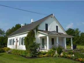
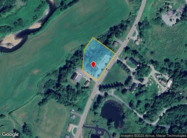
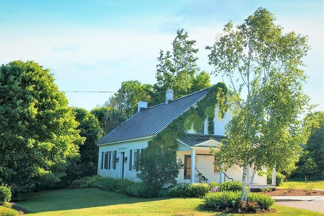
Property Record
10 Palmer Rd, Stowe, VT 05672
NEARBY LISTINGS FOR SALE OR LEASE
Property Detail
10 Palmer Rd
Commercialnec
1.51 AC & COMM BLDG
AE
Lamoille
5000660079E
Vermont
2024
1.51 AC
2024
Vermont North Area
953600
Other Market Areas
4,554 SF
621-195-11233
DEMOGRAPHICS near 10 Palmer Rd
1 Mile
3 Mile
5 Mile
2024 Total Population
1,075
4,724
7,380
2029 Population
1,113
4,933
7,695
Pop Growth 2024-2029
+ 3.53%
+ 4.42%
+ 4.27%
Average Age
43
43
43
2024 Total Households
452
2,035
3,196
HH Growth 2024-2029
+ 3.54%
+ 4.52%
+ 4.32%
Median Household Inc
$70,138
$76,934
$87,135
Avg Household Size
2.30
2.30
2.30
2024 Avg HH Vehicles
1.00
2.00
2.00
Median Home Value
$611,607
$610,098
$563,735
Median Year Built
1989
1989
1989
Nearby Places
- Restaurants
- Banks
- Shops
- Fitness
- Groceries
PUBLIC TRANSPORTATION
COMMUTER RAIL
Waterbury-Stowe Amtrak Station (Vermonter - Amtrak)
DRIVE
WALK
Distance
Waterbury-Stowe Amtrak Station (Vermonter - Amtrak)
15 min
9.5 mi
AIRPORT
Patrick Leahy Burlington International
DRIVE
WALK
Distance
Patrick Leahy Burlington International
52 min
33.6 mi
Freight Ports
Montreal
DRIVE
WALK
Distance
Montreal
161 min
114.6 mi
SALE & LEASE HISTORY
LISTING DATE
SALE/LEASE

Jun 28, 2021
For Sale
Nearby Properties
Address
Land Use
TOTAL SIZE
Lot Size
Zoning
Address
Land Use
TOTAL SIZE
Lot Size
Zoning
75,711 SF
2,570.58 AC
Address
Land Use
TOTAL SIZE
Lot Size
Zoning
75,711 SF
2,570.58 AC
Address
Land Use
TOTAL SIZE
Lot Size
Zoning
13.25 AC
Address
Land Use
TOTAL SIZE
Lot Size
Zoning
5.08 AC
Address
Land Use
TOTAL SIZE
Lot Size
Zoning
49.63 AC
Address
Land Use
TOTAL SIZE
Lot Size
Zoning
29.16 AC
Address
Land Use
TOTAL SIZE
Lot Size
Zoning
31.89 AC
Address
Land Use
TOTAL SIZE
Lot Size
Zoning
Address
Land Use
TOTAL SIZE
Lot Size
Zoning
71.62 AC
Address
Land Use
TOTAL SIZE
Lot Size
Zoning
1.45 AC
Address
Land Use
TOTAL SIZE
Lot Size
Zoning
189.16 AC
Address
Land Use
TOTAL SIZE
Lot Size
Zoning
15,529 SF
4.19 AC
Address
Land Use
TOTAL SIZE
Lot Size
Zoning
6,114 SF
175.50 AC
Address
Land Use
TOTAL SIZE
Lot Size
Zoning
35,244 SF
40.85 AC
Address
Land Use
TOTAL SIZE
Lot Size
Zoning
50.13 AC
Address
Land Use
TOTAL SIZE
Lot Size
Zoning
90.42 AC
Address
Land Use
TOTAL SIZE
Lot Size
Zoning
11,456 SF
3.71 AC
Address
Land Use
TOTAL SIZE
Lot Size
Zoning
2,690 SF
152.01 AC
Address
Land Use
TOTAL SIZE
Lot Size
Zoning
14.08 AC
Address
Land Use
TOTAL SIZE
Lot Size
Zoning
5,304 SF
9 AC
Address
Land Use
TOTAL SIZE
Lot Size
Zoning
8,389 SF
0.60 AC
Address
Land Use
TOTAL SIZE
Lot Size
Zoning
56.11 AC
Address
Land Use
TOTAL SIZE
Lot Size
Zoning
14.43 AC
Address
Land Use
TOTAL SIZE
Lot Size
Zoning
31.70 AC
Address
Land Use
TOTAL SIZE
Lot Size
Zoning
Address
Land Use
TOTAL SIZE
Lot Size
Zoning
25,990 SF
9.50 AC
Address
Land Use
TOTAL SIZE
Lot Size
Zoning
3,944 SF
107 AC
Address
Land Use
TOTAL SIZE
Lot Size
Zoning
33,848 SF
13.10 AC
Address
Land Use
TOTAL SIZE
Lot Size
Zoning
22,067 SF
9 AC
Address
Land Use
TOTAL SIZE
Lot Size
Zoning
152.63 AC
The World's #1 Commercial Real Estate Marketplace
Connect with us
© 2025 CoStar Group
The information above has been obtained from sources believed reliable. While we do not doubt its accuracy we have not verified it and make no guarantee, warranty or representation about it. It is your responsibility to independently confirm its accuracy and completeness. Any projections, opinions, assumptions, or estimates used are for example only and do not represent the current or future performance of the property. The value of this transaction to you depends on tax and other factors which should be evaluated by your tax, financial, and legal advisors. You and your advisors should conduct a careful, independent investigation of the property to determine to your satisfaction the suitability of the property for your needs.