Property Record
10 Pantigo Rd, East Hampton, NY 11937
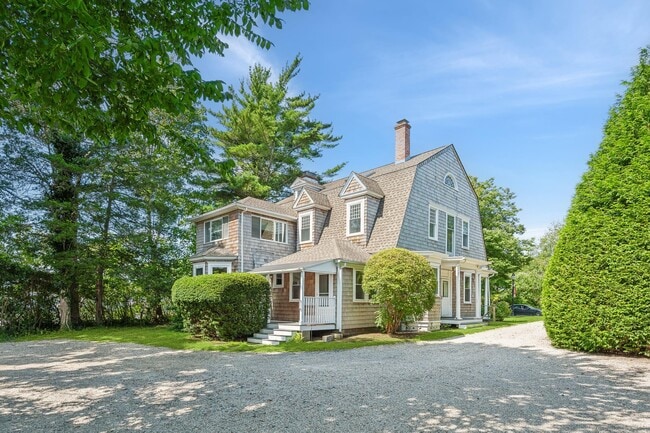
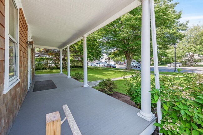
This Property Is For Sale
NEARBY LISTINGS FOR SALE OR LEASE
Property Detail
10 Pantigo Rd
Long Island (New York)
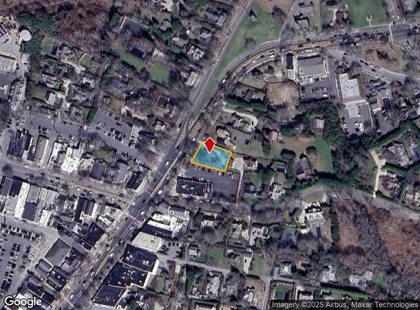
Map Whalebone Woods
Nassau County-Suffolk County, NY
Suffolk
0301-003-00-03-00-001-001
New York
Sfr
0.27 AC
X
Eastern Suffolk
36103C0558H
DEMOGRAPHICS near 10 Pantigo Rd
1 Mile
3 Mile
5 Mile
2024 Total Population
4,792
16,885
29,381
2029 Population
5,195
18,468
31,834
Pop Growth 2024-2029
+ 8.41%
+ 9.38%
+ 8.35%
Average Age
44
44
44
2024 Total Households
1,866
6,491
11,252
HH Growth 2024-2029
+ 9.22%
+ 9.69%
+ 8.51%
Median Household Inc
$112,500
$125,962
$130,568
Avg Household Size
2.60
2.60
2.60
2024 Avg HH Vehicles
2.00
2.00
2.00
Median Home Value
$1,099,812
$1,046,593
$1,004,473
Median Year Built
1967
1979
1980
Nearby Places
Map Layers
Map Styles
 Street
 Aerial
- Restaurants
- Banks
- Shops
- Fitness
- Groceries
PUBLIC TRANSPORTATION
COMMUTER RAIL
East Hampton Station (Montauk Branch - Long Island Rail Road)
DRIVE
WALK
Distance
East Hampton Station (Montauk Branch - Long Island Rail Road)
3 min
12 min
0.6 mi
Amagansett Station (Montauk Branch - Long Island Rail Road)
DRIVE
WALK
Distance
Amagansett Station (Montauk Branch - Long Island Rail Road)
6 min
3.0 mi
Freight Ports
Port of New Haven
DRIVE
WALK
Distance
Port of New Haven
200 min
89.4 mi
Nearby Properties
Address
Land Use
TOTAL SIZE
Lot Size
Zoning
Address
Land Use
TOTAL SIZE
Lot Size
Zoning
2,240 SF
19.46 AC
R40
Address
Land Use
TOTAL SIZE
Lot Size
Zoning
4,132 SF
1.08 AC
R40
Address
Land Use
TOTAL SIZE
Lot Size
Zoning
3,298 SF
0.18 AC
VILLA
Address
Land Use
TOTAL SIZE
Lot Size
Zoning
4,718 SF
1.09 AC
R20
Address
Land Use
TOTAL SIZE
Lot Size
Zoning
53.67 AC
Address
Land Use
TOTAL SIZE
Lot Size
Zoning
3.01 AC
Address
Land Use
TOTAL SIZE
Lot Size
Zoning
17.58 AC
Address
Land Use
TOTAL SIZE
Lot Size
Zoning
1.08 AC
VILLA
Address
Land Use
TOTAL SIZE
Lot Size
Zoning
2,196 SF
0.26 AC
B2
Address
Land Use
TOTAL SIZE
Lot Size
Zoning
2,039 SF
0.29 AC
HO
Address
Land Use
TOTAL SIZE
Lot Size
Zoning
Address
Land Use
TOTAL SIZE
Lot Size
Zoning
0.42 AC
B2
Address
Land Use
TOTAL SIZE
Lot Size
Zoning
0.77 AC
R80
Address
Land Use
TOTAL SIZE
Lot Size
Zoning
Address
Land Use
TOTAL SIZE
Lot Size
Zoning
0.50 AC
R20
Address
Land Use
TOTAL SIZE
Lot Size
Zoning
Address
Land Use
TOTAL SIZE
Lot Size
Zoning
8.10 AC
Address
Land Use
TOTAL SIZE
Lot Size
Zoning
2.10 AC
Address
Land Use
TOTAL SIZE
Lot Size
Zoning
0.82 AC
BD
Address
Land Use
TOTAL SIZE
Lot Size
Zoning
Address
Land Use
TOTAL SIZE
Lot Size
Zoning
0.03 AC
B2
Address
Land Use
TOTAL SIZE
Lot Size
Zoning
Address
Land Use
TOTAL SIZE
Lot Size
Zoning
4.38 AC
Address
Land Use
TOTAL SIZE
Lot Size
Zoning
79.86 AC
Address
Land Use
TOTAL SIZE
Lot Size
Zoning
0.08 AC
B2
Address
Land Use
TOTAL SIZE
Lot Size
Zoning
1.50 AC
Address
Land Use
TOTAL SIZE
Lot Size
Zoning
1.38 AC
Address
Land Use
TOTAL SIZE
Lot Size
Zoning
4.69 AC
Address
Land Use
TOTAL SIZE
Lot Size
Zoning
9.50 AC
Address
Land Use
TOTAL SIZE
Lot Size
Zoning
The World's #1 Commercial Real Estate Marketplace
Connect with us
© 2025 CoStar Group
The information above has been obtained from sources believed reliable. While we do not doubt its accuracy we have not verified it and make no guarantee, warranty or representation about it. It is your responsibility to independently confirm its accuracy and completeness. Any projections, opinions, assumptions, or estimates used are for example only and do not represent the current or future performance of the property. The value of this transaction to you depends on tax and other factors which should be evaluated by your tax, financial, and legal advisors. You and your advisors should conduct a careful, independent investigation of the property to determine to your satisfaction the suitability of the property for your needs.