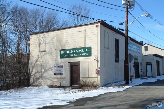
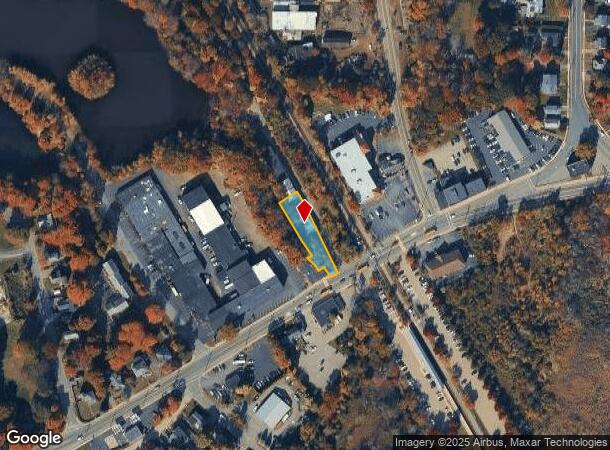
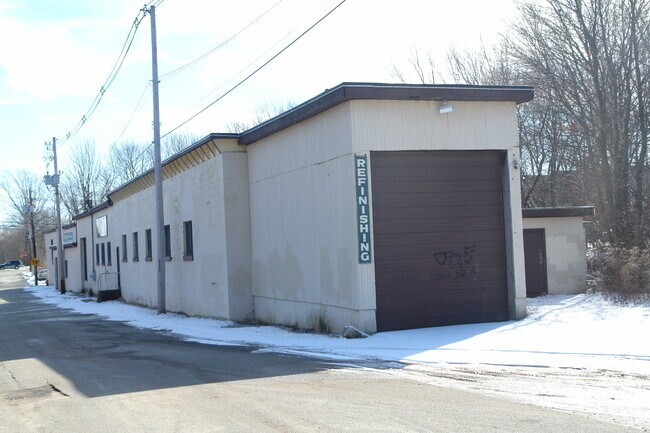
Property Record
10 Pond St, Whitman, MA 02382
NEARBY LISTINGS FOR SALE OR LEASE
Property Detail
10 Pond St
WHIT-000007-000057-000028
Plymouth
Manufacturinglight
Massachusetts
AE
28
25023C0183J
0.31 AC
2025
Route 3 South
2025
Boston
521201
Boston-Cambridge-Newton, MA-NH
10,161 SF
DEMOGRAPHICS near 10 Pond St
1 Mile
3 Mile
5 Mile
2024 Total Population
8,047
39,420
123,077
2029 Population
7,964
39,351
122,767
Pop Growth 2024-2029
(1.03%)
(0.18%)
(0.25%)
Average Age
40
41
41
2024 Total Households
3,042
14,557
43,732
HH Growth 2024-2029
(1.15%)
(0.31%)
(0.31%)
Median Household Inc
$94,485
$107,537
$97,008
Avg Household Size
2.60
2.60
2.70
2024 Avg HH Vehicles
2.00
2.00
2.00
Median Home Value
$420,268
$446,997
$429,978
Median Year Built
1948
1965
1964
Nearby Places
Map Layers
Map Styles
 Street
 Aerial
- Restaurants
- Banks
- Shops
- Fitness
- Groceries
PUBLIC TRANSPORTATION
TRANSIT/SUBWAY
Whitman (Kingston/Plymouth Line - Massachusetts Bay Transportation Authority Commuter Rail (Purple Line))
DRIVE
WALK
Distance
Whitman (Kingston/Plymouth Line - Massachusetts Bay Transportation Authority Commuter Rail (Purple Line))
1 min
2 min
0.1 mi
COMMUTER RAIL
Whitman (Kingston/Plymouth Line - Massachusetts Bay Transportation Authority Commuter Rail (Purple Line))
DRIVE
WALK
Distance
Whitman (Kingston/Plymouth Line - Massachusetts Bay Transportation Authority Commuter Rail (Purple Line))
1 min
2 min
0.1 mi
Abington (Kingston/Plymouth Line - Massachusetts Bay Transportation Authority Commuter Rail (Purple Line))
DRIVE
WALK
Distance
Abington (Kingston/Plymouth Line - Massachusetts Bay Transportation Authority Commuter Rail (Purple Line))
5 min
2.3 mi
AIRPORT
General Edward Lawrence Logan International
DRIVE
WALK
Distance
General Edward Lawrence Logan International
41 min
25.7 mi
Rhode Island Tf Green International
DRIVE
WALK
Distance
Rhode Island Tf Green International
76 min
43.9 mi
Nearby Properties
Address
Land Use
TOTAL SIZE
Lot Size
Zoning
Address
Land Use
TOTAL SIZE
Lot Size
Zoning
69.93 AC
100
Address
Land Use
TOTAL SIZE
Lot Size
Zoning
412,500 SF
48.94 AC
100
Address
Land Use
TOTAL SIZE
Lot Size
Zoning
36.20 AC
Address
Land Use
TOTAL SIZE
Lot Size
Zoning
35.10 AC
Address
Land Use
TOTAL SIZE
Lot Size
Zoning
99,138 SF
83.32 AC
100
Address
Land Use
TOTAL SIZE
Lot Size
Zoning
3.72 AC
INDUST
Address
Land Use
TOTAL SIZE
Lot Size
Zoning
16.12 AC
RESIDE
Address
Land Use
TOTAL SIZE
Lot Size
Zoning
2.24 AC
GB
Address
Land Use
TOTAL SIZE
Lot Size
Zoning
9.30 AC
BUSINE
Address
Land Use
TOTAL SIZE
Lot Size
Zoning
55.90 AC
Address
Land Use
TOTAL SIZE
Lot Size
Zoning
106,907 SF
26.42 AC
A1
Address
Land Use
TOTAL SIZE
Lot Size
Zoning
63,760 SF
9.67 AC
Address
Land Use
TOTAL SIZE
Lot Size
Zoning
43.94 AC
100
Address
Land Use
TOTAL SIZE
Lot Size
Zoning
127,644 SF
15.76 AC
Address
Land Use
TOTAL SIZE
Lot Size
Zoning
78,120 SF
1.61 AC
GB
Address
Land Use
TOTAL SIZE
Lot Size
Zoning
116,122 SF
19.57 AC
Address
Land Use
TOTAL SIZE
Lot Size
Zoning
118,745 SF
18.78 AC
Address
Land Use
TOTAL SIZE
Lot Size
Zoning
60,840 SF
1.17 AC
Address
Land Use
TOTAL SIZE
Lot Size
Zoning
25.10 AC
Address
Land Use
TOTAL SIZE
Lot Size
Zoning
66,412 SF
10.36 AC
HB
Address
Land Use
TOTAL SIZE
Lot Size
Zoning
16.12 AC
100
Address
Land Use
TOTAL SIZE
Lot Size
Zoning
13.56 AC
Address
Land Use
TOTAL SIZE
Lot Size
Zoning
87,103 SF
8.60 AC
A1
Address
Land Use
TOTAL SIZE
Lot Size
Zoning
40,466 SF
19 AC
RESIDE
Address
Land Use
TOTAL SIZE
Lot Size
Zoning
92,516 SF
12.68 AC
GR
Address
Land Use
TOTAL SIZE
Lot Size
Zoning
53,503 SF
2.21 AC
HB
Address
Land Use
TOTAL SIZE
Lot Size
Zoning
3.20 AC
Address
Land Use
TOTAL SIZE
Lot Size
Zoning
85,465 SF
13.63 AC
INDUST
Address
Land Use
TOTAL SIZE
Lot Size
Zoning
38,351 SF
5.80 AC
RESIDE
Address
Land Use
TOTAL SIZE
Lot Size
Zoning
38,784 SF
7.70 AC
The World's #1 Commercial Real Estate Marketplace
Connect with us
© 2026 CoStar Group
The information above has been obtained from sources believed reliable. While we do not doubt its accuracy we have not verified it and make no guarantee, warranty or representation about it. It is your responsibility to independently confirm its accuracy and completeness. Any projections, opinions, assumptions, or estimates used are for example only and do not represent the current or future performance of the property. The value of this transaction to you depends on tax and other factors which should be evaluated by your tax, financial, and legal advisors. You and your advisors should conduct a careful, independent investigation of the property to determine to your satisfaction the suitability of the property for your needs.