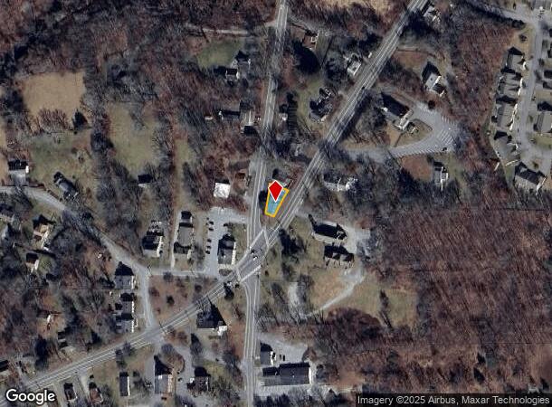
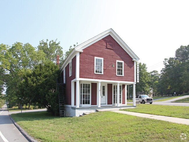
Property Record
10 Providence Rd, Brooklyn, CT 06234

NEARBY LISTINGS FOR SALE OR LEASE
Property Detail
10 Providence Rd
BROO-000024-000000-000057
Windham
Commercialbuilding
Connecticut
X
57
09015C0237F
0.10 AC
2025
Windham County
2025
Hartford
905102
Willimantic, CT
1,986 SF
DEMOGRAPHICS near 10 Providence Rd
1 Mile
3 Mile
5 Mile
2024 Total Population
1,559
7,953
22,844
2029 Population
1,555
7,963
22,770
Pop Growth 2024-2029
(0.26%)
+ 0.13%
(0.32%)
Average Age
45
43
42
2024 Total Households
511
2,935
9,009
HH Growth 2024-2029
(0.98%)
+ 0.03%
(0.28%)
Median Household Inc
$87,162
$84,749
$75,530
Avg Household Size
2.30
2.50
2.40
2024 Avg HH Vehicles
2.00
2.00
2.00
Median Home Value
$261,788
$263,304
$242,876
Median Year Built
1977
1978
1969
Nearby Places
Map Layers
Map Styles
 Street
 Aerial
- Restaurants
- Banks
- Shops
- Fitness
- Groceries
PUBLIC TRANSPORTATION
AIRPORT
Rhode Island Tf Green International
DRIVE
WALK
Distance
Rhode Island Tf Green International
47 min
35.3 mi
Freight Ports
Port of Davisville, RI
DRIVE
WALK
Distance
Port of Davisville, RI
59 min
44.6 mi
Nearby Properties
Address
Land Use
TOTAL SIZE
Lot Size
Zoning
Address
Land Use
TOTAL SIZE
Lot Size
Zoning
54.70 AC
RA
Address
Land Use
TOTAL SIZE
Lot Size
Zoning
14.15 AC
VC
Address
Land Use
TOTAL SIZE
Lot Size
Zoning
147,139 SF
25.48 AC
PC
Address
Land Use
TOTAL SIZE
Lot Size
Zoning
5 AC
VC
Address
Land Use
TOTAL SIZE
Lot Size
Zoning
24.12 AC
VC
Address
Land Use
TOTAL SIZE
Lot Size
Zoning
9.77 AC
PC
Address
Land Use
TOTAL SIZE
Lot Size
Zoning
19.85 AC
R30
Address
Land Use
TOTAL SIZE
Lot Size
Zoning
13,472 SF
1.40 AC
PC
Address
Land Use
TOTAL SIZE
Lot Size
Zoning
31 AC
RA
Address
Land Use
TOTAL SIZE
Lot Size
Zoning
17,473 SF
3.49 AC
PC
Address
Land Use
TOTAL SIZE
Lot Size
Zoning
4.90 AC
RA
Address
Land Use
TOTAL SIZE
Lot Size
Zoning
3,536 SF
27.50 AC
RA
Address
Land Use
TOTAL SIZE
Lot Size
Zoning
25,942 SF
3.52 AC
R10
Address
Land Use
TOTAL SIZE
Lot Size
Zoning
5,222 SF
157.70 AC
R30
Address
Land Use
TOTAL SIZE
Lot Size
Zoning
21,582 SF
2.10 AC
GC
Address
Land Use
TOTAL SIZE
Lot Size
Zoning
2.90 AC
PC
Address
Land Use
TOTAL SIZE
Lot Size
Zoning
1.58 AC
VC
Address
Land Use
TOTAL SIZE
Lot Size
Zoning
5,100 SF
7.49 AC
PC
Address
Land Use
TOTAL SIZE
Lot Size
Zoning
5,152 SF
1.62 AC
PC
Address
Land Use
TOTAL SIZE
Lot Size
Zoning
21,424 SF
3.97 AC
LI
Address
Land Use
TOTAL SIZE
Lot Size
Zoning
2,561 SF
6.13 AC
PC
Address
Land Use
TOTAL SIZE
Lot Size
Zoning
4,056 SF
1.40 AC
PC
Address
Land Use
TOTAL SIZE
Lot Size
Zoning
12,880 SF
5.84 AC
PC
Address
Land Use
TOTAL SIZE
Lot Size
Zoning
5.66 AC
VC
Address
Land Use
TOTAL SIZE
Lot Size
Zoning
10 AC
RA
Address
Land Use
TOTAL SIZE
Lot Size
Zoning
0.97 AC
R10
Address
Land Use
TOTAL SIZE
Lot Size
Zoning
1.27 AC
PC
Address
Land Use
TOTAL SIZE
Lot Size
Zoning
6,791 SF
0.95 AC
PC
Address
Land Use
TOTAL SIZE
Lot Size
Zoning
14,768 SF
2.46 AC
VC
Address
Land Use
TOTAL SIZE
Lot Size
Zoning
3,132 SF
1.56 AC
PC
The World's #1 Commercial Real Estate Marketplace
Connect with us
© 2026 CoStar Group
The information above has been obtained from sources believed reliable. While we do not doubt its accuracy we have not verified it and make no guarantee, warranty or representation about it. It is your responsibility to independently confirm its accuracy and completeness. Any projections, opinions, assumptions, or estimates used are for example only and do not represent the current or future performance of the property. The value of this transaction to you depends on tax and other factors which should be evaluated by your tax, financial, and legal advisors. You and your advisors should conduct a careful, independent investigation of the property to determine to your satisfaction the suitability of the property for your needs.