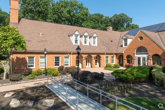
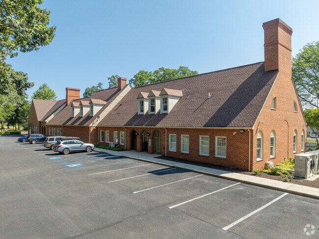
Property Record
10 Route 31 N, Pennington, NJ 08534

Current Lease Availabilities
NEARBY LISTINGS FOR SALE OR LEASE
Property Detail
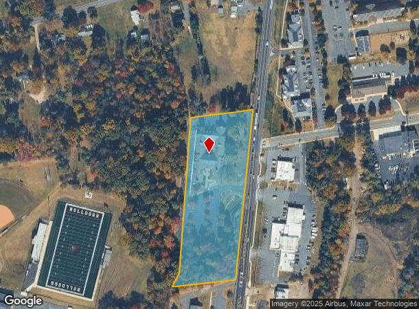
10 Route 31 N
08-00201-0000-00005
Mercer
Officebuilding
New Jersey
X
5
34021C0108F
4.83 AC
2024
Trenton
2025
Northern New Jersey
003903
Trenton, NJ
4,616 SF
DEMOGRAPHICS near 10 Route 31 N
1 Mile
3 Mile
5 Mile
2024 Total Population
3,734
13,040
52,343
2029 Population
3,699
12,840
51,760
Pop Growth 2024-2029
(0.94%)
(1.53%)
(1.11%)
Average Age
44
43
43
2024 Total Households
1,399
4,836
19,575
HH Growth 2024-2029
(0.71%)
(1.57%)
(1.20%)
Median Household Inc
$135,051
$136,430
$119,622
Avg Household Size
2.60
2.60
2.50
2024 Avg HH Vehicles
2.00
2.00
2.00
Median Home Value
$584,586
$505,998
$393,320
Median Year Built
1962
1981
1975
Nearby Places
Map Layers
Map Styles
 Street
 Aerial
- Restaurants
- Banks
- Shops
- Fitness
- Groceries
PUBLIC TRANSPORTATION
COMMUTER RAIL
West Trenton (R3 - Southeastern Pennsylvania Transportation Authority Regional Rail (SEPTA Regional Rail))
DRIVE
WALK
Distance
West Trenton (R3 - Southeastern Pennsylvania Transportation Authority Regional Rail (SEPTA Regional Rail))
14 min
7.5 mi
Princeton (Princeton Branch - NJ Transit Commuter Rail (NJ Transit))
DRIVE
WALK
Distance
Princeton (Princeton Branch - NJ Transit Commuter Rail (NJ Transit))
20 min
9.0 mi
AIRPORT
Trenton Mercer
DRIVE
WALK
Distance
Trenton Mercer
12 min
5.2 mi
Freight Ports
Port of Philadelphia
DRIVE
WALK
Distance
Port of Philadelphia
50 min
34.5 mi
Nearby Properties
Address
Land Use
TOTAL SIZE
Lot Size
Zoning
Address
Land Use
TOTAL SIZE
Lot Size
Zoning
42 AC
R03
Address
Land Use
TOTAL SIZE
Lot Size
Zoning
13.86 AC
OP
Address
Land Use
TOTAL SIZE
Lot Size
Zoning
156.92 AC
R03
Address
Land Use
TOTAL SIZE
Lot Size
Zoning
Address
Land Use
TOTAL SIZE
Lot Size
Zoning
13.36 AC
OP
Address
Land Use
TOTAL SIZE
Lot Size
Zoning
0.35 AC
OP
Address
Land Use
TOTAL SIZE
Lot Size
Zoning
7.85 AC
OP
Address
Land Use
TOTAL SIZE
Lot Size
Zoning
6.09 AC
OP
Address
Land Use
TOTAL SIZE
Lot Size
Zoning
8.73 AC
OP
Address
Land Use
TOTAL SIZE
Lot Size
Zoning
Address
Land Use
TOTAL SIZE
Lot Size
Zoning
38.82 AC
R100
Address
Land Use
TOTAL SIZE
Lot Size
Zoning
0.32 AC
OP
Address
Land Use
TOTAL SIZE
Lot Size
Zoning
6.37 AC
OP
Address
Land Use
TOTAL SIZE
Lot Size
Zoning
6.01 AC
OP
Address
Land Use
TOTAL SIZE
Lot Size
Zoning
8.35 AC
OP
Address
Land Use
TOTAL SIZE
Lot Size
Zoning
20.93 AC
HBO
Address
Land Use
TOTAL SIZE
Lot Size
Zoning
58,800 SF
20.55 AC
IP1
Address
Land Use
TOTAL SIZE
Lot Size
Zoning
0.27 AC
OP
Address
Land Use
TOTAL SIZE
Lot Size
Zoning
9.87 AC
R-5
Address
Land Use
TOTAL SIZE
Lot Size
Zoning
221.99 AC
2ZON
Address
Land Use
TOTAL SIZE
Lot Size
Zoning
13.26 AC
IP-1
Address
Land Use
TOTAL SIZE
Lot Size
Zoning
17,000 SF
32.87 AC
R-80
Address
Land Use
TOTAL SIZE
Lot Size
Zoning
Address
Land Use
TOTAL SIZE
Lot Size
Zoning
16.34 AC
SC
Address
Land Use
TOTAL SIZE
Lot Size
Zoning
22.61 AC
IP-1
Address
Land Use
TOTAL SIZE
Lot Size
Zoning
0.34 AC
OP
Address
Land Use
TOTAL SIZE
Lot Size
Zoning
Address
Land Use
TOTAL SIZE
Lot Size
Zoning
22.37 AC
2ZON
Address
Land Use
TOTAL SIZE
Lot Size
Zoning
0.25 AC
OP
Address
Land Use
TOTAL SIZE
Lot Size
Zoning
The World's #1 Commercial Real Estate Marketplace
Connect with us
© 2026 CoStar Group
The information above has been obtained from sources believed reliable. While we do not doubt its accuracy we have not verified it and make no guarantee, warranty or representation about it. It is your responsibility to independently confirm its accuracy and completeness. Any projections, opinions, assumptions, or estimates used are for example only and do not represent the current or future performance of the property. The value of this transaction to you depends on tax and other factors which should be evaluated by your tax, financial, and legal advisors. You and your advisors should conduct a careful, independent investigation of the property to determine to your satisfaction the suitability of the property for your needs.