Property Record
10 S 56Th Pl, Ridgefield, WA 98642

NEARBY LISTINGS FOR SALE OR LEASE
-
-
View all Ridgefield listings for sale on LoopNet.com
Property Detail
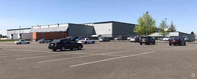
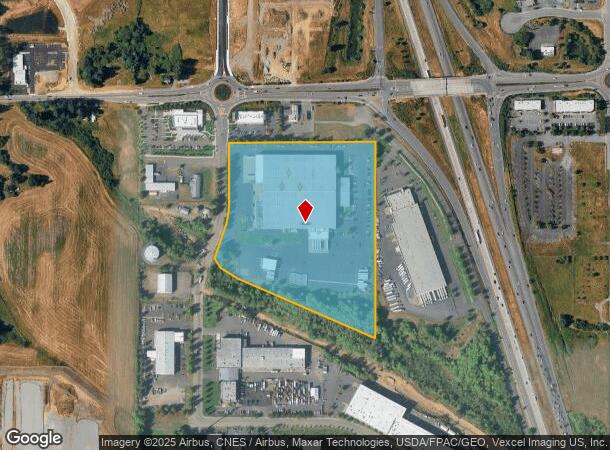
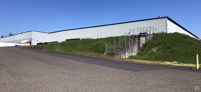
10 S 56Th Pl
214055-000
#96 SEC 21 T4N R1EWM 16.83A M/L FOR ASSESSOR USE ONLY PTN W1/2 OF SE1/4 SEC 21 DAF: BEG AT A WSH DEPT CONCRETE MNMNT AT NE COR OF SE1/4 SEC 21 TH S 89DG 3604 W ALG NLY LI SD SE1/4 1301.45 FT TO NE COR W1/2 OF SD SE1/4 TH S 00DG 2228 W ALG ELY LI SD W
Foodprocessing
Clark
X
Washington
53015C1005G
16.83 AC
2025
Clark County Outlying
2025
Portland
040303
Portland-Vancouver-Hillsboro, OR-WA
170,500 SF
DEMOGRAPHICS near 10 S 56Th Pl
1 Mile
3 Mile
5 Mile
2024 Total Population
5,223
19,313
32,384
2029 Population
5,936
21,605
35,756
Pop Growth 2024-2029
+ 13.65%
+ 11.87%
+ 10.41%
Average Age
38
39
41
2024 Total Households
1,769
6,496
11,104
HH Growth 2024-2029
+ 13.79%
+ 11.99%
+ 10.49%
Median Household Inc
$104,971
$101,250
$103,220
Avg Household Size
2.90
3.00
2.90
2024 Avg HH Vehicles
2.00
2.00
2.00
Median Home Value
$576,605
$599,593
$621,895
Median Year Built
2010
2010
2003
Nearby Places
Map Layers
Map Styles
 Street
 Aerial
- Restaurants
- Banks
- Shops
- Fitness
- Groceries
PUBLIC TRANSPORTATION
AIRPORT
Portland International
DRIVE
WALK
Distance
Portland International
33 min
22.9 mi
Freight Ports
Port of Vancouver
DRIVE
WALK
Distance
Port of Vancouver
26 min
16.0 mi
Nearby Properties
Address
Land Use
TOTAL SIZE
Lot Size
Zoning
Address
Land Use
TOTAL SIZE
Lot Size
Zoning
741,237 SF
42.05 AC
E
Address
Land Use
TOTAL SIZE
Lot Size
Zoning
299,106 SF
16.63 AC
RMD-16
Address
Land Use
TOTAL SIZE
Lot Size
Zoning
665,040 SF
57.82 AC
E
Address
Land Use
TOTAL SIZE
Lot Size
Zoning
468,420 SF
38.81 AC
E
Address
Land Use
TOTAL SIZE
Lot Size
Zoning
145,300 SF
31.34 AC
PF
Address
Land Use
TOTAL SIZE
Lot Size
Zoning
99,600 SF
4.38 AC
CCB
Address
Land Use
TOTAL SIZE
Lot Size
Zoning
343,528 SF
32.10 AC
PF
Address
Land Use
TOTAL SIZE
Lot Size
Zoning
113,250 SF
20.40 AC
E
Address
Land Use
TOTAL SIZE
Lot Size
Zoning
153,436 SF
17.03 AC
CRB
Address
Land Use
TOTAL SIZE
Lot Size
Zoning
104,246 SF
8.56 AC
PF
Address
Land Use
TOTAL SIZE
Lot Size
Zoning
76,536 SF
2.64 AC
RMD-16
Address
Land Use
TOTAL SIZE
Lot Size
Zoning
1,301 SF
69.17 AC
AG-20
Address
Land Use
TOTAL SIZE
Lot Size
Zoning
117,494 SF
9.08 AC
E
Address
Land Use
TOTAL SIZE
Lot Size
Zoning
181,560 SF
9 AC
E
Address
Land Use
TOTAL SIZE
Lot Size
Zoning
112,220 SF
6.44 AC
E
Address
Land Use
TOTAL SIZE
Lot Size
Zoning
108,939 SF
6.32 AC
E
Address
Land Use
TOTAL SIZE
Lot Size
Zoning
49,840 SF
9.76 AC
CRB
Address
Land Use
TOTAL SIZE
Lot Size
Zoning
141,500 SF
11.71 AC
E
Address
Land Use
TOTAL SIZE
Lot Size
Zoning
74,640 SF
11.40 AC
E
Address
Land Use
TOTAL SIZE
Lot Size
Zoning
77,620 SF
7.95 AC
E
Address
Land Use
TOTAL SIZE
Lot Size
Zoning
83,660 SF
5.72 AC
E
Address
Land Use
TOTAL SIZE
Lot Size
Zoning
129,977 SF
6.02 AC
E
Address
Land Use
TOTAL SIZE
Lot Size
Zoning
52,000 SF
5.67 AC
E
Address
Land Use
TOTAL SIZE
Lot Size
Zoning
37,500 SF
10.90 AC
E
Address
Land Use
TOTAL SIZE
Lot Size
Zoning
55,184 SF
8.37 AC
PF
Address
Land Use
TOTAL SIZE
Lot Size
Zoning
1,600 SF
31.43 AC
JP
Address
Land Use
TOTAL SIZE
Lot Size
Zoning
52,853 SF
4.55 AC
CCB
Address
Land Use
TOTAL SIZE
Lot Size
Zoning
52,937 SF
3.93 AC
E
Address
Land Use
TOTAL SIZE
Lot Size
Zoning
50,260 SF
3.38 AC
E
The World's #1 Commercial Real Estate Marketplace
Connect with us
© 2026 CoStar Group
The information above has been obtained from sources believed reliable. While we do not doubt its accuracy we have not verified it and make no guarantee, warranty or representation about it. It is your responsibility to independently confirm its accuracy and completeness. Any projections, opinions, assumptions, or estimates used are for example only and do not represent the current or future performance of the property. The value of this transaction to you depends on tax and other factors which should be evaluated by your tax, financial, and legal advisors. You and your advisors should conduct a careful, independent investigation of the property to determine to your satisfaction the suitability of the property for your needs.